
KML is from Wikidata
Chelmsford | |
|---|---|
 CM | |
| Coordinates: 51°45′14″N 0°23′56″E / 51.754°N 0.399°E | |
| Country | United Kingdom |
| Postcode area | CM |
| Postcode area name | Chelmsford |
| Post towns | 16 |
| Postcode districts | 28 |
| Postcode sectors | 103 |
| Postcodes (live) | 17,864 |
| Postcodes (total) | 27,233 |
| Statistics as at May 2020[1] | |
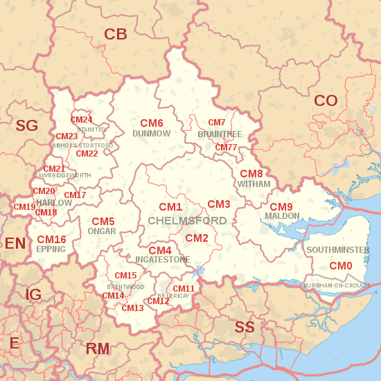
The CM postcode area, also known as the Chelmsford postcode area,[2] is a group of 25 postcode districts in England, within 16 post towns. These cover central Essex (including Chelmsford, Harlow, Brentwood, Billericay, Braintree, Burnham-on-Crouch, Dunmow, Epping, Ingatestone, Maldon, Ongar, Southminster, Stansted and Witham), plus a small part of east Hertfordshire (including Bishop's Stortford and Sawbridgeworth) and a very small part of the London Borough of Havering.
The southern part of the CM7 district for Braintree was recoded to CM77 in 2002.[3]
YouTube Encyclopedic
-
1/5Views:3 2445 3966 7593314 970
-
Grammar School Application Advice and Information
-
CSCS Test Questions and Answers
-
Area Conversion (Introduction to the conversion between area units)
-
Forklift Operators Course
-
CSCS Health and Safety test for Operatives
Transcription
Coverage
The Stansted post town (CM24) is entirely surrounded by the Bishop's Stortford post town (CM22 and CM23).[2] The approximate coverage of the postcode districts:
| Postcode district | Post town | Coverage | Local authority area(s) |
|---|---|---|---|
| CM0 | SOUTHMINSTER | Southminster, Bradwell, Tillingham, Asheldham, Dengie | Maldon |
| BURNHAM-ON-CROUCH | Burnham-on-Crouch, Tillingham | ||
| CM1 | CHELMSFORD | Chelmsford, Writtle | Chelmsford, Uttlesford |
| CM2 | CHELMSFORD | Chelmsford | Chelmsford |
| CM3 | CHELMSFORD | Hatfield Peverel, South Woodham Ferrers, North Fambridge, Cold Norton, Boreham, Maylandsea | Chelmsford, Maldon, Braintree, Uttlesford |
| CM4 | INGATESTONE | Blackmore, Fryerning, Ingatestone, Margaretting, Stock | Brentwood, Chelmsford, Epping Forest |
| CM5 | ONGAR | Chipping Ongar, High Ongar, Bobbingworth, Moreton, The Lavers, The Rodings | Epping Forest, Chelmsford |
| CM6 | DUNMOW | Great Dunmow, Felsted | Uttlesford, Chelmsford |
| CM7 | BRAINTREE | Braintree, Finchingfield, Great Bardfield | Braintree, Uttlesford |
| CM8 | WITHAM | Witham | Braintree, Maldon |
| CM9 | MALDON | Maldon, Tollesbury, Tolleshunt D'Arcy, Tolleshunt Knights | Maldon, Colchester, Chelmsford |
| CM11 | BILLERICAY | Billericay (East), Great Burstead | Basildon, Chelmsford |
| CM12 | BILLERICAY | Billericay (West), Little Burstead | Basildon, Brentwood |
| CM13 | BRENTWOOD | Brentwood, East Horndon, Great Warley, Herongate, Hutton, Ingrave, Little Warley, West Horndon | Brentwood, Basildon, Havering |
| CM14 | BRENTWOOD | Brentwood, Warley | Brentwood, Havering |
| CM15 | BRENTWOOD | Brentwood, Doddinghurst, Kelvedon Hatch, Mountnessing, Shenfield, Stondon Massey, Pilgrims Hatch | Brentwood |
| CM16 | EPPING | Epping, Theydon Bois, North Weald | Epping Forest |
| CM17 | HARLOW | Harlow, Old Harlow, Matching, Matching Tye, Matching Green, Church Langley | Harlow, Epping Forest, Uttlesford |
| CM18 | HARLOW | Harlow | Harlow, Epping Forest |
| CM19 | HARLOW | Harlow, Roydon | Harlow, Epping Forest |
| CM20 | HARLOW | Harlow, Gilston | Harlow, East Hertfordshire |
| CM21 | SAWBRIDGEWORTH | Sawbridgeworth | East Hertfordshire, Epping Forest |
| CM22 | BISHOP'S STORTFORD | Bishop's Stortford, Sheering | Uttlesford, East Hertfordshire, Epping Forest |
| CM23 | BISHOP'S STORTFORD | Bishop's Stortford, Thorley, Manuden | East Hertfordshire, Uttlesford |
| CM24 | STANSTED | Stansted Mountfitchet, Stansted Airport | Uttlesford |
| CM77 | BRAINTREE | Braintree, Great Notley, Rayne | Braintree, Uttlesford, Chelmsford |
| CM92 | CHELMSFORD | Sandringham House | non-geographic |
| CM98 | CHELMSFORD | Jobcentre Plus | non-geographic |
| CM99 | CHELMSFORD | PO Box Users | non-geographic |
Map
KML is from Wikidata
See also
References
- ^ "ONS Postcode Directory Version Notes" (ZIP). National Statistics Postcode Products. Office for National Statistics. May 2020. Table 2. Retrieved 19 June 2020. Coordinates from mean of unit postcode points, "Code-Point Open". OS OpenData. Ordnance Survey. February 2012. Retrieved 21 April 2012.
- ^ a b Royal Mail, Address Management Guide, (2004)
- ^ "Royal Mail Update 34". Beacon Dodsworth. Retrieved 23 August 2015.