
KML is from Wikidata
Hemel Hempstead | |
|---|---|
 HP | |
| Coordinates: 51°43′23″N 0°41′17″W / 51.723°N 0.688°W | |
| Country | United Kingdom |
| Postcode area | HP |
| Postcode area name | Hemel Hempstead |
| Post towns | 11 |
| Postcode districts | 24 |
| Postcode sectors | 77 |
| Postcodes (live) | 13,915 |
| Postcodes (total) | 21,705 |
| Statistics as at May 2020[1] | |
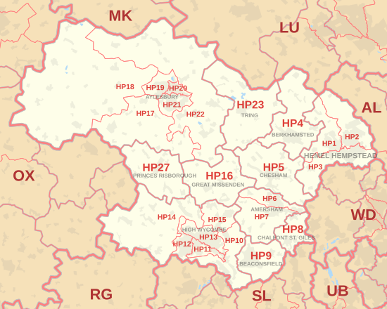
The HP postcode area, also known as the Hemel Hempstead postcode area,[2] is a group of twenty-four postcode districts in England, within eleven post towns. These cover north-west Hertfordshire (including Hemel Hempstead, Berkhamsted and Tring) and central Buckinghamshire (including Aylesbury, High Wycombe, Beaconsfield, Amersham, Chalfont St Giles, Chesham, Great Missenden and Princes Risborough).
Mail for this area is sorted at the Home Counties North Mail Centre in Hemel Hempstead.
YouTube Encyclopedic
-
1/5Views:332 7359174143 0668 244
-
Gk Trick | सभी राज्यों के पिन कोड | All India State Pin Code | Pin Code
-
The New Normal in Hospitality Industry (Webinar)
-
Latest Notification for Post Code 747 Regarding Staff Nurse commission
-
How to Go Back India from Malaysia भारत वापस कैसे जाएं, full detail by Dunia Di Sair
-
ITI भर्ती 2019 | Contract Based ITI NAUKRI 2019
Transcription
Coverage
The approximate coverage of the postcode districts:
Map
KML is from Wikidata
See also
References
- ^ "ONS Postcode Directory Version Notes" (ZIP). National Statistics Postcode Products. Office for National Statistics. May 2020. Table 2. Retrieved 19 June 2020. Coordinates from mean of unit postcode points, "Code-Point Open". OS OpenData. Ordnance Survey. February 2012. Retrieved 21 April 2012.
- ^ Royal Mail, Address Management Guide, (2004)
- ^ "Non Geographic Codes" (PDF). Royal Mail Address Management Unit. July 2012. Archived from the original (PDF) on 16 September 2012. Retrieved 20 December 2012.
- ^ "New sectors and localities to 14 December 2012" (PDF). Royal Mail Address Management Unit. 20 December 2012. Archived from the original (PDF) on 2 February 2015. Retrieved 20 December 2012.