
Zilair
Зилаир | |
|---|---|
 View of Zilair sign | |
 Flag | |
Location of Zilair  | |
 Zilair Location of Zilair 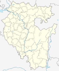 Zilair Zilair (Bashkortostan) | |
| Coordinates: 52°13′56″N 57°26′25″E / 52.23222°N 57.44028°E | |
| Country | Russia |
| Federal subject | Bashkortostan[1] |
| Administrative district | Zilairsky District[1] |
| Founded | 1748 |
| Elevation | 540 m (1,770 ft) |
| Population | |
| • Total | 5,585 |
| • Capital of | Zilairsky District[1] |
| Time zone | UTC+5 (MSK+2 |
| Postal code(s)[3] | 453680 |
| OKTMO ID | 80627416101 |
Zilair (Russian: Зилаи́р; Bashkir: Йылайыр, Yılayır) is a rural locality (a selo) and the administrative center of Zilairsky District in the Republic of Bashkortostan, Russia. Population: 5,585 (2010 Census);[1] 5,861 (2002 Census);[4] 5,037 (1989 Census).[5]
YouTube Encyclopedic
-
1/3Views:2 620373981
-
Zil Air Helicopter Tour of Mahe, Seychelles Islands
-
Zil Air Heli Landing @ Felicite Island Nov 2014
-
Zil Air - More than just a flight
Transcription
Climate
| Climate data for Zilair (extremes 1936-present) | |||||||||||||
|---|---|---|---|---|---|---|---|---|---|---|---|---|---|
| Month | Jan | Feb | Mar | Apr | May | Jun | Jul | Aug | Sep | Oct | Nov | Dec | Year |
| Record high °C (°F) | 12.0 (53.6) |
12.3 (54.1) |
15.4 (59.7) |
27.6 (81.7) |
33.3 (91.9) |
36.0 (96.8) |
38.4 (101.1) |
36.5 (97.7) |
35.3 (95.5) |
23.4 (74.1) |
14.3 (57.7) |
6.8 (44.2) |
38.4 (101.1) |
| Mean daily maximum °C (°F) | −8.8 (16.2) |
−6.8 (19.8) |
−0.4 (31.3) |
9.9 (49.8) |
19.0 (66.2) |
23.6 (74.5) |
25.0 (77.0) |
23.8 (74.8) |
17.0 (62.6) |
8.3 (46.9) |
−1.9 (28.6) |
−7.3 (18.9) |
8.5 (47.2) |
| Daily mean °C (°F) | −13.1 (8.4) |
−12.1 (10.2) |
−5.6 (21.9) |
4.2 (39.6) |
12.2 (54.0) |
16.8 (62.2) |
18.5 (65.3) |
16.8 (62.2) |
10.4 (50.7) |
3.3 (37.9) |
−5.4 (22.3) |
−11.4 (11.5) |
2.9 (37.2) |
| Mean daily minimum °C (°F) | −16.8 (1.8) |
−16.7 (1.9) |
−10.4 (13.3) |
−1.1 (30.0) |
5.4 (41.7) |
9.9 (49.8) |
12.2 (54.0) |
10.3 (50.5) |
4.6 (40.3) |
−0.9 (30.4) |
−8.4 (16.9) |
−15.1 (4.8) |
−2.3 (28.0) |
| Record low °C (°F) | −44.1 (−47.4) |
−46.9 (−52.4) |
−39.6 (−39.3) |
−32.2 (−26.0) |
−10.0 (14.0) |
−5.4 (22.3) |
−0.5 (31.1) |
−3.9 (25.0) |
−11.2 (11.8) |
−28.6 (−19.5) |
−39.6 (−39.3) |
−41.6 (−42.9) |
−46.9 (−52.4) |
| Average precipitation mm (inches) | 41.8 (1.65) |
38.4 (1.51) |
42.7 (1.68) |
42.1 (1.66) |
40.5 (1.59) |
45.1 (1.78) |
50.6 (1.99) |
36.3 (1.43) |
37.9 (1.49) |
49.6 (1.95) |
48.4 (1.91) |
46.4 (1.83) |
519.8 (20.47) |
| Source: pogoda.ru.net[6] | |||||||||||||
References
- ^ a b c d e f g Russian Federal State Statistics Service (2011). Всероссийская перепись населения 2010 года. Том 1 [2010 All-Russian Population Census, vol. 1]. Всероссийская перепись населения 2010 года [2010 All-Russia Population Census] (in Russian). Federal State Statistics Service.
- ^ "Об исчислении времени". Официальный интернет-портал правовой информации (in Russian). June 3, 2011. Retrieved January 19, 2019.
- ^ Почта России. Информационно-вычислительный центр ОАСУ РПО. (Russian Post). Поиск объектов почтовой связи (Postal Objects Search) (in Russian)
- ^ Russian Federal State Statistics Service (May 21, 2004). Численность населения России, субъектов Российской Федерации в составе федеральных округов, районов, городских поселений, сельских населённых пунктов – районных центров и сельских населённых пунктов с населением 3 тысячи и более человек [Population of Russia, Its Federal Districts, Federal Subjects, Districts, Urban Localities, Rural Localities—Administrative Centers, and Rural Localities with Population of Over 3,000] (XLS). Всероссийская перепись населения 2002 года [All-Russia Population Census of 2002] (in Russian).
- ^ Всесоюзная перепись населения 1989 г. Численность наличного населения союзных и автономных республик, автономных областей и округов, краёв, областей, районов, городских поселений и сёл-райцентров [All Union Population Census of 1989: Present Population of Union and Autonomous Republics, Autonomous Oblasts and Okrugs, Krais, Oblasts, Districts, Urban Settlements, and Villages Serving as District Administrative Centers]. Всесоюзная перепись населения 1989 года [All-Union Population Census of 1989] (in Russian). Институт демографии Национального исследовательского университета: Высшая школа экономики [Institute of Demography at the National Research University: Higher School of Economics]. 1989 – via Demoscope Weekly.
- ^ "Климат Зилаира" (in Russian). Retrieved December 25, 2022.
| Authority control databases: Geographic |
|---|