
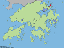


Double Island or Wong Wan Chau (Chinese: 往灣洲) is an island located in the north-eastern part of Hong Kong. Administratively, it is part of North District.
YouTube Encyclopedic
-
1/3Views:3 4311 4364 262
-
Crooked Island , Kat O , Hike Hong Kong
-
Crescent Island or Ngo Mei Chau, 娥眉洲,Hong Kong
-
I went to Hong Kong's Most Fascinating Abandoned Islands: The Soko Islands.
Transcription
Geography
Double Island has an area of 2.13 km².[1] It is the second largest island in North District, the largest being Crooked Island. Its highest point is at 139 m.[2] Its western coast is facing Double Haven.
Wong Wan (往灣) is a bay of Double Island. It is one of the 26 designated marine fish culture zones in Hong Kong.[3]
Conservation
Double Island became part of the Plover Cove (Extension) Country Park in 1979.[4]
Facilities
- Outward Bound Hong Kong Adventure Base
History
Typhoon of 1858
It is wrongly suggested that it was the Double Island in Hong Kong's Double Haven (Yan Chau Tong, 印洲塘) where the September Typhoon of 1858 destroyed several well-known opium clippers, including the Anonyma, Gazelle, Pantaloon, and Mazeppa. Basil Lubbock's The Opium Clippers, cited in the original entry, is quite clear (p.347) that the Double Island in question was that at what was then called Swatow (today Shantou). The island is one of two that lie in the entrance to the river at Shantou and is the inner one, then called Masu. Today it is called Mayu (媽嶼島). For corroboration see Mayers & Dennys,[5] for the identity of Double Island. For the typhoon and the damage to the vessels, The Courier (Hobart, Tasmania), 22 December 1858, p.3 for a report of Mr Midwood, of the Commissariat service, resident on Double Island during the typhoon.
See also
References
- ^ Survey and Mapping Office, Lands Department: Hong Kong geographic data sheet
- ^ "K.W. Lai, S.D.G. Campbell & R. Shaw, Geology of the Northeastern New Territories, p. 15, Civil Engineering Dept, Geotechnical Engineering Office, December 1996" (PDF). Archived from the original (PDF) on 12 March 2012. Retrieved 12 July 2011.
- ^ "Marine fish culture, pond fish culture and oyster culture". Fisheries Branch. Agriculture, Fisheries and Conservation Department. 12 August 2019. Retrieved 16 December 2019.
- ^ Agriculture, Fisheries and Conservation Department: Plover Cove Country Park
- ^ William Frederick Mayers and Nicholas Belfield Dennys, The Treaty Ports of China and Japan (Hong Kong: Shortrede, 1867), p.236
22°30′45″N 114°18′37″E / 22.51250°N 114.31028°E
This New Territories location article is a stub. You can help Wikipedia by expanding it. |