
Werl, Germany | |
|---|---|
 Wallfahrtsbasilika | |
 Coat of arms | |
Location of Werl, Germany within Soest district  | |
 Werl, Germany  Werl, Germany | |
| Coordinates: 51°33′0″N 7°55′12″E / 51.55000°N 7.92000°E | |
| Country | Germany |
| State | North Rhine-Westphalia |
| Admin. region | Arnsberg |
| District | Soest |
| Subdivisions | 10 |
| Government | |
| • Mayor (2020–25) | Torben Höbrink[1] (CDU) |
| Area | |
| • Total | 76.24 km2 (29.44 sq mi) |
| Highest elevation | 228 m (748 ft) |
| Lowest elevation | 73 m (240 ft) |
| Population (2021-12-31)[2] | |
| • Total | 30,736 |
| • Density | 400/km2 (1,000/sq mi) |
| Time zone | UTC+01:00 (CET) |
| • Summer (DST) | UTC+02:00 (CEST) |
| Postal codes | 59457 |
| Dialling codes | 02922 |
| Vehicle registration | SO |
| Website | www.werl.de |

Werl (German pronunciation: [vɛʁl] ⓘ; Westphalian: Wiärl) is a town located in the district of Soest in North Rhine-Westphalia, Germany.
YouTube Encyclopedic
-
1/4Views:1 35282 577981699
-
Germany: A short visit to the city of Werl
-
K1 Reportage_ Der Knast - Die Justizvollzugsanstalt Werl - Teil 2
-
Irish Folk Night and more 2014 - The Werl Pipes & Drums
-
Werl 2017 07 30
Transcription
Geography
Werl is easily accessible because it is located between the Sauerland, Münsterland, and the Ruhr Area. The Hellweg road runs through the city, as Werl is a part of the fertile Bördelandschaft of the Werl–Unnaer Börde.
Neighbouring municipalities
Division of the town
Werl consists of the following districts:
- Blumenthal (48 inhabitants)
- Budberg (596 inhabitants)
- Büderich (3107 inhabitants)
- Hilbeck (1339 inhabitants)
- Holtum (1049 inhabitants)
- Mawicke (521 inhabitants)
- Niederbergstraße (210 inhabitants)
- Oberbergstraße (363 inhabitants)
- Sönnern (870 inhabitants)
- Westönnen (2665 inhabitants)
- Werl (22151 inhabitants)
History
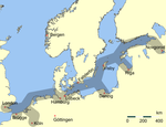
Werl was a member of the Hanseatic League in the Middle Ages and since 1661 has had a statue of the Virgin Mary, making it a place of pilgrimage. Today this relic is in the Wallfahrtsbasilika and is looked after by the Franciscan religious order. Werl Prison is the third largest in North Rhine-Westphalia, Werl Prison.
- The 4th United States Army Field Artillery Detachment was stationed in Werl until 1992.
Mayors
- 1958–1965: Ferdinand Pöppinghaus (1923–1965) (CDU)
- 1965–1981: Amalie Rohrer (1922-2014) (CDU)
- 1981–1985: Heinz Sasse (CDU)
- 1986–1994: Elisabeth Böhmer (CDU)
- 1994–1996: Kunibert Becker (1934-2001) (CDU)
- 1996–1999: Friedrich Leopold Graf von Brühl, (born 1944) (CDU)
- 1999–2020: Michael Grossmann, (born 1948) (CDU)
- since 2020: Torben Höbrink (CDU)
Notable people
- Philipp Rosenthal (1855–1937), businessman and founder of Rosenthal AG at Schloss Erkersreuth in Selb
- Franz von Papen (1879–1969), Conservative politician, diplomat, nobleman and General Staff officer; served as Chancellor of Germany in 1932 and as Vice-Chancellor under Adolf Hitler from 1933 to 1934
- Ulla Wiesner (born 1940), singer
- Theodor Redder (born 1941), footballer
- Dimitri Hegemann (born 1954), cultural manager, musician and founder of the club "Tresor" in Berlin
- Martin Kree (born 1965), footballer
- Uwe Grauer (born 1970), footballer and coach
Twin towns – sister cities
 Halle, Belgium (1973)
References
- ^ Wahlergebnisse in NRW Kommunalwahlen 2020, Land Nordrhein-Westfalen, accessed 30 June 2021.
- ^ "Bevölkerung der Gemeinden Nordrhein-Westfalens am 31. Dezember 2021" (in German). Landesbetrieb Information und Technik NRW. Retrieved 20 June 2022.
- ^ "Städtepartnerschaft mit der belgischen Stadt Halle". werl.de (in German). Werl. Retrieved 2021-02-17.
External links
- Official website
 (in German)
 - Images from Werl (in German)
Members of the Hanseatic League by quarter, and trading posts of the Hanseatic League | ||||
|---|---|---|---|---|
| ||||
| Wendish |
|   | ||
| Saxon | ||||
| Baltic | ||||
| Westphalian | ||||
| Kontore | ||||
| Vitten | ||||
| Factories | ||||
Towns and municipalities in Soest (district) | ||
|---|---|---|
 | ||
| International | |
|---|---|
| National | |
| Geographic | |
This Soest district location article is a stub. You can help Wikipedia by expanding it. |