
Watari
亘理町 | |
|---|---|
 Watari Town hall | |
 Flag  Seal | |
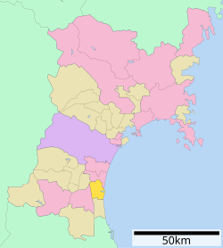 Location of Watari in Miyagi Prefecture | |
 Watari | |
| Coordinates: 38°02′16″N 140°51′9.3″E / 38.03778°N 140.852583°E | |
| Country | Japan |
| Region | Tōhoku |
| Prefecture | Miyagi |
| District | Watari |
| Area | |
| • Total | 73.60 km2 (28.42 sq mi) |
| Population (May 31, 2020) | |
| • Total | 33,459 |
| • Density | 450/km2 (1,200/sq mi) |
| Time zone | UTC+9 (Japan Standard Time) |
| Phone number | 0223-34-0502 |
| Address | 7-4 Shimokoji, Watari-chō, Watari-gun, Miyagi-ken 989-2393 |
| Climate | Cfa |
| Website | Official website |
| Symbols | |
| Flower | Camellia sasanqua |
| Tree | Pinus thunbergii |
Watari (亘理町, Watari-chō) is a town located in Miyagi Prefecture, Japan. As of 31 March 2020[update], the town had an estimated population of 33,459, and a population density of 450 persons per km2 in 12,643 households.[1] The total area of the town is 73.60 square kilometres (28.42 sq mi).
YouTube Encyclopedic
-
1/3Views:5977301 944
-
Watari, Miyagi Salmon Specialty: Harako-Meshi
-
Past Tsunami Inundation Road 20; Arahama of Watari, Miyagi JAPAN (4K Movie)
-
Minamisanriku, Miyagi, Japan October 2012 Tsunami Aftermath - GlobalMedic
Transcription
Geography
Watari is located in the Tōhoku region of northern Japan, in the southeastern Miyagi Prefecture, bordered by the Pacific Ocean to the east. The Abukuma River flows through the town, forming its western border.
Neighboring municipalities
Miyagi Prefecture
Climate
Watari has a humid climate (Köppen climate classification Cfa) characterized by mild summers and cold winters. The average annual temperature in Watari is 12.4 °C (54.3 °F). The average annual rainfall is 1,272.2 mm (50.09 in) with September as the wettest month. The temperatures are highest on average in August, at around 23.9 °C (75.0 °F), and lowest in January, at around 1.8 °C (35.2 °F).[2]
| Climate data for Watari (1991−2020 normals, extremes 1976−present) | |||||||||||||
|---|---|---|---|---|---|---|---|---|---|---|---|---|---|
| Month | Jan | Feb | Mar | Apr | May | Jun | Jul | Aug | Sep | Oct | Nov | Dec | Year |
| Record high °C (°F) | 17.4 (63.3) |
20.2 (68.4) |
25.2 (77.4) |
30.2 (86.4) |
30.8 (87.4) |
32.8 (91.0) |
36.1 (97.0) |
36.0 (96.8) |
34.4 (93.9) |
29.5 (85.1) |
26.1 (79.0) |
20.8 (69.4) |
36.1 (97.0) |
| Mean daily maximum °C (°F) | 6.1 (43.0) |
6.7 (44.1) |
10.1 (50.2) |
15.3 (59.5) |
19.7 (67.5) |
22.4 (72.3) |
25.8 (78.4) |
27.5 (81.5) |
24.6 (76.3) |
19.7 (67.5) |
14.3 (57.7) |
8.8 (47.8) |
16.8 (62.2) |
| Daily mean °C (°F) | 1.8 (35.2) |
2.2 (36.0) |
5.2 (41.4) |
10.3 (50.5) |
15.2 (59.4) |
18.7 (65.7) |
22.4 (72.3) |
23.9 (75.0) |
20.6 (69.1) |
15.2 (59.4) |
9.4 (48.9) |
4.3 (39.7) |
12.4 (54.4) |
| Mean daily minimum °C (°F) | −2.5 (27.5) |
−2.3 (27.9) |
0.3 (32.5) |
5.2 (41.4) |
11.0 (51.8) |
15.6 (60.1) |
19.7 (67.5) |
21.0 (69.8) |
17.2 (63.0) |
11.1 (52.0) |
4.6 (40.3) |
−0.1 (31.8) |
8.4 (47.1) |
| Record low °C (°F) | −13.0 (8.6) |
−11.6 (11.1) |
−6.4 (20.5) |
−4.9 (23.2) |
2.9 (37.2) |
7.9 (46.2) |
12.3 (54.1) |
12.7 (54.9) |
7.7 (45.9) |
0.9 (33.6) |
−3.8 (25.2) |
−7.3 (18.9) |
−13.0 (8.6) |
| Average precipitation mm (inches) | 45.3 (1.78) |
33.3 (1.31) |
71.7 (2.82) |
86.6 (3.41) |
104.7 (4.12) |
133.1 (5.24) |
180.7 (7.11) |
154.9 (6.10) |
202.6 (7.98) |
164.0 (6.46) |
58.0 (2.28) |
37.3 (1.47) |
1,272.2 (50.09) |
| Average precipitation days (≥ 1.0 mm) | 5.3 | 5.1 | 7.7 | 8.1 | 9.4 | 11.7 | 13.8 | 11.5 | 12.1 | 8.8 | 5.8 | 5.5 | 104.8 |
| Mean monthly sunshine hours | 153.2 | 158.2 | 183.4 | 190.6 | 190.1 | 146.0 | 132.9 | 155.9 | 131.2 | 144.9 | 145.5 | 146.4 | 1,881.1 |
| Source: Japan Meteorological Agency[3][2] | |||||||||||||
Demographics
Per Japanese census data,[4] the population of Watari has remained relatively steady since the turn of the 21st century.
| Year | Pop. | ±% |
|---|---|---|
| 1920 | 17,791 | — |
| 1930 | 20,606 | +15.8% |
| 1940 | 21,262 | +3.2% |
| 1950 | 28,939 | +36.1% |
| 1960 | 27,277 | −5.7% |
| 1970 | 25,141 | −7.8% |
| 1980 | 27,822 | +10.7% |
| 1990 | 30,301 | +8.9% |
| 2000 | 34,770 | +14.7% |
| 2010 | 34,854 | +0.2% |
| 2020 | 33,087 | −5.1% |
History
The area of present-day Watari was part of ancient Mutsu Province, and the place name of “Watari” appears in the Shoku Nihongi chronicles dated 718 AD. It was part of the holdings of Sendai Domain under the Edo period Tokugawa shogunate.
Watari Town was established on April 1, 1889 with the establishment of the post-Meiji restoration modern municipalities system. It merged with the neighboring town of Arahama and villages of Yoshida and Õkuma on February 1, 1955.
Watari was severely damaged by a tsunami caused by an earthquake on 11 March 2011.[5] Hundreds of people were stranded in a school but were airlifted from the roof by Japanese military helicopters.[6] The tsunami covered 47% of the town's area and 305 residents were reported killed or missing.
Government
Watari has a mayor-council form of government with a directly elected mayor and a unicameral town council of 18 members. Watari contributes one seat to the Miyagi Prefectural legislature. In terms of national politics, the town is part of Miyagi 3rd district of the lower house of the Diet of Japan.
Economy
The economy of Watari is largely based on agriculture (strawberries) and commercial fishing and fish processing.
Education
Watari has six public elementary schools and four public middle schools operated by the town government, and one public high school operated by the Miyagi Prefectural Board of Education.
Transportation
Railway
![]() East Japan Railway Company (JR East) - Jōban Line
East Japan Railway Company (JR East) - Jōban Line
- Hamayoshida - Watari - Ōkuma
Highway
 Jōban Expressway – Torinoumi Interchange and Parking Area – Watari Interchange
- Sendai-Tōbu Road – Watari Interchange
 National Route 6
Local attractions
- Sanjūsangendō Kanga ruins, Heian period National Historic Site[7]
- Watari Jinja (site of Watari Castle)
References
- ^ Watari Town official statistics (in Japanese)
- ^ a b 気象庁 / 平年値(年・月ごとの値). JMA. Retrieved March 22, 2022.
- ^ 観測史上1~10位の値(年間を通じての値). JMA. Retrieved March 22, 2022.
- ^ Watari population statistics
- ^ Grossman, Cathy Lynn (15 March 2011). "Japanese look to ancient traditions for strength". USA Today. Retrieved 19 March 2011.
- ^ Zeitvogel, Karin (19 March 2011). "Japan quake: live report". AFP/Google. Archived from the original on March 17, 2011. Retrieved 19 March 2011.
- ^ "三十三間堂官衙遺跡". Cultural Heritage Online (in Japanese). Agency for Cultural Affairs. Retrieved 25 December 2016.
External links
![]() Media related to Watari, Miyagi at Wikimedia Commons
Media related to Watari, Miyagi at Wikimedia Commons
- Official Website (in Japanese)
| Sendai |
| ||
|---|---|---|---|
| Cities | |||
| Districts | |||
| International | |
|---|---|
| National | |
| Geographic | |