To install click the Add extension button. That's it.

The source code for the WIKI 2 extension is being checked by specialists of the Mozilla Foundation, Google, and Apple. You could also do it yourself at any point in time.

4,5
Kelly Slayton
Congratulations on this excellent venture… what a great idea!
Alexander Grigorievskiy
I use WIKI 2 every day and almost forgot how the original Wikipedia looks like.
Live Statistics
English Articles
Improved in 24 Hours
Added in 24 Hours
Languages
Recent
Show all languages
What we do. Every page goes through several hundred of perfecting techniques; in live mode. Quite the same Wikipedia. Just better.
.
Leo
Newton
Brights
Milds

From Wikipedia, the free encyclopedia

Voda, Kansas
KDOT map of Trego County (legend)
Voda is located in Kansas
Voda
Voda
Voda is located in the United States
Voda
Voda
Coordinates: 39°2′57″N 100°1′11″W / 39.04917°N 100.01972°W / 39.04917; -100.01972[1]
CountryUnited States
StateKansas
CountyTrego
Elevation2,549 ft (777 m)
Time zoneUTC-6 (CST)
 • Summer (DST)UTC-5 (CDT)
Area code785
FIPS code20-74125 [1]
GNIS ID471360 [1]

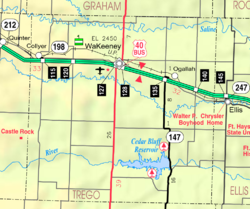
Voda is an unincorporated community in Trego County, Kansas, United States.[1] It is located approximately 7 miles west of WaKeeney.

History

A post office in Voda opened in 1904, closed in 1907, reopened in 1912, and closed permanently in 1913.[2]

References

  1. ^ a b c d e "Voda, Kansas", Geographic Names Information System, United States Geological Survey, United States Department of the Interior
  2. ^ "Kansas Post Offices, 1828-1961". Kansas Historical Society. Archived from the original on October 9, 2013. Retrieved June 27, 2014.

Further reading

External links


This page was last edited on 29 July 2023, at 16:26
Basis of this page is in Wikipedia. Text is available under the CC BY-SA 3.0 Unported License. Non-text media are available under their specified licenses. Wikipedia® is a registered trademark of the Wikimedia Foundation, Inc. WIKI 2 is an independent company and has no affiliation with Wikimedia Foundation.