
Union Township | |
|---|---|
 Mount Zion Methodist Church, a historic site in the township | |
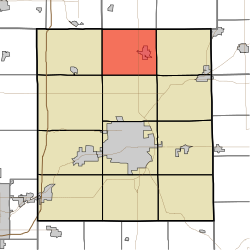 Location of Union Township in Delaware County | |
| Coordinates: 40°20′53″N 85°23′03″W / 40.34806°N 85.38417°W | |
| Country | United States |
| State | Indiana |
| County | Delaware |
| Government | |
| • Type | Indiana township |
| Area | |
| • Total | 29.65 sq mi (76.8 km2) |
| • Land | 29.34 sq mi (76.0 km2) |
| • Water | 0.3 sq mi (0.8 km2) |
| Elevation | 899 ft (274 m) |
| Population | |
| • Total | 2,540 |
| • Density | 96.7/sq mi (37.3/km2) |
| FIPS code | 18-77246[3] |
| GNIS feature ID | 453913 |
Union Township is one of twelve townships in Delaware County, Indiana. According to the 2010 census, its population was 2,838 and it contained 1,260 housing units.[4]
YouTube Encyclopedic
-
1/3Views:1 665524677
-
Abandoned Huntingdon & Broadtop RR and Juniata Canal, Huntington, PA
-
John Makar - The Harmony Line
-
Old Alignment - The Northern Turnpike AKA Northern Pike, Wilkins, PA
Transcription
History
Felt's Farm and the Mount Zion Methodist Episcopal Church are listed on the National Register of Historic Places.[5]
Geography
According to the 2010 census, the township has a total area of 29.65 square miles (76.8 km2), of which 29.34 square miles (76.0 km2) (or 98.95%) is land and 0.3 square miles (0.78 km2) (or 1.01%) is water.[4]
Cities and towns
Unincorporated towns
(This list is based on USGS data and may include former settlements.)
Adjacent townships
- Licking Township, Blackford County (north)
- Jackson Township, Blackford County (northeast)
- Niles Township (east)
- Delaware Township (southeast)
- Hamilton Township (south)
- Harrison Township (southwest)
- Washington Township (west)
Major highways
Cemeteries
The township contains three cemeteries: Leaird, Mount Zion Church and Union.
References
- ^ "US Board on Geographic Names". United States Geological Survey. October 25, 2007. Retrieved January 31, 2008.
- ^ "Census Bureau profile: Union Township, Delaware County, Indiana". United States Census Bureau. May 2023. Retrieved March 18, 2024.
- ^ "U.S. Census website". United States Census Bureau. Retrieved January 31, 2008.
- ^ a b "Population, Housing Units, Area, and Density: 2010 - State -- County Subdivision -- 2010 Census Summary File 1". United States Census. Archived from the original on February 12, 2020. Retrieved May 10, 2013.
- ^ "National Register Information System". National Register of Historic Places. National Park Service. July 9, 2010.
External links
Wikimedia Commons has media related to Union Township, Delaware County, Indiana.
Municipalities and communities of Delaware County, Indiana, United States | ||
|---|---|---|
| City |  | |
| Towns | ||
| Townships | ||
| CDPs | ||
| Other communities | ||
| Footnotes | ‡This populated place also has portions in an adjacent county or counties | |