
Umatilla Indian Reservation | |
|---|---|
| Tribe | Confederated Tribes of the Umatilla Indian Reservation |
| Country | United States |
| State | Oregon |
| County | Umatilla and Union |
| Headquarters | Mission |
| Area | |
| • Total | 702.01 km2 (271.047 sq mi) |
| Website | Confederated Tribes of the Umatilla Indian Reservation |


The Umatilla Indian Reservation is an Indian reservation in the Pacific Northwest of the United States. It was created by The Treaty of 9 June 1855 between the United States and members of the Walla, Cayuse, and Umatilla tribes. It lies in northeastern Oregon, east of Pendleton. The reservation is mostly in Umatilla County, with a very small part extending south into Union County. It is managed by the three Confederated Tribes of the Umatilla Indian Reservation.
Located on the north side of the Blue Mountains, the reservation was established for two Sahaptin-speaking Native American tribes: the Umatilla and Walla Walla, and for the Cayuse, whose language, now extinct, was an isolate. All the tribes historically inhabited the Columbia Plateau region. The tribes share land and a governmental structure as part of their confederation.
YouTube Encyclopedic
-
1/5Views:4483 4933 5531 942517 786
-
AgSci Alum Lauren Lewis, Confederated Tribes of the Umatilla Indian Reservation
-
The Umatilla People: Oregon & Washington - Sahaptin Culture, History & Affiliations
-
Liksiyu: The Cayuse People - Confederated Tribes Of The Umatilla Indian Reservation
-
Listen for Life: Confederated Tribes of Umatilla Indian Reservation
-
Native American reservations explained
Transcription
Geography, demographics and headquarters

The reservation has a land area of 271.047 square miles (702.01 km2) and a tribal population of 2,927 as of the 2000 census. In addition, some 300 Native Americans from other regional tribes and 1,500 non-natives live on the reservation.[1] The largest community is Mission, which is the site of the tribal headquarters as well as the Umatilla Agency of the Bureau of Indian Affairs.[2][3] Some BIA agency offices serve more than one federally recognized tribe, but the Umatilla Agency exclusively serves the Confederated Tribes of the Umatilla Indian Reservation (CTUIR).[4]
The CTUIR is one of several tribal governments in the northwestern United States to offer free bus service on its reservation.[5]
History
The tribes developed the Wildhorse Casino Resort on their reservation to generate revenues for their people. The casino is located near Interstate 84. In 2006 it started Cayuse Technologies, to provide software development and related services. These enterprises employ 1,000 persons and have markedly reduced unemployment.
Pendleton photographer Walter S. Bowman photographed tribe members in the early 20th century.[6][7][8] The CTUIR founded the Tamástslikt Cultural Institute, a museum that provides both historical and contemporary exhibits related to the confederated tribes, as well as exhibits of contemporary Native American arts and traditional craftwork.
Communities

See also
- Henry Roe Cloud, Superintendent, Umatilla Indian Reservation
- Shoni Schimmel, WNBA player born and raised on the reservation until leaving with her family while in high school
References
- ^ "Who We Are" (January 2013) Archived 27 January 2012 at the Wayback Machine, Confederated Tribes of the Umatilla Reservation
- ^ "Indian Agency Headquarters". Geographic Names Information System. United States Geological Survey, United States Department of the Interior. 28 November 2009. Retrieved 23 December 2009.
- ^ "Umatilla Agency". Retrieved 23 December 2009.
- ^ "Northwest Region - Tribes Served". Bureau of Indian Affairs. Retrieved 23 December 2009.
- ^ https://indigenousgov.hks.harvard.edu/publications/ctuir-public-transit-confederated-tribes-umatilla-indian-reservation
- ^ "CONTENTdm Collection : Item Viewer". Archived from the original on 19 October 2013. Retrieved 29 March 2020.
- ^ "W.S. Bowman photographs, 1890-1925". Archived from the original on 2 April 2016. Retrieved 30 January 2024.
- ^ "Walter S. Bowman Photographs". Archived from the original on 15 February 2015. Retrieved 30 January 2024.
External links
- Umatilla Reservation, Oregon United States Census Bureau
- Historical National Park Service photos from Umatilla Indian Reservation
- A middle-aged man reflects on his life at the Umatilla reservation
45°42′N 118°30′W / 45.7°N 118.5°W
Municipalities and communities of Umatilla County, Oregon, United States | ||
|---|---|---|
| Cities |  | |
| CDPs | ||
| Other communities | ||
| Indian reservation | ||
| Ghost towns | ||
Municipalities and communities of Union County, Oregon, United States | ||
|---|---|---|
| Cities | 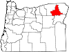 | |
| Unincorporated communities | ||
| Indian reservation | ||
| Ghost town | ||
| International | |
|---|---|
| National | |
| Other | |