
Teasdale, Utah | |
|---|---|
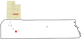 Location in Wayne County and the state of Utah. | |
| Coordinates: 38°17′04″N 111°28′23″W / 38.28444°N 111.47306°W | |
| Country | United States |
| State | Utah |
| County | Wayne |
| Settled | 1878 |
| Named for | George Teasdale |
| Area | |
| • Total | 4.0 sq mi (10.4 km2) |
| • Land | 4.0 sq mi (10.4 km2) |
| • Water | 0 sq mi (0 km2) |
| Elevation | 7,103 ft (2,165 m) |
| Population | |
| • Total | 191 |
| • Density | 48/sq mi (18.4/km2) |
| Time zone | UTC-7 (Mountain (MST)) |
| • Summer (DST) | UTC-6 (MDT) |
| ZIP code | 84773 |
| Area code | 435 |
| FIPS code | 49-75470 |
| GNIS feature ID | 2629955[1] |
Teasdale is a census-designated place in western Wayne County, Utah, United States, between the Dixie and Fishlake National Forests and near Capitol Reef National Park. The population was 191 at the 2010 census. Teasdale lies along local roads south of State Route 24, southeast of the town of Loa, the county seat of Wayne County.[3] Teasdale has a post office with the ZIP code 84773.[4]
YouTube Encyclopedic
-
1/3Views:1 4921 23461 625
-
Blind Lake,Utah Boulder Mountain Wilderness
-
Sulphur Creek Flash Flood, Wayne County, Utah
-
HUGE Flash Flood, Southern Utah September 11, 2013
Transcription
History
The town was founded by LDS settlers. They called it Bullberry Creek named after the creek adjacent to the town. In the early 1900s, the community was named for George Teasdale, a member of the Quorum of the Twelve Apostles of The Church of Jesus Christ of Latter-day Saints (LDS Church).[5]
Demographics
As of the census[2] of 2010, there were 191 people living in the CDP. There were 123 housing units. The racial makeup of the town was 95.3% White, 2.6% American Indian and Alaska Native, 1.0% Asian, 0.5% Native Hawaiian and Other Pacific Islander, and 0.5% from two or more races. Hispanic or Latino of any race were 1.6% of the population.
Climate
According to the Köppen Climate Classification system, Teasdale has a semi-arid climate, abbreviated "BSk" on climate maps.[6]
See also
References
- ^ a b "Teasdale, Utah". Geographic Names Information System. United States Geological Survey, United States Department of the Interior. Retrieved May 23, 2011.
- ^ a b "U.S. Census website". United States Census Bureau. Retrieved May 23, 2011.
- ^ Rand McNally. The Road Atlas '08. Chicago: Rand McNally, 2008, p. 102.
- ^ USPS – Cities by ZIP Code
- ^ Jenson, Andrew (August 8, 1891). "In Rabbit Valley". Deseret News. p. 195. Retrieved April 23, 2015.
- ^ Climate Summary for Teasdale, Utah
External links
![]() Media related to Teasdale, Utah at Wikimedia Commons
Media related to Teasdale, Utah at Wikimedia Commons
Municipalities and communities of Wayne County, Utah, United States | ||
|---|---|---|
| Towns | 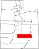 | |
| CDPs | ||
| Unincorporated communities | ||
| Ghost towns | ||
| International | |
|---|---|
| National | |
This article about a location in Utah is a stub. You can help Wikipedia by expanding it. |