
| South Fork New River | |
|---|---|
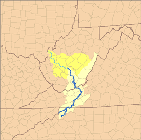 Map of the Kanawha River watershed, with the New River and its watershed highlighted. | |
| Location | |
| Country | United States |
| State | North Carolina |
| Counties | Watauga, Alleghany, Ashe |
| Physical characteristics | |
| Source | Middle Fork South Fork New River |
| • location | Blowing Rock, NC |
| • coordinates | 36°07′34″N 81°40′20″W / 36.12611°N 81.67222°W |
| • elevation | 3,543 ft (1,080 m) |
| 2nd source | East Fork South Fork New River |
| • location | Watauga County, NC |
| • coordinates | 36°10′56″N 81°36′37″W / 36.18222°N 81.61028°W |
| • elevation | 3,271 ft (997 m) |
| Source confluence | |
| • location | Boone, NC |
| • coordinates | 36°12′16″N 81°38′59″W / 36.20444°N 81.64972°W |
| • elevation | 3,104 ft (946 m) |
| Mouth | New River[1] |
• location | Ashe County, NC |
• coordinates | 36°32′46″N 81°21′11″W / 36.54611°N 81.35306°W |
• elevation | 2,546 ft (776 m) |
| Discharge | |
| • location | Jefferson, NC[2] |
| • average | 552 cu ft/s (15.6 m3/s) |
| • minimum | 227 cu ft/s (6.4 m3/s)(1986) |
| • maximum | 2,120 cu ft/s (60 m3/s)(1998) |
The South Fork New River is a river in the U.S. state of North Carolina.
It stretches from its headwaters at a spring near Blowing Rock and the Eastern Continental Divide and meanders northward along the northwestern face of the Blue Ridge Mountains through the eastern and central portions of Watauga County and then Ashe County in northwestern North Carolina, passing through the town of Boone. It joins the North Fork New River in Ashe County to form the New River. Its waters ultimately reach the Gulf of Mexico through the Kanawha River, the Ohio River, and the Mississippi River. Its tributaries include Winkler's Creek, Boone (Kraut) Creek and Payne Branch.
YouTube Encyclopedic
-
1/3Views:14 1221 8177 624
-
New River Outfitters Canoeing Kayaking Tubing on the New River in North Carolina
-
New River (Day Group Paddle) May 2014
-
New River State Park | NC Weekend | UNC-TV
Transcription
Middle Fork
The Middle Fork runs between the towns of Blowing Rock and Boone and is fed by tributaries including the Aho Branch Creek (AY-ho). Due to industrial usage and highway widening projects in the 1970s, much of the Middle Fork was severely ecologically degraded. Since 2000, the Middle Fork Greenway project has been working to create a 6.5-mile recreational greenway between the two cities. Additionally, work is being done to restore native plants and damaged sections of the river.[3]
See also
References
- ^ U.S. Geological Survey Geographic Names Information System: South Fork New River
- ^ United States Geological Survey; USGS 03161000 SOUTH FORK NEW RIVER NEAR JEFFERSON, NC; retrieved April 19, 2008.
- ^ "Middle Fork Greenway, A Blue Ridge Conservancy Project". Retrieved June 5, 2022.