
Si That
ศรีธาตุ | |
|---|---|
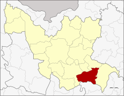 District location in Udon Thani province | |
| Coordinates: 16°58′22″N 103°13′0″E / 16.97278°N 103.21667°E | |
| Country | Thailand |
| Province | Udon Thani |
| Seat | Si That |
| Area | |
| • Total | 512.5 km2 (197.9 sq mi) |
| Population (2005) | |
| • Total | 47,888 |
| • Density | 93.4/km2 (242/sq mi) |
| Time zone | UTC+7 (ICT) |
| Postal code | 41230 |
| Geocode | 4109 |
Si That (Thai: ศรีธาตุ, pronounced [sǐː tʰâːt]) is a district (amphoe) in the southeastern Udon Thani province, northeastern Thailand.
Geography
Neighboring districts are (from the west clockwise) Kumphawapi, Ku Kaeo, Chai Wan and Wang Sam Mo of Udon Thani Province, and Tha Khantho of Kalasin province.
History
The minor district (king amphoe) Si That was created on 1 March 1968 by splitting off the five tambons Champi, Na Yung, Nong Ya Sai, Ban Prong, and Nong Kung Thap Ma from Kumphawapi district.[1] It was upgraded to a full district on 28 June 1973.[2]
Administration
The district is divided into seven sub-districts (tambons), which are further subdivided into 81 villages (mubans). Si That is a township (thesaban tambon) which covers parts of tambon Si That. There are a further seven tambon administrative organizations (TAO).
| No. | Name | Thai name | Villages | Pop. | |
|---|---|---|---|---|---|
| 1. | Si That | ศรีธาตุ | 11 | 8,193 | |
| 2. | Champi | จำปี | 17 | 7,977 | |
| 3. | Ban Prong | บ้านโปร่ง | 11 | 5,549 | |
| 4. | Hua Na Kham | หัวนาคำ | 14 | 10,602 | |
| 5. | Nong Nok Khian | หนองนกเขียน | 7 | 4,445 | |
| 6. | Na Yung | นายูง | 10 | 5,069 | |
| 7. | Tat Thong | ตาดทอง | 11 | 6,053 |
References
- ^ ประกาศกระทรวงมหาดไทย เรื่อง แบ่งท้องที่ตั้งเป็นกิ่งอำเภอ (PDF). Royal Gazette (in Thai). 85 (24 ง): 798. March 12, 1968. Archived from the original (PDF) on March 24, 2012.
- ^ พระราชกฤษฎีกาตั้งอำเภอเขาพนม อำเภอสนามชัยเขต อำเภอแม่อาย อำเภอขามสะแกแสง อำเภอเก้าเลี้ยว อำเภอโพธิ์ประทับช้าง อำเภอหนองพอก อำเภอละอุ่น อำเภอทุ่งหว้า และอำเภอศรีธาตุ พ.ศ. ๒๕๑๖ (PDF). Royal Gazette (in Thai). 90 (75 ก special): 32–36. June 28, 1973. Archived from the original (PDF) on February 24, 2012.
External links
This Udon Thani Province location article is a stub. You can help Wikipedia by expanding it. |