Saint-Pierre | |
|---|---|
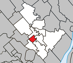
 Location within Joliette RCM. | |
| Coordinates: 46°01′N 73°28′W / 46.017°N 73.467°W[1] | |
| Country | |
| Province | |
| Region | Lanaudière |
| RCM | Joliette |
| Constituted | April 24, 1922 |
| Named for | Saint Peter[1] |
| Government | |
| • Mayor | Roland Charest |
| • Federal riding | Joliette |
| • Prov. riding | Joliette |
| Area | |
| • Total | 10.10 km2 (3.90 sq mi) |
| • Land | 9.68 km2 (3.74 sq mi) |
| Population (2021)[3] | |
| • Total | 286 |
| • Density | 29.5/km2 (76/sq mi) |
| • Pop 2016-2021 | |
| • Dwellings | 132 |
| Time zone | UTC−5 (EST) |
| • Summer (DST) | UTC−4 (EDT) |
| Postal code(s) | |
| Area code(s) | 450 and 579 |
| Highways | |
Saint-Pierre (French pronunciation: [sɛ̃ pjɛʁ] ⓘ) is a village municipality in Joliette Regional County Municipality in the Lanaudière region of Quebec, Canada.
YouTube Encyclopedic
-
1/5Views:3274 303457272 7003 485
-
Havre St Pierre & Mingan Archipelago, Quebec
-
Top 10 Best Hotels in Quebec, Canada
-
Mont-Saint-Pierre Haute-Gaspésie Quebec (Canada)
-
🇨🇦 Qué ver en QUEBEC, la ciudad más bella de Canadá
-
Mont St-Pierre - Mont Louis - La Martre - Pointe-à-la-Renommée - Haute Gaspésie - Québec - Canada
Transcription
Demographics
In the 2021 Census of Population conducted by Statistics Canada, Saint-Pierre had a population of 286 living in 129 of its 132 total private dwellings, a change of 3.6% from its 2016 population of 276. With a land area of 9.68 km2 (3.74 sq mi), it had a population density of 29.5/km2 (76.5/sq mi) in 2021.[4]
Population:[5]
- Population in 2021: 286 (2016 to 2021 population change: 3.6%)
- Population in 2016: 276 (2011 to 2016 population change: -9.5%)
- Population in 2011: 305 (2006 to 2011 population change: 0.3%)
- Population in 2006: 304
- Population in 2001: 293
- Population in 1996: 357
- Population in 1991: 358
- Population in 1986: 386
- Population in 1981: 366
- Population in 1976: 341
- Population in 1971: 357
- Population in 1966: 354
- Population in 1961: 364
- Population in 1956: 350
- Population in 1951: 301
- Population in 1941: 311
- Population in 1931: 272
Mother tongue:
- English as first language: 1.8%
- French as first language: 94.7%
- English and French as first language: 0%
- Other as first language: 3.5%
Education
The Sir Wilfrid Laurier School Board operates anglophone public schools, including:
- Joliette Elementary School in Saint-Charles-Borromée[6]
- Joliette High School in Joliette[7]
See also
References
- ^ a b "Banque de noms de lieux du Québec: Reference number 57509". toponymie.gouv.qc.ca (in French). Commission de toponymie du Québec.
- ^ a b "Répertoire des municipalités: Geographic code 61020". www.mamh.gouv.qc.ca (in French). Ministère des Affaires municipales et de l'Habitation.
- ^ a b Statistics Canada 2021 Census - Saint-Pierre census profile
- ^ "Population and dwelling counts: Canada, provinces and territories, and census subdivisions (municipalities), Quebec". Statistics Canada. February 9, 2022. Retrieved August 28, 2022.
- ^ Statistics Canada: 1996, 2001, 2006, 2011, 2016, 2021 census
- ^ "JOLIETTE ELEMENTARY ZONE." Sir Wilfrid Laurier School Board. Retrieved on September 17, 2017.
- ^ "Joliette High School Zone Sec 1-5." Sir Wilfrid Laurier School Board. Retrieved on September 5, 2017.

