
Rob Roy Island, native name Velaviru, is an island in Solomon Islands located off the South East coast of Choiseul Island; it is located in Choiseul Province.[1][2]
YouTube Encyclopedic
-
1/3Views:4 7971 8695 245
-
Rob Roy Glacier & Roy's Peak - Living a Kiwi Life - Ep. 56
-
Rob Roy Glacier Track
-
Rob Roy MacGregor's secret cave.
Transcription
Geography
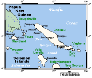
The island is covered with coconut plantation and jungle. The island is 20 km long and has a summit elevation of 150 m.[3]
Nagosele Passage divides Rob Roy Island from Choiseul Island[4][5][6][7]
References
- ^ "Rob Roy Island: Solomon Islands". Geographic Names. Retrieved 4 August 2018.
- ^ "Traveling Luck for Rob Roy Island". Traveling Luck. Retrieved 4 August 2018.
- ^ http://www.solomonislands.com.sb/robroy.html googlecached version of website
- ^ Excursion to Choiseul - Chapter Six — Page 53, Nagosele Passage, dividing Rob Roy Island from Choiseul, is in places less than 70 yards wide. Rob Roy rises steep from its waters, inaccessibly steep generally, but on the Choiseul side of the channel merges into shallow mangroved waters, providing hundreds of natural hideouts for small craft., Stepping Stones to the Solomons: the unofficial history of the 29th Battalion with the Second New Zealand Expeditionary Force in the Pacific., NZETC
- ^ Nggosele Passage between Choiseul and Rob Roy Island experiences strong currents depending on the tides. Archived 2008-09-19 at the Wayback Machine, South East Choiseul and Vaghena, choiseul, Exploring Solomons
- ^ Going through the passage between Rob Roy Island and Choiseul, May 12, 2009, by alan70, Panoramio
- ^ "Going through the passage between Rob Roy Island and Choiseul". Geoview. Retrieved 4 August 2018.
- Notes
- Rob Roy - Bird Checklists for 440 Melanesian Islands
7°25′S 157°35′E / 7.417°S 157.583°E
This Solomon Islands location article is a stub. You can help Wikipedia by expanding it. |