
Temotu Province | |
|---|---|
 Flag | |
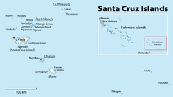 Map of the Temotu province | |
 | |
| Coordinates: 10°45′S 167°0′E / 10.750°S 167.000°E | |
| Country | |
| Capital | Lata |
| Government | |
| • Premier | Clay Forau[1] |
| Area | |
| • Total | 895 km2 (346 sq mi) |
| Population (2009[2]) | |
| • Total | 21,362 |
| • Density | 23.9/km2 (62/sq mi) |
| Time zone | UTC+11 (+11) |
Temotu (or Te Motu, literally "the island" in Polynesian) is the easternmost province of Solomon Islands. The province was formerly known as Santa Cruz Islands Province. It consists, essentially, of two chains of islands which run parallel to each other from the northwest to the southeast. Its area is 895 square kilometres (346 square miles).
YouTube Encyclopedic
-
1/3Views:1 8233 179952
-
Tinakula is a conical stratovolcano , Temotu Province, Solomon Islands
-
Solomon Islands Temotu Province
-
Temotu Neo Island 1994
Transcription
Administrative divisions
Temotu Province is sub-divided into the following wards:
Temotu Province (pop 21,362)
- Reef Islands
- Polynesian Outer Islands (353)
- Fenualoa (1,305)
- Nipua/Nopoli (880)
- Lipe/Temua (796)
- Manuopo (1,030)
- Nenumpo (1,163)
- Santa Cruz Islands
- Graciosa Bay (1,264)
- North East Santa Cruz (1,843)
- Nanggu/Lord Howe (1,863)
- Nea/Noole (1,770)
- Nevenema (947)
- Luva Station (2,335)
- Neo (1,558)
- isolated islands and groups
- Duff Islands (509)
- Utupua (1,168)
- Vanikoro (1,293)
- Tikopia (1,285)
Islands
The islands or island groups which make up the province are:
- Anuta
- Duff Islands (including Taumako)
- Fatutaka
- Malo
- Reef Islands (including Fenualoa, Lomlom, Makalom, Matema, Nalongo and Nupani, Nifiloli, Nukapu, Patteson Shoal, Pigeon Island and Pileni)
- Santa Cruz Islands (including the large island Nendö)
- Tikopia
- Tinakula
- Utupua
- Vanikoro (including Banie and Teanu)
The provincial capital is Lata, located on Nendö, the largest and most important of the Santa Cruz islands.
Population

The population of 21,362 (2009)[2] is quite diverse for the small land area encompassed. The Santa Cruz Islanders are predominantly Melanesian, although the inhabitants of Tikopia, Anuta, the Duff Islands and some of the Reef Islands are Polynesians.
Languages
The province has given its name to the Temotu languages, a putative linguistic subgroup within the broader Oceanic family of languages.
The languages spoken in the province include all nine Temotu languages proper, plus two Polynesian outlier languages: Vaeakau-Taumako and Tikopia.
See also
- Remote Oceania
- Koch, Gerd (1971). Die Materielle Kultur der Santa Cruz-Inseln (in German). Berlin: (Museum fur Volkerkunde) Ethnological Museum of Berlin.
References
- ^ "Solomon Islands Provinces".
- ^ a b Report on 2009 population & housing census for the Solomon Islands.
External links
| ||
10°45′S 167°00′E / 10.750°S 167.000°E
This Solomon Islands location article is a stub. You can help Wikipedia by expanding it. |