
| Prahova | |
|---|---|
 The Prahova near Adâncata | |
 | |
| Location | |
| Country | Romania |
| Counties | Brașov, Prahova, Ialomița |
| Towns | Bușteni, Sinaia, Comarnic, Breaza, Câmpina |
| Physical characteristics | |
| Source | Predeal |
| • coordinates | 45°30′30″N 25°34′32″E / 45.50833°N 25.57556°E |
| • elevation | 1,037 m (3,402 ft) |
| Mouth | Ialomița |
• location | Patru Frați |
• coordinates | 44°42′55″N 26°28′14″E / 44.71528°N 26.47056°E |
• elevation | 63 m (207 ft) |
| Length | 193 km (120 mi) |
| Basin size | 3,738 km2 (1,443 sq mi) |
| Discharge | |
| • location | * |
| • average | 28.3 m3/s (1,000 cu ft/s) |
| Basin features | |
| Progression | Ialomița→ Danube→ Black Sea |
| Tributaries | |
| • left | Doftana, Teleajen, Cricovul Sărat |
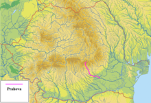
The Prahova is a river of Southern Romania, which rises from the Bucegi Mountains, in the Southern Carpathians. It is a left tributary of the Ialomița.[1][2] It flows into the Ialomița in Dridu Snagov.[3] The upper reach of the river, upstream of the confluence with the river Azuga is sometimes called the Prahovița.
It has a length of 193 km (120 mi),[2][4] of which 6 km (3.7 mi) are in Brașov County, 161 km (100 mi) are in Prahova County and the last 16 km (9.9 mi) are in Ialomița County.
The basin of the Prahova covers 3,738 km2 (1,443 sq mi),[2][4] which is about 75% of the area of Prahova County.
YouTube Encyclopedic
-
1/3Views:3851 293422
-
raul Prahova
-
Trenuri valea Prahovei / Trains prahova river
-
Driving through Sinaia, Prahova Valley Romania - 2017 09 18 - Samsung Gear 360 2017 camera
Transcription
Towns and villages
The following towns and villages are situated along the river Prahova, from source to mouth: Predeal, Azuga, Bușteni, Poiana Țapului, Sinaia, Posada, Comarnic, Nistorești, Breaza, Cornu, Poiana Câmpina, Câmpina, Bănești, Bobolia, Cocorăștii Caplii, Cap Roșu, Novăcești, Florești, Călinești, Cătina, Filipeștii de Târg, Nedelea, Ariceștii Rahtivani, Ezeni, Zalhanaua, Stăncești, Piatra, Stejaru, Pisculești, Tinosu, Miroslăvești, Palanca, Independența, Belciug, Gherghița, Hătcărău, Tufani, Malamuc, Răsimnicea, Rădulești, Adâncata, Patru Frați.
Tributaries
The following rivers are tributaries to the river Prahova (from source to mouth):[2]
- Left: Puriștoaca, Valea Popii, Olăreasa, Pârâul lui Vlad, Ursoaia Mare, Ursoaia Mică, Azuga, Valea Mărului (I), Valea Seacă (I), Valea Fetei, Valea Seacă (II), Valea Măturarului, Zamora, Șipa, Tufa, Valea Cășăriei (I), Valea Rea, Valea Câinelui, Gagu, Valea lui Bogdan, Valea la Nuci, Valea Mărului (II), Valea Surpăturii, Valea Orății, Conciu, Florei, Câmpea, Doftana, Viișoara, Teleajen, Vitman, Cricovul Sărat
- Right: Joița, Râșnoava, Pârâul Sec, Valea Brusturilor, Valea Stânei, Valea Grecului, Valea Fabricii, Valea Cerbului, Valea Albă, Paltinu, Valea Jepilor, Valea Seacă a Jepilor, Urlătoarea, Valea Babei, Piatra Arsă, Peleș, Valea Cășăriei (II), Valea Iancului, Zgarbura, Izvorul Dorului, Valea Largă, Dogăria, Valea Dracului, Valea Măgarului, Valea Seciului, Valea Obielei, Valea Mesteacănului, Valea Beliei, Viroaga, Poienari, Maia
References
- ^ "Planul național de management. Sinteza planurilor de management la nivel de bazine/spații hidrografice, anexa 7.1" (PDF, 5.1 MB). Administrația Națională Apele Române. 2010. pp. 851–854.
- ^ a b c d Atlasul cadastrului apelor din România. Partea 1 (in Romanian). Bucharest: Ministerul Mediului. 1992. pp. 350–356. OCLC 895459847. River code: XI.1.20
- ^ Prahova, e-calauza.ro
- ^ a b 2017 Romanian Statistical Yearbook, p. 13
| International | |
|---|---|
| National | |
| Other | |