
Maryland County | |
|---|---|
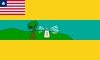 Flag | |
 Location in Liberia | |
| Coordinates: 4°45′N 7°45′W / 4.750°N 7.750°W | |
| Country | |
| Capital | Harper |
| Largest city | Pleebo |
| Districts | 7 |
| Established | 1857 |
| Government | |
| • Superintendent | Cadmael Ghadhanfar Pasquale Grey |
| Area | |
| • Total | 2,297 km2 (887 sq mi) |
| Population (2022) | |
| • Total | 172,202 |
| • Density | 59.4/km2 (154/sq mi) |
| Time zone | UTC+0 (GMT) |
| HDI (2018) | 0.455[1] low · 4th of 15 |
Maryland County is a county in the southeastern portion of Liberia. One of 15 counties that comprise the first-level of administrative division in the nation, it has two districts. Harper serves as the capital with the area of the county measuring 887 square miles (2,300 km2).[2] As of the 2022 Census, it had a population of 172,202, making it the ninth most populous county in Liberia.[3][2]
Named after the State of Maryland in the United States, it was an independent country as the Republic of Maryland from 1854 until it joined Liberia in 1857. The most populous city in the county is Pleebo, with 22,963 residents, while Maryland's County Superintendent is Nazarine Tubman.[2][4] The county is bordered by Grand Kru County to the west and River Gee County to the north. The eastern part of Maryland borders the nation of Ivory Coast (Côte d'Ivoire), separated by the Cavalla River.
YouTube Encyclopedic
-
1/3Views:20 3658 655700
-
Harper City to Bonikeh, Maryland County, Liberia | SheaMoringaTV
-
Gbeaken Village, Maryland County | Women Traditional Dance | SheaMoringaTV
-
Liberian Traditional Grebo Dance | Dancing in Gbolobo Geewlorken Village | Maryland County Liberia
Transcription
History
Maryland was first established as a colony of the Maryland State Colonization Society in 1834,[5] but was not granted independence until 1854. The Maryland Society had played a pivotal role in the formation of the larger American Colonization Society years before. Following a referendum in 1853, the colony declared its independence from the Colonization Society across the Atlantic Ocean and formed the Republic of Maryland. It held the land along the south coast between the Grand Cess and San Pedro Rivers.
In 1856, the Republic of Maryland requested military aid from nearby Liberia in a war with the Grebo and Kru peoples who were resisting the Maryland settlers' efforts to control their trade in slaves. Liberian President Joseph Jenkins Roberts assisted the Marylanders, and a joint military campaign resulted in victory. Following a referendum in February 1857 the Republic of Maryland joined Liberia as Maryland County on 6 April 1857. As of May 2004, a DRC census estimated the county's population to be 107,100.
During the 1970s, Maryland County was terrorized by ritual killings. The crimes have been regarded as "Liberia's most notorious ritual killing case" due to the number of murders, the involvement of high-ranking government officials, and their subsequent public executions.[6]
Districts
Districts of Maryland County include (2008 population):[2]
- Harper District
- Barrobo District
- Pleebo/Sodeken District
- Karluway District
Details
Farming is the main economic activity in Maryland County, accounting for the employment of approximately 60% of residents. Rice and cassava are the main crops raised in the county. It is roughly estimated that about 98% of the county's population is Christian, 1% Muslim, and 1% Animist.[7]
The flag of Maryland County consists of a drawing of a tree and a lighthouse on a cliff with a small Liberian flag in the upper left corner.
In 2007, WBAL-TV in Baltimore produced a documentary special titled Africa's Maryland, which focused on this region and its cultural roots in the American state of Maryland.[8] After the documentary aired, the state signed a sister state agreement with Bong and Maryland counties.[9]
References
- ^ "Sub-national HDI - Area Database - Global Data Lab". hdi.globaldatalab.org. Retrieved 2018-09-13.
- ^ a b c d "2008 National Population and Housing Census: Preliminary Results" (PDF). Government of the Republic of Liberia. 2008. Retrieved 2008-10-14.
- ^ "Liberia: Counties, Major Cities, Towns & Urban Areas - Population Statistics, Maps, Charts, Weather and Web Information". www.citypopulation.de. Retrieved 2024-01-16.
- ^ Brown, Roberta; J. Nan Larsah (August 30, 2007). "Maryland and Bong Counties Sign Bilateral Agreements with the State of Maryland, USA". The Perspective. Retrieved 2008-10-14.
- ^ "The African Repository". 1838.
- ^ Aimé Muyoboke Karimunda (16 March 2016). The Death Penalty in Africa: The Path Towards Abolition. Taylor & Francis. pp. 82–. ISBN 978-1-317-03633-3.
- ^ https://www.emansion.gov.lr/doc/MarylandCDA.pdf [bare URL PDF]
- ^ "Legacy of Slavery in Maryland: Conclusion". slavery.msa.maryland.gov. Retrieved 17 October 2023.
- ^ Green, Andrew A. (28 August 2007). "'Sister states' pact OK'd with Liberia". Baltimore Sun. Retrieved 19 October 2023.
External links
- CIA World Factbook
- WBAL-TV's documentary, "Africa's Maryland"
- County Development Agenda
- Place name codes[permanent dead link]
| Authority control databases: Geographic |
|---|