
Phrom Khiri
พรหมคีรี | |
|---|---|
 Phromlok Waterfall, part of Khao Luang National Park, Ban Ko, Phrom Khiri | |
 District location in Nakhon Si Thammarat province | |
| Coordinates: 8°31′18″N 99°49′30″E / 8.52167°N 99.82500°E | |
| Country | Thailand |
| Province | Nakhon Si Thammarat |
| Seat | Phrommalok |
| Area | |
| • Total | 321.50 km2 (124.13 sq mi) |
| Population (2012) | |
| • Total | 36,906 |
| • Density | 114.79/km2 (297.3/sq mi) |
| Time zone | UTC+7 (ICT) |
| Postal code | 80320 |
| Geocode | 8002 |
Phrom Khiri (Thai: พรหมคีรี, pronounced [pʰrōm kʰīː.rīː]) is a district (amphoe) of Nakhon Si Thammarat province, southern Thailand.
History
On 26 August 1974 the minor district (king amphoe) Phrom Khiri was formed with the three tambons Phrom Lok, Ban Ko, and In Khiri split from Mueang Nakhon Si Thammarat district.[1] On 13 July 1981 it was upgraded to a full district.[2]
Geography
Phrom Khiri is located 16 km (9.9 mi) from Nakhon Si Thammarat Airport, and taking approximately 20 minutes to reach.
The district is located in the midst of rubber plantations and surrounded by lush forests. There're small streets cutting through to allow access to the village.
Neighboring districts are (from the north clockwise): Nopphitam, Tha Sala, Mueang Nakhon Si Thammarat, Lan Saka, and Phipun.
Administration
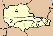
The district is divided into five sub-districts (tambons), which are further subdivided into 39 villages (mubans). There are two townships (thesaban tambons): Phrom Lok covers parts of tambons Phrom Lok and Ban Ko, and Thon Hong part of the same-named tambon. Each tambon has its non-municipal areas administered by a tambon administrative organization (TAO).
|
|
Motto
The Phrom Khiri district's motto is "The land of fruit, clean waterfalls, precious nature, a variety of folk wisdom, inherit the culture".
References
- ^ ประกาศกระทรวงมหาดไทย เรื่อง แบ่งท้องที่อำเภอเมืองนครศรีธรรมราช จังหวัดนครศรีธรรมราช ตั้งเป็นกิ่งอำเภอพรหมคีรี (PDF). Royal Gazette (in Thai). 91 (144 ก): 3285. August 27, 1974. Archived from the original (PDF) on June 12, 2012.
- ^ พระราชกฤษฎีกาตั้งอำเภอหนองใหญ่ อำเภอบ่อไร่ อำเภอพรหมคีรี อำเภอนาบอน อำเภอบางสะพานน้อย อำเภอนาดี อำเภอกงหรา อำเภอวังทรายพูน อำเภอธารโต อำเภอคำตากล้า อำเภอศรีนคร อำเภอด่านช้าง อำเภอพรเจริญ อำเภอวังสามหมอ และอำเภอลานสัก พ.ศ. ๒๕๒๔ (PDF). Royal Gazette (in Thai). 98 (115 ก Special): 7–10. July 13, 1981. Archived from the original (PDF) on September 30, 2007.
External links
This Nakhon Si Thammarat Province location article is a stub. You can help Wikipedia by expanding it. |