
Bang Khan
บางขัน | |
|---|---|
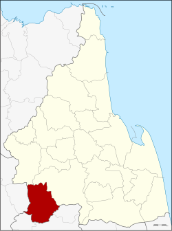 District location in Nakhon Si Thammarat province | |
| Coordinates: 8°1′36″N 99°28′24″E / 8.02667°N 99.47333°E | |
| Country | Thailand |
| Province | Nakhon Si Thammarat |
| Seat | Ban Lamnao |
| Area | |
| • Total | 601.7 km2 (232.3 sq mi) |
| Population (2005) | |
| • Total | 40,498 |
| • Density | 67.3/km2 (174/sq mi) |
| Time zone | UTC+7 (ICT) |
| Postal code | 80360 |
| Geocode | 8017 |
Bang Khan (Thai: บางขัน, pronounced [bāːŋ kʰǎn]) is a district (amphoe) of Nakhon Si Thammarat province, southern Thailand.
YouTube Encyclopedic
-
1/3Views:884573 013432
-
Bang Saphan Noi Morning Beach Walk - Prachuap Khiri Khan Thailand 2022
-
What Are Latitude & Longitude? | Locating Places On Earth | The Dr Binocs Show | Peekaboo Kidz
-
[4K] Big Street Food Market - Indy Night Street Food Market in Bang Yi Khan Bangkok
Transcription
Geography
Neighboring districts are (from the north clockwise): Thung Yai and Thung Song of Nakhon Si Thammarat; Ratsada, Huai Yot, and Wang Wiset of Trang province; and Lam Thap of Krabi province.
History
The district was created as a minor district (king amphoe) on 1 April 1984, when the three tambons Bang Khan, Ban Lamnao, and Wang Hin were split off from Thung Song district.[1] On 9 April 1992, the minor district was upgraded to a full district.[2]
Administration
The district is divided into four sub-districts (tambons), which are further subdivided into 60 villages (mubans). There are no municipal (thesaban) areas, and three tambon administrative organizations (TAO).
|

|
References
- ^ ประกาศกระทรวงมหาดไทย เรื่อง แบ่งท้องที่อำเภอทุ่งสง จังหวัดนครศรีธรรมราช ตั้งเป็นกิ่งอำเภอบางขัน (PDF). Royal Gazette (in Thai). 101 (57 ง): 1278. 1 May 1984. Archived from the original (PDF) on 12 June 2012.
- ^ พระราชกฤษฎีกาตั้งอำเภอสอยดาว อำเภอโพนสวรรค์ อำเภอบางขัน อำเภอหว้านใหญ่ อำเภอเมืองปาน อำเภอภูหลวง อำเภอโคกศรีสุพรรณ และอำเภอสำโรง พ.ศ. ๒๕๓๕ (PDF). Royal Gazette (in Thai). 109 (45 ก): 27–29. 9 April 1992. Archived from the original (PDF) on 14 February 2012.
External links
This Nakhon Si Thammarat Province location article is a stub. You can help Wikipedia by expanding it. |