
Parutyne
Парутине | |
|---|---|
 Coat of arms | |
 Parutyne 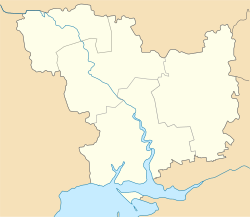 Parutyne | |
| Coordinates: 46°42′23″N 31°53′48″E / 46.70639°N 31.89667°E | |
| Country | |
| Region | Mykolaiv Oblast |
| Raion | Mykolaiv Raion |
| Administrative Classification | KOATUU: 4825182801 |
| Founded | 1789 |
| Area | |
| • Total | 2.17 km2 (0.84 sq mi) |
| Elevation | 24 m (79 ft) |
| Population | |
| • Total | 1,996 |
| • Density | 919.82/km2 (2,382.3/sq mi) |
| Time zone | UTC+2 (EET) |
| • Summer (DST) | UTC+3 (EEST) |
| Postal code | 57540 |
| Area code | +380 5154 |
 | |
Parutyne (Ukrainian: Парутине) is a village of Mykolaiv Raion, Mykolaiv Oblast, in Southern Ukraine. The village is a center of local rural community ("silrada").
On territory of the village are located ruins of the Ancient Greek polis Olbia.
The settlement was founded in 1789 at Parutyne balka (gulch) near location known "Sta Mohyl" (Hundreds burials) by former Nekrasov Cossacks–Lipovans who resettled here from Cioburciu (Chobruchi).[1]
Following the Siege of Ochakov during the 1787–1792 Russo-Turkish War, in 1792 over 12,000 desiatinas (~32.5 thousands of acres) of land with Parutyne at the right bank of Boh liman (Southern Bug estuary) near Ochakiv were given by Catherine the Great to "Malorossian" landowner and son of former Cossack Hetmanate official, Count Illia Bezborodko.[1]
After that Nekrassov Cossacks left Parutyne and returned to Dniester banks, while Bezborodko resettled the area with own serfs primarily from Chernigov Governorate (former Cossack Hetmanate).[1] The settlement was renamed as Ilyinske.[1] During the 1795 revision in Ilyinske lived 324 males.[1] At first the village belonged to Kherson county of Novorossiysk Governorate, and since 1827 to Odessa county of Kherson Governorate.[1] In 1858 Ilyinske is mentioned in historical sources as a town (miestechko) which accounted for over 100 households (dvory - courts) with 864 serfs.[1]
YouTube Encyclopedic
-
1/3Views:15 07518 9011 444
-
Причорномор'я. Україна з неба · Eкспедиція Ukraїner
-
Ольвія: найбільший античний поліс Причорномор'я · Ukraїner
-
Trypillia mega-sites from the 4th Millennium BCE in the Ukrainian Forest Steppe
Transcription
References
This article about a location in Mykolaiv Oblast is a stub. You can help Wikipedia by expanding it. |