
| Northeast Greenland National Park | |
|---|---|
 Franz Josef Fjord, glacier. The orange colour is caused by reflected sunlight. | |
 | |
| Location | |
| Coordinates | 76°N 30°W / 76°N 30°W |
| Area | 972,000 km2 (375,000 sq mi) |
| Established | 21 May 1974 |
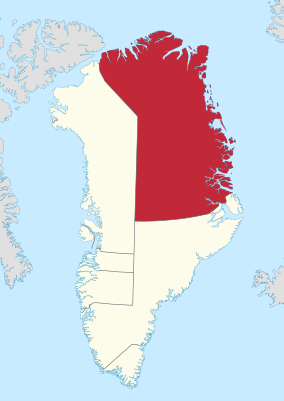
Northeast Greenland National Park (Greenlandic: Kalaallit Nunaanni nuna eqqissisimatitaq, Danish: Grønlands Nationalpark) is the world's largest national park and the 10th largest protected area (the only larger protected areas consist mostly of sea).[1] Established in 1974, the Northeast Greenland national park expanded to its present size in 1988. It protects 972,000 km2 (375,000 sq mi)[2] of the interior and northeastern coast of Greenland and is larger than the area of Tanzania, but smaller than that of Egypt. This means that the national park is bigger than 166 of the world's 195 countries. It was the first national park to be created in the Kingdom of Denmark and remains Greenland's only national park. It is the northernmost national park in the world and the second-largest by area of any second-level subdivision of any country in the world, trailing only the Qikiqtaaluk Region in Nunavut, Canada.
YouTube Encyclopedic
-
1/2Views:640433
-
Largest National Park In The World
-
The largest national park in the world! #shorts #greenland
Transcription
Geography
The park shares borders, largely laid out as straight lines, with the Sermersooq municipality in the south and with the Avannaata municipality in the west, partly along the 45° West meridian on the ice cap. The large interior of the park is part of the Greenland Ice Sheet, but there are also large ice-free areas along the coast and on Peary Land in the north. The park includes the King Frederick VIII Land and King Christian X Land geographical areas.
History
Originally established on 22 May 1974 from the northern, practically uninhabited part of the former Ittoqqortoormiit Municipality in Tunu (East Greenland), in 1988 the park was expanded by another 272,000 km2 (105,000 sq mi) to its present size, adding the northeastern part of the former county of Avannaa (North Greenland). In January 1977, it was designated an international biosphere reserve. The park is overseen by the Greenland Department of Environment and Nature. The historical research camps on the ice sheet—Eismitte and North Ice—fall within the boundaries of the present-day park.
Population

The park has no permanent human population, although 400 sites see occasional summertime use. In 1986, the population of the park was 40, living at Mestersvig. These 40 were involved in cleanup and closeout operations at mining exploration sites and soon left. Since then, censuses have recorded zero permanent human population. In 2008, only 31 people and about 110 dogs were present over winter in North East Greenland, distributed among the following stations (all on the coast, except Summit Camp):[3][4]
- Daneborg (12) headquarters of the Sirius Patrol, the park policing agency
- Danmarkshavn (8) civilian weather station
- Station Nord (5) military base
- Mestersvig (2) military outpost with 1,800 m (5,900 ft) gravel runway
- Zackenberg (0) summer-only research station
- Summit Camp (4) research station on the Greenland Ice Sheet
During summer, scientists add to these numbers. The research station Zackenberg Ecological Research Operations (ZERO) 74°28′11″N 20°34′15″W / 74.469725°N 20.570847°W can cater for over 20 scientists and station personnel.
Fauna


An estimated 5,000 to 15,000 musk oxen, as well as numerous polar bears and walrus, can be found near the coastal regions of the park. In 1993, this was estimated to be 40% of the world population of musk oxen. Other mammals include Arctic fox, stoat, collared lemming, Arctic hare and a small but important population of Greenland wolf. Other marine mammals include ringed seal, bearded seal, harp seal and hooded seal as well as narwhal and beluga whale.[5]
Species of birds which breed in the park include great northern diver, barnacle goose, pink-footed goose, common eider, king eider, gyrfalcon, snowy owl, sanderling, ptarmigan and raven.[5]
See also
References
- ^ "The National Park". Greenland.com. Retrieved 2013-06-18.
- ^ Statistics Greenland, Greenland in Figures, 2009
- ^ "The Sirius Sledge Patrol". Destination EastGreenland. Archived from the original on 2011-04-21. Retrieved 2008-10-03.
- ^ NOAA Research Archived 2008-09-16 at the Wayback Machine
- ^ a b "Kalaallit Nunaat high arctic tundra". Terrestrial Ecoregions. World Wildlife Fund. Retrieved 2008-10-03.
External links
- Webpage on visitgreenland.com
- Image gallery
- UN website on the park
- ZERO - Zackenberg Ecological Research Operations
- "Kalaallit Nunaat high arctic tundra". Terrestrial Ecoregions. World Wildlife Fund.
- Exploration History of Northeast Greenland
- Icebergs in Hekla Havn - slideshow
Places adjacent to Northeast Greenland National Park | ||||||||||||||||
|---|---|---|---|---|---|---|---|---|---|---|---|---|---|---|---|---|
| ||||||||||||||||
| |||||||
Administrative divisions of Greenland (since 2018) | ||
|---|---|---|
| Municipalities | ||
| Unincorporated Areas | ||
| |||||||
| History |  | ||||||
| Geography | |||||||
| Politics | |||||||
| Economy | |||||||
| Society |
| ||||||
| International | |
|---|---|
| National | |