
Monona, Iowa | |
|---|---|
 Monona water tower | |
| Motto: The Garden City. | |
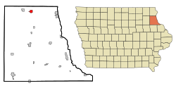 Location of Monona, Iowa | |
| Coordinates: 43°3′5″N 91°23′26″W / 43.05139°N 91.39056°W | |
| Country | |
| State | |
| County | Clayton |
| Area | |
| • Total | 1.36 sq mi (3.53 km2) |
| • Land | 1.36 sq mi (3.53 km2) |
| • Water | 0.00 sq mi (0.00 km2) |
| Elevation | 1,214 ft (370 m) |
| Population (2020) | |
| • Total | 1,471 |
| • Density | 1,080.03/sq mi (416.90/km2) |
| Time zone | UTC-6 (Central (CST)) |
| • Summer (DST) | UTC-5 (CDT) |
| ZIP code | 52159 |
| Area code | 563 |
| FIPS code | 19-53310 |
| GNIS feature ID | 0459174 |
| Website | City of Monona Website |
Monona is a city in Clayton County, Iowa, United States. The population was 1,471 at the time of the 2020 census.[2]
YouTube Encyclopedic
-
1/2Views:4262 052
-
Monona, Iowa | 2021
-
Entry to the Spook Cave by boat in Monona Iowa
Transcription
History
The name Monona is of American native origin.[3]
In 1916, Monona contained a public house, two stores, and several mechanic shops.[4]
Geography
Monona is located at 43°3′5″N 91°23′26″W / 43.05139°N 91.39056°W (43.051258, -91.390529).[5]
According to the United States Census Bureau, the city has a total area of 1.17 square miles (3.03 km2), all land.[6]
Demographics
| Year | Pop. | ±% |
|---|---|---|
| 1880 | 420 | — |
| 1890 | 460 | +9.5% |
| 1900 | 674 | +46.5% |
| 1910 | 792 | +17.5% |
| 1920 | 1,049 | +32.4% |
| 1930 | 1,163 | +10.9% |
| 1940 | 1,191 | +2.4% |
| 1950 | 1,346 | +13.0% |
| 1960 | 1,346 | +0.0% |
| 1970 | 1,395 | +3.6% |
| 1980 | 1,530 | +9.7% |
| 1990 | 1,520 | −0.7% |
| 2000 | 1,550 | +2.0% |
| 2010 | 1,549 | −0.1% |
| 2020 | 1,471 | −5.0% |
| Source:"U.S. Census website". United States Census Bureau. Retrieved March 29, 2020. and Iowa Data Center Source: | ||
2010 census
At the 2010 census there were 1,549 people, 675 households, and 440 families living in the city. The population density was 1,323.9 inhabitants per square mile (511.2/km2). There were 725 housing units at an average density of 619.7 per square mile (239.3/km2). The racial makeup of the city was 98.3% White, 0.5% African American, 0.1% Native American, 0.3% Asian, 0.3% from other races, and 0.6% from two or more races. Hispanic or Latino of any race were 1.0%.[8]
Of the 675 households, 29.5% had children under the age of 18 living with them, 52.1% were married couples living together, 8.7% had a female householder with no husband present, 4.3% had a male householder with no wife present, and 34.8% were non-families. 30.8% of households were one person and 16.6% were one person aged 65 or older. The average household size was 2.29 and the average family size was 2.83.
The median age was 42.4 years. 23.6% of residents were under the age of 18; 6.9% were between the ages of 18 and 24; 22.7% were from 25 to 44; 26.5% were from 45 to 64; and 20.2% were 65 or older. The gender makeup of the city was 48.5% male and 51.5% female.
2000 census
At the 2000 census there were 1,550 people, 659 households, and 432 families living in the city. The population density was 1,344.6 inhabitants per square mile (519.2/km2). There were 706 housing units at an average density of 612.4 per square mile (236.4/km2). The racial makeup of the city was 98.65% White, 0.06% African American, 0.58% Native American, 0.39% Asian, and 0.32% from two or more races. Hispanic or Latino of any race were 0.06%.[9]
Of the 659 households, 28.7% had children under the age of 18 living with them, 55.4% were married couples living together, 5.8% had a female householder with no husband present, and 34.4% were non-families. 30.3% of households were one person and 19.0% were one person aged 65 or older. The average household size was 2.35 and the average family size was 2.93.
Age spread: 24.1% under the age of 18, 6.5% from 18 to 24, 26.9% from 25 to 44, 19.2% from 45 to 64, and 23.4% 65 or older. The median age was 40 years. For every 100 females, there were 90.9 males. For every 100 females age 18 and over, there were 89.7 males.
The median household income was $35,000 and the median family income was $42,679. Males had a median income of $28,942 versus $19,954 for females. The per capita income for the city was $18,746. About 5.2% of families and 7.3% of the population were below the poverty line, including 6.2% of those under age 18 and 9.0% of those age 65 or over.
Education
It is within the MFL MarMac Community School District.[10] The district formed on July 1, 1994, with the merger of the Mar-Mac and M-F-L districts.[11]
Notable people
- Leighton Abel, Iowa state politician and businessman
- Alexander Gardner, photographer
- Raef LaFrentz, basketball player
References
- ^ "2020 U.S. Gazetteer Files". United States Census Bureau. Retrieved March 16, 2022.
- ^ a b "2020 Census State Redistricting Data". census.gov. United states Census Bureau. Retrieved August 12, 2021.
- ^ "Profile for Monona, Iowa". ePodunk. Retrieved February 22, 2014.
- ^ Price, Realto E. (1916). History of Clayton County, Iowa: From the Earliest Historical Times Down to the Present. Robert O. Law Company. pp. 86.
- ^ "US Gazetteer files: 2010, 2000, and 1990". United States Census Bureau. February 12, 2011. Retrieved April 23, 2011.
- ^ "US Gazetteer files 2010". United States Census Bureau. Archived from the original on January 25, 2012. Retrieved May 11, 2012.
- ^ "Census of Population and Housing". Census.gov. Retrieved June 4, 2015.
- ^ "U.S. Census website". United States Census Bureau. Retrieved May 11, 2012.
- ^ "U.S. Census website". United States Census Bureau. Retrieved January 31, 2008.
- ^ "MFL Mar Mac" (PDF). Iowa Department of Education. Retrieved March 27, 2020.
- ^ "REORGANIZATION & DISSOLUTION ACTIONS SINCE 1965-66" (PDF). Iowa Department of Education. Archived from the original (PDF) on February 9, 2019. Retrieved March 22, 2020.
External links
- City-Data Comprehensive Statistical Data and more about Monona
Municipalities and communities of Clayton County, Iowa, United States | ||
|---|---|---|
| Cities |  | |
| Townships | ||
| Unincorporated communities | ||
| Footnotes | ‡This populated place also has portions in an adjacent county or counties | |