
| Line 9 / Línea 9 | |||||||||||||||||||||||||||||||||||||||||||||||||||||||||||||||||||||||||||||||||||||||||||||||||||||||||||||||||||||||||||||||
|---|---|---|---|---|---|---|---|---|---|---|---|---|---|---|---|---|---|---|---|---|---|---|---|---|---|---|---|---|---|---|---|---|---|---|---|---|---|---|---|---|---|---|---|---|---|---|---|---|---|---|---|---|---|---|---|---|---|---|---|---|---|---|---|---|---|---|---|---|---|---|---|---|---|---|---|---|---|---|---|---|---|---|---|---|---|---|---|---|---|---|---|---|---|---|---|---|---|---|---|---|---|---|---|---|---|---|---|---|---|---|---|---|---|---|---|---|---|---|---|---|---|---|---|---|---|---|---|
 An MP-68 train at Pantitlán station | |||||||||||||||||||||||||||||||||||||||||||||||||||||||||||||||||||||||||||||||||||||||||||||||||||||||||||||||||||||||||||||||
| Overview | |||||||||||||||||||||||||||||||||||||||||||||||||||||||||||||||||||||||||||||||||||||||||||||||||||||||||||||||||||||||||||||||
| Locale | Mexico City | ||||||||||||||||||||||||||||||||||||||||||||||||||||||||||||||||||||||||||||||||||||||||||||||||||||||||||||||||||||||||||||||
| Termini | |||||||||||||||||||||||||||||||||||||||||||||||||||||||||||||||||||||||||||||||||||||||||||||||||||||||||||||||||||||||||||||||
| Connecting lines |
| ||||||||||||||||||||||||||||||||||||||||||||||||||||||||||||||||||||||||||||||||||||||||||||||||||||||||||||||||||||||||||||||
| Stations | 12 | ||||||||||||||||||||||||||||||||||||||||||||||||||||||||||||||||||||||||||||||||||||||||||||||||||||||||||||||||||||||||||||||
| Service | |||||||||||||||||||||||||||||||||||||||||||||||||||||||||||||||||||||||||||||||||||||||||||||||||||||||||||||||||||||||||||||||
| Type | Rapid transit | ||||||||||||||||||||||||||||||||||||||||||||||||||||||||||||||||||||||||||||||||||||||||||||||||||||||||||||||||||||||||||||||
| System | Mexico City Metro | ||||||||||||||||||||||||||||||||||||||||||||||||||||||||||||||||||||||||||||||||||||||||||||||||||||||||||||||||||||||||||||||
| Operator(s) | Sistema de Transporte Colectivo (STC) | ||||||||||||||||||||||||||||||||||||||||||||||||||||||||||||||||||||||||||||||||||||||||||||||||||||||||||||||||||||||||||||||
| Rolling stock | NM-79, NC-82, NM-83, NE-92 | ||||||||||||||||||||||||||||||||||||||||||||||||||||||||||||||||||||||||||||||||||||||||||||||||||||||||||||||||||||||||||||||
| Ridership | 311,686 passengers per day (2019)[1] | ||||||||||||||||||||||||||||||||||||||||||||||||||||||||||||||||||||||||||||||||||||||||||||||||||||||||||||||||||||||||||||||
| History | |||||||||||||||||||||||||||||||||||||||||||||||||||||||||||||||||||||||||||||||||||||||||||||||||||||||||||||||||||||||||||||||
| Opened | 26 August 1987 | ||||||||||||||||||||||||||||||||||||||||||||||||||||||||||||||||||||||||||||||||||||||||||||||||||||||||||||||||||||||||||||||
| Technical | |||||||||||||||||||||||||||||||||||||||||||||||||||||||||||||||||||||||||||||||||||||||||||||||||||||||||||||||||||||||||||||||
| Line length | 13.033 km (8 mi) | ||||||||||||||||||||||||||||||||||||||||||||||||||||||||||||||||||||||||||||||||||||||||||||||||||||||||||||||||||||||||||||||
| Track length | 15.375 km (10 mi) | ||||||||||||||||||||||||||||||||||||||||||||||||||||||||||||||||||||||||||||||||||||||||||||||||||||||||||||||||||||||||||||||
| Track gauge | 1,435 mm (4 ft 8+1⁄2 in) standard gauge with roll ways along track | ||||||||||||||||||||||||||||||||||||||||||||||||||||||||||||||||||||||||||||||||||||||||||||||||||||||||||||||||||||||||||||||
| Electrification | Guide bars | ||||||||||||||||||||||||||||||||||||||||||||||||||||||||||||||||||||||||||||||||||||||||||||||||||||||||||||||||||||||||||||||
| Operating speed | 36 km/h (22 mph) | ||||||||||||||||||||||||||||||||||||||||||||||||||||||||||||||||||||||||||||||||||||||||||||||||||||||||||||||||||||||||||||||
| |||||||||||||||||||||||||||||||||||||||||||||||||||||||||||||||||||||||||||||||||||||||||||||||||||||||||||||||||||||||||||||||
Mexico City Metro Line 9 is one of the 12 metro lines built in Mexico City, Mexico.
YouTube Encyclopedic
-
1/2Views:365334
-
World Metro Systems: Mexico City Metro
-
The CHEAPEST SAFEST Way to Get Around Mexico City in 2023 | Mexico City Metro Ultimate Guide
Transcription
General information
Line 9 was the 8th metro line to be built in the network, built between 1985 and 1988. (Line 8 started operations until 1994). It is identified by the color dark brown, and runs from East to West in an almost straight fashion. It was built in order to support Line 1, providing a redistribution alternative for east–west commuters.[2] It starts in the multi-line transfer station Pantitlán and ends at the western neighborhood of Tacubaya, both stations also served by Line 1. As a comparison, the section between Pantitlán and Tacubaya is served by 19 stations in Line 1, whereas Line 9 has only 12, which would translate in a faster alternative.
Line 9 is built in its easternmost section above the Rio Churubusco and Rio de la Piedad Avenues. Then it reaches an underground route near the Magdalena Mixiuhca Complex and it continues under the Eje 3 Sur until reaching the Tacubaya zone, where the last station is built under Jalisco avenue. As part of the first expansion plans in the 1980s the line is expected to turn west after Jalisco Avenue to reach Observatorio Station.[3]
History
Due to the subsidence of the city, there have been problems with the elevated portion of the line (which runs from Pantitlán to Velódromo stations). Following the collapse of a Mexico City Metro overpass in 2021, these concerns increased when commuters reported plainly visible deformations in the bridge connecting the Pantitlán and Puebla stations.[4] As of February 2023, authorities had reinforced Line 9's overpass with metallic supports.[5] The city government informed that a small section between Pantitlán and Puebla stations will be rebuilt between November 2023 and April 2024 as a result of the problem's persistence.[6]
Chronology
- 26 August 1987: from Pantitlán to Centro Médico.
- 29 August 1988: from Centro Médico to Tacubaya.
Rolling stock
Line 8 has had different types of rolling stock throughout the years.
- Alstom MP-68: 1987–1996; 1996–2008
- Concarril NM-73: 1987–2008
- Concarril NM-79: 2008–present
- Alstom MP-82: 1987–1994
- Bombardier NC-82: 2008–present
- Concarril NM-83: 2013–present
- CAF NE-92 2018–present
As of 2020, out of the 390 trains in the Mexico City Metro network, 29 are in service in Line 9.[7]
Station list
| Denotes a partially accessible station | |
| Denotes a fully accessible station | |
| Denotes a metro transfer | |
| Denotes a connection with the Centro de transferencia modal (CETRAM) system | |
| Denotes a connection with the Ecobici system | |
| Denotes a connection with the Metrobús system | |
| Denotes a connection with the Mexibús system | |
| Denotes a connection with the public bus system | |
| Denotes a connection with the Red de Transporte de Pasajeros (RTP) system | |
| Denotes a connection with the Trolleybus system |
The stations from west to east:

| No. | Station | Date opened | Level | Distance (km) | Connection | Pictogram | Location | |
|---|---|---|---|---|---|---|---|---|
| Between stations |
Total | Description | ||||||
| 01 | Pantitlán |
August 26, 1987 | Elevated, overground access | - | 0.0 |
|
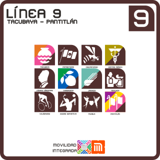
Pantitlán is a Nahuatl word that means between flags. In Aztec times, this place was part of Lake Texcoco. There was a culvert where the whirlpools came with such force that the canoes were carried away, so they fenced the place by putting up two posts, and as a warning to the navigators, the flags. The icon of the station represents two flags in reference to the navigation notices that the Aztecs placed in Lake Texcoco. | Iztacalco / Venustiano Carranza |
| 02 | Puebla |
1.5 | 1.5 |
|
It is located in the Puebla district of the Iztacalco delegation of Mexico City; both the area it is located in and the station are named for the nearby city of Puebla. The station logo represents some angels, as the city is commonly called The City of Angels. | |||
| 03 | Ciudad Deportiva |
0.9 | 2.4 |
|
It is named for the nearby the Magdalena Mixhuca Sports City. The logo for the station represents a player engaged in a Mesoamerican ballgame (a similar logo is used for Metro Deportivo 18 de Marzo on lines 3 and 6). | |||
| 04 | Velódromo |
1.3 | 3.7 |
|
It is named after the nearby Agustín Melgar Olympic Velodrome, or bicycle-racing venue, built for the 1968 Summer Olympics that were held in Mexico City. The logo for the station shows the silhouette of a bicycle racer. | Venustiano Carranza | ||
| 05 | Mixiuhca | Underground, trench | 1.0 | 4.7 |
|
The station's icon is a silhouette of a woman holding a newborn baby. In the Nahuatl language mixiuhca means "place of births". | ||
| 06 | Jamaica |
0.9 | 5.6 |
|
The station logo depicts an ear of corn. Its name refers to the nearby wholesale market of Jamaica. | |||
| 07 | Chabacano |
1.2 | 6.8 |
|
The station's pictogram depicts an apricot and it was named after a previously existing street that had multiple apricot trees. | Cuauhtémoc | ||
| 08 | Lázaro Cárdenas | 1.1 | 7.9 |
|
It receives its name from the Eje Central Lázaro Cárdenas which crosses the Eje 3 sur at that height. Lázaro Cárdenas del Río was president of Mexico from 1934 to 1940. He is famous for being the one who expropriated the foreign companies that extracted Mexican oil (Expropriation Petrolera). He was also the president who helped Spanish refugees during the Spanish Civil War. The station logo shows a portrait in profile of him. | |||
| 09 | Centro Médico |
1.2 | 9.1 |
|
The station logo represents the caduceus, a variant of the Rod of Aesculapius, the Greek god of medicine. Its name refers to the Centro Médico Nacional Siglo XXI general hospital, located above the metro station. | |||
| 10 | Chilpancingo |
August 29, 1988 | 1.3 | 10.5 |
|
The station is named after the nearby Avenida Chilpancingo, which in turn is named after the city of Chilpancingo de los Bravo, the capital of the state of Guerrero. The station logo is the silhouette of a wasp since Chilpancingo means the place of the wasps in Nahuatl. | ||
| 11 | Patriotismo |
1.1 | 11.6 |
|
The station is named after Avenida Patriotismo which divides the Cuauhtémoc and Miguel Hidalgo boroughs. "Patriotismo" literally means patriotism, thus, the station logo depicts a Mexican flag. | Cuauhtémoc / Miguel Hidalgo | ||
| 12 | Tacubaya |
1.3 | 12.8 |
|
The station takes its name from the neighborhood it is located in: Tacubaya. The origin of this zone of the city can be traced back to an Aztec settlement, which back then was at the edge of Lake Texcoco. The name Tacubaya is a Spanish barbarism that derived from the Nahuatl Atlacuihuayan, that means "where water joins". Therefore, the station pictogram represents a water bowl, that also resembles the glyph of the Aztec settlement of Tacubaya found at the Codex Mendoza. | Miguel Hidalgo | ||
Proposed extension
Being Tacubaya a provisional terminal, Line 9 had an original project for being expanded to the west to reach Observatorio station as Line 1 did. After the announcement for the Toluca–Mexico City commuter rail, an expansion towards Observatorio station was announced in 2014.[15] As of 2021, the project is still under planification.
| No. | Station | Date opened | Situation | Distance (km) | Transfers | Location | |
|---|---|---|---|---|---|---|---|
| Between stations |
Total | ||||||
| 13 | Observatorio |
To be determined | Underground | 1.5 | 14.3 |
(under construction) |
Miguel Hidalgo |
Ridership
The following table shows each of Line 9 stations total and average daily ridership during 2019.[1]
| † | Transfer station |
| †‡ | Transfer station and terminal |
| Rank | Station | Total ridership | Average daily |
|---|---|---|---|
| 1 | Pantitlán†‡ | 32,839,328 | 89,971 |
| 2 | Tacubaya†‡ | 16,335,719 | 44,755 |
| 3 | Chilpancingo | 15,212,533 | 41,678 |
| 4 | Puebla | 12,185,200 | 33,384 |
| 5 | Mixiuhca | 6,694,736 | 18,342 |
| 6 | Patriotismo | 6,628,532 | 18,160 |
| 7 | Centro Médico† | 5,143,782 | 14,093 |
| 8 | Jamaica† | 4,561,989 | 12,499 |
| 9 | Lázaro Cárdenas | 4,363,376 | 11,954 |
| 10 | Chabacano† | 3,912,641 | 10,720 |
| 11 | Velódromo | 3,288,845 | 9,011 |
| 12 | Ciudad Deportiva | 2,598,847 | 7,120 |
| Total | 113,765,528 | 311,686 | |
Tourism
Line 9 passes near several places of interest:
- Magdalena Mixhuca Sports City, Olympic Park used for the 1968 Summer Olympics
- Palacio de los Deportes, indoor sports arena and concert venue.
- Autódromo Hermanos Rodríguez, motorsport race track venue of the Formula One Mexican Grand Prix.
- Foro Sol, sports and concert venue.
See also
Notes
- ^ The following list was adapted from different websites and official maps.
- Metro (
 ) connections obtained from the official Mexico City Metro system map.[8]
 - Accessibility obtained from the Mexico City Metro system map. In some cases, the map omits the accessibility icon as the station(s) are actually partially accessible. However, the respective websites of each station on the official site indicate the respective accessibility methods. Stations with the symbol
 ‡ are fully accessible; stations with the symbol
  † are partially accessible.[8]
 - Centro de transferencia modal (CETRAM;
 ) obtained from the official website of the Órgano Regulador de Transporte.[9]
 - Ecobici (
 ) obtained from their official website.[10]
 - Metrobús (
 ) obtained from the Mexico City Metrobús system map.[11]
 - Mexibús (
 ) obtained from the official Mexico City Metro system map.[8]
 - Public buses network (peseros) (
 ) obtained from the official website of the Órgano Regulador de Transporte.[12]
 - Red de Transporte de Pasajeros (
 ) obtained from their official website.[13]
 - Trolleybuses (
 ) obtained from their official website.[14]
- Metro (
References
- ^ a b "Afluencia de estación por línea 2019" (in Spanish). Metro CDMX. Retrieved 26 April 2020.
- ^ Treinta Años de Hacer el Metro, Ciudad de México. Grupo ICA. 1997. p. 277.
- ^ Treinta Años de Hacer el Metro, Ciudad de México. Grupo ICA. 1997.
- ^ Hernández, Eduardo (4 May 2021). "Se revisarán denuncias por cuarteaduras en Metro Oceanía y Pantitlán: Sheinbaum" [Complaints about cracks in Oceania and Pantitlan stations will be reviewed: Sheinbaum]. El Universal (in Spanish). Archived from the original on 5 May 2021. Retrieved 29 May 2021.
- ^ Díaz, Omar (13 February 2022). "After complaints, Pantitlán Line 9 metro station is reinforced: PICTURES". El Universal (in Spanish). Retrieved 7 March 2023.
- ^ Sánchez Aguilar, Julio César; Grifaldo, Iván (14 September 2023). "Cerrarán 3 estaciones de la Línea 9 del Metro CDMX por obras" [3 Line 9 stations will be closed for repairments]. Uno TV (in Spanish). Retrieved 14 September 2023.
- ^ "Parque vehicular" (in Spanish). Metro CDMX. Retrieved 26 April 2020.
- ^ a b c "Mi Mapa Metro 22032021" [My Metro Map 22032021] (PDF) (in Spanish). Sistema Transporte Colectivo Metro. 22 March 2021. Retrieved 30 October 2021.
- ^ "Centros de Transferencia Modal (CETRAM)" [Modal Transfer Centers] (in Spanish). Órgano Regulador de Transporte. Retrieved 30 October 2021.
- ^ "Mapa de disponibilidad" [Disponibility map] (in Spanish). Ecobici. Retrieved 30 October 2021.
- ^ "Mapa del sistema" [System map] (in Spanish). Mexico City Metrobús. Retrieved 30 October 2021.
- ^ "Red de corredores" [Route network] (in Spanish). Retrieved 30 October 2021.
- ^ "Red de Rutas" [Routes network] (in Spanish). Red de Transporte de Pasajeros. Retrieved 30 October 2021.
- ^ "Servicios" [Services] (in Spanish). Servicio de Transportes Eléctricos. Retrieved 30 October 2021.
- ^ "Anuncia Mancera ampliación de Línea 9 del Metro". www.milenio.com.
| Others | |
|---|---|
| |
| Former | |