
| Mickleton | |
|---|---|
 View over Mickleton | |
 Mickleton Location within Gloucestershire | |
| Population | 1,677 (2011 Census) |
| OS grid reference | SP161438 |
| Civil parish |
|
| District | |
| Shire county | |
| Region | |
| Country | England |
| Sovereign state | United Kingdom |
| Post town | CHIPPING CAMPDEN |
| Postcode district | GL55 |
| Dialling code | 01386, 01789 |
| Police | Gloucestershire |
| Fire | Gloucestershire |
| Ambulance | South Western |
| UK Parliament | |
| Website | Mickleton Parish Council |
Mickleton is a village and civil parish in the Cotswold District of Gloucestershire, England. The village is the northernmost settlement in Gloucestershire,[1] lying close to the borders with Worcestershire and Warwickshire, 3 miles (4.8 km) north of Chipping Campden, 8 miles (13 km) east of Evesham and 8 miles (13 km) south of Stratford-upon-Avon. The population of the parish was 1,677 at the 2011 Census.[2]
YouTube Encyclopedic
-
1/1Views:876
-
The Pudding Club
Transcription
Location
The village lies at the western edge of the Cotswold escarpment in the Vale of Evesham.
Attractions
Mickleton is noted for its market gardening and vegetable growing[3] Young plants, seed plugs, apples, cauliflowers and asparagus, or gras, are grown locally. Meon Hill, the scene of the so-called 'witchcraft' murder of Charles Walton in 1945, lies to the north of the village. Meon Hill is said to have inspired Tolkien's 'Weathertop' from The Lord of the Rings[4] According to legend, Meon Hill was formed by the Devil. He intended to throw a clod of earth at Evesham Abbey but missed, and the earth formed the hill.[5]
Mickleton has two old pubs, King's Arms and Butcher's Arms, and a hotel, Three Ways House Hotel. Sited on a green in front of the hotel is a memorial fountain by the Victorian architect William Burges.[6]
The Church of St Lawrence is an Anglican parish church. It contains a memorial to Utrecia Smith, the daughter of a curate of Mickleton whose father was also a schoolmaster. Utrecia had been the fiancée of the writer Richard Graves (who broke off their engagement); she died in 1744 aged 30.[7] At the heart of village activities is King George's Hall, located at the center of the village and home to the many clubs and societies that thrive in the village.
The Heart of England Way runs through the village. The village has many B&Bs that have been set up privately in people's own homes Local market towns and villages include Broadway, Chipping Campden, Stratford-upon-Avon, Moreton-in-Marsh and Evesham.
Both Hidcote Manor Garden and Kiftsgate Court Gardens are located nearby.
-
 St Lawrence's Church
 -
 A typical house
 -
 Three Ways House Hotel
 -
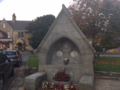 Memorial foundation by William Burges

Notable residents
- Sir Anthony Keck (1630–1695), Commissioner of the Great Seal, was born in Mickleton.
References
- ^ "Our Village". The Mickleton Society. Retrieved 30 October 2023.
- ^ "Parish population 2011". Retrieved 22 March 2015.
- ^ "Guide to Mickleton, Gloucestershire". Country Life. Retrieved 27 October 2019.
- ^ "10 beautiful north Cotswold villages you need to visit". Cotswold Life. Retrieved 27 October 2019.
- ^ Ash, Russell (1973). Folklore, Myths and Legends of Britain. Reader's Digest Association Limited. p. 325. ISBN 9780340165973.
- ^ Verey, David; Brooks, Alan (2000). Gloucestershire 1: The Cotswolds. The Buildings of England. Penguin. p. 477. ISBN 0140710981.
- ^ Evans, Herbert A. (1927) Highways and Byways in Oxford and the Cotswolds. London: Macmillan; p. 217
External links
- King George's Hall Mickleton
- Photos of Mickleton and surrounding area on geograph.org.uk
- Mickleton village
- Hidcote Bartrim & Hidcote Boyce are a mile away