
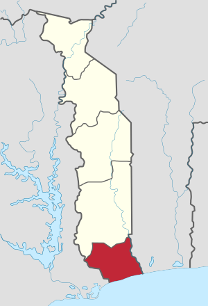

Maritime Region (French: Région maritime) is the southernmost of Togo's five regions, with the country's only shoreline on the Bight of Benin. Tsévié serves as the regional capital. It is the smallest region in terms of area, but it has the largest population, with 3.5 million people.[2]
Other major cities in the Maritime region include Lomé, the Capital of Togo, and Aného.
Maritime is located south of Plateaux Region. In the west, it borders the Volta Region of Ghana, and in the east it borders two departments of Benin: Kouffo farther north, and Mono farther south.
YouTube Encyclopedic
-
1/3Views:1 6461 17863 671
-
Togo Tourisme région maritime.wmv
-
Togo documentary Water situation in Togo (Maritime region, Noepe)
-
Discover TOGO. Economy, People. 10 Best Places To Visit In Togo. Visit Lome Togo.
Transcription
Prefectures

Maritime is divided into the prefectures of Avé, Bas-Mono, Golfe, Lacs, Vo, Yoto, and Zio.[3]
References
- ^ "Sub-national HDI - Area Database - Global Data Lab". hdi.globaldatalab.org. Retrieved 2018-09-13.
- ^ "Togo: Regions, Cities, Urban Localities & Agglomeration - Population Statistics, Maps, Charts, Weather and Web Information". www.citypopulation.de. Retrieved 2024-01-16.
- ^ "Annuaire Statistique du Togo (2010-2013)" (in French). October 2019. Retrieved 2021-08-06.
6°30′N 1°18′E / 6.500°N 1.300°E
| Authority control databases: Geographic |
|---|
This Togo location article is a stub. You can help Wikipedia by expanding it. |