
Manukau Ward | |
|---|---|
 | |
| Country | New Zealand |
| Island | North Island |
| Region | Auckland Region |
| Area | |
| • Land | 89.62 km2 (34.60 sq mi) |
| Population (June 2023)[2] | |
| • Total | 185,900 |
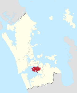
Manukau Ward is an Auckland Council ward that elects two councillors and covers the Māngere-Ōtāhuhu and Ōtara-Papatoetoe Local Boards. The two councillors are currently Alf Filipaina and Lotu Fuli.
Demographics
Manukau ward covers 89.62 km2 (34.60 sq mi)[1] and had an estimated population of 185,900 as of June 2023, with a population density of 2,074 people per km2.
| Year | Pop. | ±% p.a. |
|---|---|---|
| 2006 | 140,475 | — |
| 2013 | 146,619 | +0.61% |
| 2018 | 163,572 | +2.21% |
| Source: [3] | ||
Manukau ward had a population of 163,572 at the 2018 New Zealand census, an increase of 16,953 people (11.6%) since the 2013 census, and an increase of 23,097 people (16.4%) since the 2006 census. There were 38,295 households, comprising 81,888 males and 81,684 females, giving a sex ratio of 1.0 males per female. The median age was 29.1 years (compared with 37.4 years nationally), with 41,313 people (25.3%) aged under 15 years, 43,014 (26.3%) aged 15 to 29, 65,655 (40.1%) aged 30 to 64, and 13,596 (8.3%) aged 65 or older.
Ethnicities were 17.8% European/Pākehā, 16.0% Māori, 52.4% Pacific peoples, 27.4% Asian, and 1.5% other ethnicities. People may identify with more than one ethnicity.
The percentage of people born overseas was 42.8, compared with 27.1% nationally.
Although some people chose not to answer the census's question about religious affiliation, 18.5% had no religion, 54.3% were Christian, 1.8% had Māori religious beliefs, 9.0% were Hindu, 4.9% were Muslim, 1.6% were Buddhist and 4.8% had other religions.
Of those at least 15 years old, 15,849 (13.0%) people had a bachelor's or higher degree, and 25,782 (21.1%) people had no formal qualifications. The median income was $25,300, compared with $31,800 nationally. 9,321 people (7.6%) earned over $70,000 compared to 17.2% nationally. The employment status of those at least 15 was that 60,633 (49.6%) people were employed full-time, 13,902 (11.4%) were part-time, and 7,362 (6.0%) were unemployed.[3]
Councillors
| Manukau Ward councillors of Auckland | |
|---|---|
| Term length | Three years |
| Inaugural holder | Alf Filipaina Arthur Anae |
| Formation | 1 November 2010 |
| Website | www.aucklandcouncil.govt.nz |
| Election | Councillors elected | Affiliation | Votes | Notes | |
|---|---|---|---|---|---|
| 2010 | 1 | Alf Filipaina | Labour | 15235 | |
| 2 | Arthur Anae | Independent | 13260 | ||
| 2013 | 1 | Alf Filipaina | Labour | 17441 | |
| 2 | Arthur Anae | Independent | 12961 | ||
| 2016[4] | 1 | Alf Filipaina | Labour | 17327[5] | |
| 2 | Fa'anana Efeso Collins | Labour | 16500[5] | ||
| 2019 | 1 | Fa'anana Efeso Collins | Labour | 19053[6] | Stood down at 2022 Elections to run for Mayor |
| 2 | Alf Filipaina | Labour | 18814[6] | ||
| 2022 | 1 | Alf Filipaina | Labour | 16,734[7] | |
| 2 | Lotu Fuli | Labour | 14,935[7] | Won seat formerly held by Efeso Collins |
Election Results
Election Results for the Manukau Ward:
2022 Election Results
| Name | Affiliation | Votes | |
|---|---|---|---|
| 1 | Alf Filipaina | Labour | 16734 |
| 2 | Lotu Fuli | Labour | 14935 |
| Malcolm Turner | Communities and Residents | 8612 | |
| Hine Afeaki | Outdoors & Freedom | 5699 | |
| Blank | 1345 | ||
| Informal | 27 | ||
References
- ^ a b "ArcGIS Web Application". statsnz.maps.arcgis.com. Retrieved 24 February 2022.
- ^ "Subnational population estimates (RC, SA2), by age and sex, at 30 June 1996-2023 (2023 boundaries)". Statistics New Zealand. Retrieved 25 October 2023. (regional councils); "Subnational population estimates (TA, SA2), by age and sex, at 30 June 1996-2023 (2023 boundaries)". Statistics New Zealand. Retrieved 25 October 2023. (territorial authorities); "Subnational population estimates (urban rural), by age and sex, at 30 June 1996-2023 (2023 boundaries)". Statistics New Zealand. Retrieved 25 October 2023. (urban areas)
- ^ a b "Statistical area 1 dataset for 2018 Census". Statistics New Zealand. March 2020. Manukau Ward (07611).
- ^ "Local body election nominations close". Radio New Zealand. 2016-08-12. Retrieved 6 December 2017.
- ^ a b "Ward councillors – Manukau Ward confirmed" (PDF). Auckland Council. 2016. Retrieved 6 December 2017.
- ^ a b "Local board members" (PDF). Auckland Council. 18 October 2019. Retrieved 21 October 2019.
- ^ a b c "Local Elections 2022 - Official Results" (PDF). Auckland Council. 15 October 2022. Archived (PDF) from the original on 17 October 2022. Retrieved 17 October 2022.