| Lulonga River | |
|---|---|
 The Lulonga River at the port of Basankusu | |
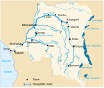
 The rivers of the central Democratic Republic of Congo, with the Lulonga and its tributaries (top left) | |
| Location | |
| Country | Democratic Republic of the Congo |
| Physical characteristics | |
| Mouth | |
• location | Congo River |
| Length | 200 km (120 mi) |
| Basin size | 76,950 km2 (29,710 sq mi) |
| Discharge | |
| • location | Confluence of Congo (near mouth) |
| • average | 2,040 m3/s (72,000 cu ft/s)[1] |
| Basin features | |
| Tributaries | |
| • left | Maringa |
| • right | Lopori |
The Lulonga (Swahili: Mto Lulonga, French: Rivière Lulonga) is a river in the Equateur province of Democratic Republic of the Congo. It is about 200 km long from its beginning at the town of Basankusu. The Lopori and the Maringa join to form the Lulonga there. The Lulonga River flows into the Congo River at the village of Lulonga.[2]
YouTube Encyclopedic
-
1/2Views:1 488358
-
Congo Kinshasa: Mbandaka to Basankusu by river
-
Top 10 Longest Rivers in the World | Longest Rivers in the World | World Longest Rivers
Transcription
References
- ^ Thibault, Lambert; Steven, Bouillon; François, Darchambeau; Philippe, Massicotte; Alberto, V. Borges. "Shift in the chemical composition of dissolved organic matter in the Congo River network" (PDF). Archived (PDF) from the original on 2023-05-29. Retrieved 2023-05-29.
- ^ Jef Dupain; Janet Nackoney; Jean-Paul Kibambe; Didier Bokelo & David Williams. "Maringa-Lopori-Wamba Landscape" (PDF). L'Observatoire des Forêts d'Afrique Centrale. Archived from the original (PDF) on 2016-03-03. Retrieved 2011-10-14.
0°38′40″N 18°22′58″E / 0.644489°N 18.3827877°E

