
Township of Lincoln | |
|---|---|
 Location of Lincoln Township in Washington County | |
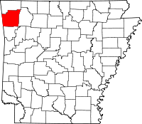 Location of Washington County in Arkansas | |
| Coordinates: 35°56′58″N 94°25′5″W / 35.94944°N 94.41806°W | |
| Country | |
| State | |
| County | Washington |
| Area | |
| • Total | 1.8 sq mi (5 km2) |
| • Land | 1.8 sq mi (5 km2) |
| • Water | 0.0 sq mi (0 km2) 0% |
| Elevation | 1,453 ft (443 m) |
| Population (2000) | |
| • Total | 1,752 |
| • Density | 983/sq mi (380/km2) |
| Time zone | UTC-6 (CST) |
| • Summer (DST) | UTC-5 (CDT) |
| Area code | 479 |
| GNIS feature ID | 2406956[1] |
Lincoln Township is one of thirty-seven townships in Washington County, Arkansas, USA.[2] As of the 2000 census, its total population was 1,752.
YouTube Encyclopedic
-
1/3Views:4212 3762 032
-
Baxter County Assessor - Elaine Quick
-
Northwest Indiana: 49 to the End
-
Shaping America's Border and Creating the Modern U.S. Military (1998)
Transcription
Geography
According to the United States Census Bureau, Lincoln Township covers an area of 1.8 square miles (4.7 km2); all land.[2] Lincoln Township is almost entirely engulfed by Starr Hill Township, with a very brief portion adjacent to Cane Hill Township.
Cities, towns, villages
Cemeteries
The township contains Bean Cemetery, one of the National Register of Historic Places listings in Washington County, Arkansas.
Major routes
References
- ^ a b U.S. Geological Survey Geographic Names Information System: Lincoln Township, Washington County, Arkansas
- ^ a b "Township of Lincoln, Washington County, Arkansas". U.S. Census Bureau. Retrieved August 29, 2011.
External links
Places adjacent to Lincoln Township, Washington County, Arkansas | ||||||||||||||||
|---|---|---|---|---|---|---|---|---|---|---|---|---|---|---|---|---|
| ||||||||||||||||

This Arkansas state location article is a stub. You can help Wikipedia by expanding it. |