
Lawton metropolitan area | |
|---|---|
| Lawton Metropolitan Statistical Area | |
 | |
| Coordinates: 34°39′45″N 98°28′35″W / 34.6625°N 98.4764°W | |
| Country | United States |
| State(s) | Oklahoma |
| Largest city | Lawton, Oklahoma |
| Other cities | - Cache - Elgin |
| Area | |
| • Total | 1,069.3 sq mi (2,769 km2) |
| Highest elevation | 2,476 ft (754 m) |
| Lowest elevation | 1,000 ft (304 m) |
| Population | |
| • Total | 130,291 (2,010 Census) |
| • Rank | 324th in the U.S. |
| • Density | 116.1/sq mi (44.8/km2) |
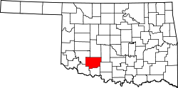
The Lawton Metropolitan Statistical Area, as defined by the United States Census Bureau, is an area consisting of two counties – Comanche and Cotton – in Oklahoma, anchored by the city of Lawton. As of the 2010 census, the MSA had a population of 130,291.[1][2]
YouTube Encyclopedic
-
1/3Views:27 8733571 816
-
Drive through Lawton city in Oklahoma
-
Driving on the Road, Lawton City Hood (Part 1), OK, U.S. (106)
-
Lawton Fort Sill - Best City - Oklahoma 2009
Transcription
Counties
Communities
Cities
Towns
- Ahpeatone
- Chattanooga (partial)
- Cookietown
- Devol
- Emerson Center
- Faxon
- Fivemile
- Fletcher
- Geronimo
- Hooper
- Hulen
- Indiahoma
- Medicine Park
- Randlett
- Sterling
- Taylor
- Temple
See also
References
- ^ "Table 1. Annual Estimates of the Population of Metropolitan and Micropolitan Statistical Areas: April 1, 2010 to July 1, 2012". 2012 Population Estimates. United States Census Bureau, Population Division. March 2013. Archived from the original (CSV) on April 1, 2013. Retrieved March 17, 2013.
- ^ "Oklahoma - Corebased Statistical Areas (CBSAs) and Counties" (PDF). United States Census Bureau.
34°39′45″N 98°28′35″W / 34.66250°N 98.47639°W