
La Puebla de Valverde | |
|---|---|
 | |
 | |
 La Puebla de Valverde Location in Spain | |
| Coordinates: 40°13′N 0°55′W / 40.217°N 0.917°W | |
| Country | |
| Autonomous community | |
| Province | Teruel |
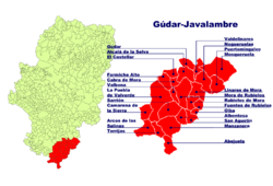
| Comarca | Gúdar-Javalambre |
| Judicial district | Teruel |
| Government | |
| • Alcaldesa | María Luisa Fuertes Alegría (2007) |
| Area | |
| • Total | 282.78 km2 (109.18 sq mi) |
| Elevation | 1,183 m (3,881 ft) |
| Population (2018)[1] | |
| • Total | 453 |
| • Density | 1.6/km2 (4.1/sq mi) |
| Demonym(s) | Pueblano, -a |
| Time zone | UTC+1 (CET) |
| • Summer (DST) | UTC+2 (CEST) |
| Postal code | 44450 |
La Puebla de Valverde is a municipality located in the province of Teruel, Aragon, Spain. According to the 2004 census (INE), the municipality had a population of 508 inhabitants.
This town is located at the feet of the Sierra de Camarena, Sistema Ibérico.
YouTube Encyclopedic
-
1/3Views:2 3171 316721
-
LA PUEBLA. DE VALVERDE
-
La Puebla de Valverde (Te) asociación taurina la tenaza 2015
-
1974 La Puebla de Valverde en el año 1974 - Plaza Mayor - Iglesia Parroquial - Jamón Serrano Teruel
Transcription
See also
References
- ^ Municipal Register of Spain 2018. National Statistics Institute.
External links
- La Puebla de Valverde on Diputación de Teruel Archived 2012-02-20 at the Wayback Machine
This article about a location in the Province of Teruel is a stub. You can help Wikipedia by expanding it. |