
Lüleburgaz District | |
|---|---|
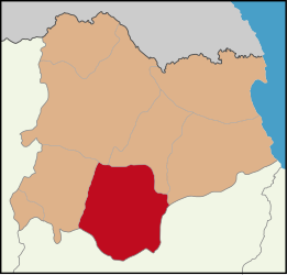 Map showing Lüleburgaz District in Kırklareli Province | |
 Lüleburgaz District Location in Turkey  Lüleburgaz District Lüleburgaz District (Marmara) | |
| Coordinates: 41°24′N 27°21′E / 41.400°N 27.350°E | |
| Country | Turkey |
| Province | Kırklareli |
| Seat | Lüleburgaz |
| Government | |
| • Kaymakam | Salih Yüce |
| Area | 1,016 km2 (392 sq mi) |
| Population (2022) | 153,903 |
| • Density | 150/km2 (390/sq mi) |
| Time zone | UTC+3 (TRT) |
| Website | www |
Lüleburgaz District is a district of the Kırklareli Province of Turkey. Its seat is the city of Lüleburgaz.[1] Its area is 1,016 km2,[2] and its population is 153,903 (2022).[3]
Composition
There are four municipalities in Lüleburgaz District:[1][4]
There are 31 villages in Lüleburgaz District:[5]
References
- ^ a b İlçe Belediyesi, Turkey Civil Administration Departments Inventory. Retrieved 1 March 2023.
- ^ "İl ve İlçe Yüz ölçümleri". General Directorate of Mapping. Retrieved 1 March 2023.
- ^ "Address-based population registration system (ADNKS) results dated 31 December 2022, Favorite Reports" (XLS). TÜİK. Retrieved 13 March 2023.
- ^ Belde Belediyesi, Turkey Civil Administration Departments Inventory. Retrieved 1 March 2023.
- ^ Köy, Turkey Civil Administration Departments Inventory. Retrieved 1 March 2023.
Lüleburgaz District in Kırklareli Province of Turkey | |||||||||||||||||||||||||||
|---|---|---|---|---|---|---|---|---|---|---|---|---|---|---|---|---|---|---|---|---|---|---|---|---|---|---|---|
| Districts |   | ||||||||||||||||||||||||||
|
Metropolitan municipalities are bolded. | |||||||||||||||||||||||||||
| Municipalities | |
|---|---|
| Villages | |
| International | |
|---|---|
| National | |
This geographical article about a location in Kırklareli Province, Turkey is a stub. You can help Wikipedia by expanding it. |