Khalilabad County
Persian: شهرستان خليل آباد | |
|---|---|
 Stream in Khalilabad, summer | |
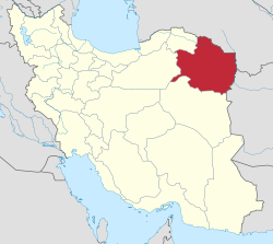
 Location of Khalilabad County in Razavi Khorasan Province (center left, pink) | |
 Location of Razavi Khorasan Province in Iran | |
| Coordinates: 35°10′N 58°12′E / 35.167°N 58.200°E[1] | |
| Country | Iran |
| Province | Razavi Khorasan |
| Capital | Khalilabad |
| Districts | Central, Sheshtaraz |
| Area | |
| • Total | 1,121 km2 (433 sq mi) |
| Population (2016)[2] | |
| • Total | 51,701 |
| • Density | 46/km2 (120/sq mi) |
| Time zone | UTC+3:30 (IRST) |
| Khalilabad County at GEOnet Names Server | |
Khalilabad County (Persian: شهرستان خليل آباد) is in Razavi Khorasan Province, Iran. Its capital is the city of Khalilabad.[3]
Demographics
Population
At the time of the 2006 National Census, the county's population was 44,993 in 12,298 households.[4] The following census in 2011 counted 49,111 people in 14,879 households.[5] At the 2016 census, the county's population was 51,701 in 16,684 households.[2]
Administrative divisions
Khalilabad County's population history and administrative structure over three consecutive censuses are shown in the following table.
| Administrative Divisions | 2006[4] | 2011[5] | 2016[2] |
|---|---|---|---|
| Central District | 26,770 | 30,159 | 31,786 |
| Howmeh RD | 10,231 | 10,587 | 10,594 |
| Rostaq RD | 8,130 | 8,478 | 8,441 |
| Khalilabad (city) | 8,409 | 11,094 | 12,751 |
| Sheshtaraz District | 18,223 | 18,952 | 19,915 |
| Kavir RD | 6,171 | 6,149 | 6,359 |
| Sheshtaraz RD | 6,352 | 6,801 | 7,096 |
| Kondor (city) | 5,700 | 6,002 | 6,460 |
| Total | 44,993 | 49,111 | 51,701 |
| RD = Rural District | |||
See also
![]() Media related to Khalilabad County at Wikimedia Commons
Media related to Khalilabad County at Wikimedia Commons
References
- ^ OpenStreetMap contributors (2 May 2023). "Khalilabad County" (Map). OpenStreetMap. Retrieved 2 May 2023.
- ^ a b c "Census of the Islamic Republic of Iran, 1395 (2016)". AMAR (in Persian). The Statistical Center of Iran. p. 09. Archived from the original (Excel) on 2 April 2022. Retrieved 19 December 2022.
- ^ Aref, Mohammad Reza (29 April 1382). "Letter of approval regarding the changes and reforms of divisions in Khorasan province". Laws and Regulations Portal of the Islamic Republic of Iran (in Persian). Ministry of Interior, Defense Political Commission of the State Council. Archived from the original on 7 January 2024. Retrieved 7 January 2024.
- ^ a b "Census of the Islamic Republic of Iran, 1385 (2006)". AMAR (in Persian). The Statistical Center of Iran. p. 09. Archived from the original (Excel) on 20 September 2011. Retrieved 25 September 2022.
- ^ a b "Census of the Islamic Republic of Iran, 1390 (2011)". Syracuse University (in Persian). The Statistical Center of Iran. p. 09. Archived from the original (Excel) on 20 January 2023. Retrieved 19 December 2022.

