
| Island Creek | |
|---|---|
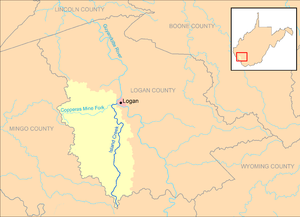 Island Creek and its watershed in Logan County, West Virginia | |
| Location | |
| Country | United States |
| State | West Virginia |
| County | Logan |
| Physical characteristics | |
| Source | |
| • location | Horsepen Mountain, near Mountain View |
| • coordinates | 37°38′44″N 81°59′36″W / 37.6456631°N 81.9934561°W[1] |
| • elevation | 1,837 ft (560 m)[2] |
| Mouth | Guyandotte River |
• location | Logan |
• coordinates | 37°50′55″N 81°59′49″W / 37.8487146°N 81.9970693°W[1] |
• elevation | 663 ft (202 m)[1] |
| Length | 18.1 mi (29.1 km) |
| Basin size | 105 sq mi (270 km2) |
| Basin features | |
| Tributaries | |
| • left | Copperas Mine Fork |
Island Creek is a tributary of the Guyandotte River, 18.1 miles (29.1 km) long,[3] in southern West Virginia in the United States. Via the Guyandotte and Ohio rivers, it is part of the watershed of the Mississippi River, draining an area of 105 square miles (270 km2)[4] in a rural area on the unglaciated portion of the Allegheny Plateau, in the Logan Coalfield. Island Creek's entire course and drainage area are in Logan County.[5]
Island Creek rises on Horsepen Mountain in the southern extremity of Logan County, near the community of Mountain View, and flows generally northward through the unincorporated communities of Crystal Block, Sarah Ann, Stirrat, Barnabus, Superior Bottom, Omar, Chauncey, Micco, Switzer, Rossmore, Monaville, Wilkinson, Monitor, and Mount Gay, to the city of Logan, where it flows into the Guyandotte River opposite Hatfield Island. The creek is paralleled by West Virginia Route 44 for most of its course.[5]
According to the West Virginia Department of Environmental Protection, approximately 94% of the Island Creek watershed is forested, mostly deciduous.[4] Its largest tributary is the Copperas Mine Fork, which drains 43% of Island Creek's watershed;[6] Copperas Mine Fork flows into Island Creek at Mount Gay.[5]
YouTube Encyclopedic
-
1/3Views:156 3021 67657 009
-
Willow Island Disaster
-
Ohio River Islands National Wildlife Refuge, West Virginia 2009 USFWS 7min CC
-
Buffalo Creek Dam Disaster
Transcription
See also
References
- ^ a b c Geographic Names Information System. "Geographic Names Information System entry for Island Creek (Feature ID #1540737)". Retrieved 2011-10-25.
- ^ Google Earth elevation for GNIS source coordinates. Retrieved on 2011-10-25.
- ^ United States Environmental Protection Agency. "Watershed Assessment, Tracking & Environmental Results: Assessment Summary for Reporting Year 2008, West Virginia, Upper Guyandotte Watershed". Archived from the original on 2012-12-12. Retrieved 2011-10-25.
- ^ a b West Virginia Department of Environmental Protection. "Upper Guyandotte River". Watershed Atlas Project. Archived from the original on 2005-04-05. Retrieved 2011-10-25.
{{cite web}}: External link in|work= - ^ a b c West Virginia Atlas & Gazetteer. Yarmouth, Me.: DeLorme. 1997. pp. 51, 57. ISBN 0-89933-246-3.
- ^ West Virginia Department of Environmental Protection. "HUC 8-12 Watersheds" (PDF). Archived from the original (PDF) on 2011-10-12. Retrieved 2011-10-25. HUC 12 watershed 050701010401, totaling 29075.17 acres.