
Eemsmond | |
|---|---|
Former municipality | |
 Flag  Coat of arms | |
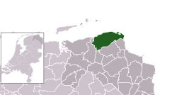 Location in Groningen | |
| Coordinates: 53°24′N 6°40′E / 53.400°N 6.667°E | |
| Country | Netherlands |
| Province | Groningen |
| Established | 1 January 1979 |
| Area | |
| • Total | 543.35 km2 (209.79 sq mi) |
| • Land | 189.81 km2 (73.29 sq mi) |
| • Water | 353.54 km2 (136.50 sq mi) |
| Elevation | 2 m (7 ft) |
| Population (January 2021)[3] | |
| • Total | data missing |
| Postcode | 9979–9989, 9995–9999 |
| Area code | 0595, 0596 |
| Website | www |
Eemsmond (Dutch pronunciation: [ˈeːmsmɔnt] ⓘ; English: Ems Mouth) is a former municipality with a population of 15,864 in the north of the province of Groningen in the northeast of the Netherlands. On 1 January 2019 it merged with the municipalities of Bedum, De Marne and Winsum to form the new municipality Het Hogeland.
YouTube Encyclopedic
-
1/1Views:1 415
-
Gemeente Eemsmond Videoproducties Groningen WeShootit promotiefilm
Transcription
History
The municipality of Hefshuizen was established on 1 January 1979 by merging the municipalities of Uithuizen and Uithuizermeeden. On 1 January 1990, the municipalities of Kantens, Usquert, and Warffum were added. On 1 January 1992, the name of the municipality was changed from Hefshuizen to Eemsmond, which means Ems Mouth.[4]
Geography

Eemsmond is located at 53°24′N 6°40′E / 53.400°N 6.667°E in the north of the province of Groningen and in the northeast of the Netherlands.
The population centers in the municipality are: Eemshaven, Eppenhuizen, Kantens, Oldenzijl, Oosteinde, Oosternieland, Oudeschip, Roodeschool, Rottum, Startenhuizen, Stitswerd, Uithuizen, Uithuizermeeden, Usquert, Warffum, and Zandeweer.
To the north of Eemsmond is the North Sea. Part of the Wadden Sea, a UNESCO World Heritage Site since 2009, is located in the municipality, including the sandbank Simonszand and the uninhabited islands Rottumeroog, Rottumerplaat, and Zuiderduintjes. The northernmost point of the Netherlands is located at Rottumerplaat.
Culture
Eemsmond hosted the start of stage 4 at the 2013 Energiewacht Tour.
Government
Marijke van Beek of the Labour Party (PvdA) was the last mayor of Eemsmond.[5]
Transportation
The Sauwerd–Roodeschool railway connects the railway stations Warffum, Usquert, Uithuizen, Uithuizermeeden, and Roodeschool to the Groningen railway station and the rest of the Dutch railway network.
Notable people

- Willem Surenhuis (c.1664 in Rottum – 1729) a Dutch Christian scholar of Hebrew
- Hendrik Bulthuis (1865 in Warffum – 1945) a Dutch customs official, author and translator of more than thirty works into Esperanto
- Frits Peutz (1896 in Uithuizen – 1974) architect
- Aldert van der Ziel (1910 in Zandeweer – 1991) a Dutch physicist who studied electronic noise processes
- Molly Geertsema (1918–1991) politician and jurist, Mayor of Warffum 1953-1957
- Seth Gaaikema (1939 in Uithuizen – 2014) cabaret artist, writer, and lyricist
- Ede Staal (1941 in Warffum – 1986) a Dutch singer-songwriter, sang mainly in Gronings dialect
References
- ^ "Kerncijfers wijken en buurten 2020" [Key figures for neighbourhoods 2020]. StatLine (in Dutch). CBS. 24 July 2020. Retrieved 19 September 2020.
- ^ "Postcodetool for 9981AA". Actueel Hoogtebestand Nederland (in Dutch). Het Waterschapshuis. Retrieved 20 January 2014.
- ^ "Bevolkingsontwikkeling; regio per maand" [Population growth; regions per month]. CBS Statline (in Dutch). CBS. 1 January 2021. Retrieved 2 January 2022.
- ^ (in Dutch) Ad van der Meer & Onno Boonstra, Repertorium Nederlandse gemeenten vanaf 1812, 2e editie Archived 14 April 2021 at the Wayback Machine, Data Archiving and Networked Services, 2011. Retrieved 21 August 2015.
- ^ "Samenstelling college" [Members of the board] (in Dutch). Gemeente Eemsmond. Archived from the original on 3 February 2014. Retrieved 20 January 2014.
External links
- (in Dutch) Official website
Places adjacent to Eemsmond | ||||||||||||||||
|---|---|---|---|---|---|---|---|---|---|---|---|---|---|---|---|---|
| ||||||||||||||||
| International | |
|---|---|
| Geographic | |
This Groningen location article is a stub. You can help Wikipedia by expanding it. |