
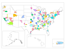
A core-based statistical area (CBSA) is a U.S. geographic area defined by the Office of Management and Budget (OMB). It contains a large population nucleus, or urban area, and adjacent communities that have a high degree of integration with that nucleus.[1]
On July 15, 2015, the OMB released new standards based on the 2010 census.[2][3][4] These standards are used to replace the definitions of metropolitan areas from the 2010 United States census data.
YouTube Encyclopedic
-
1/5Views:52 4821 8271 054 3591 932 573350 072
-
Introduction to CORe
-
Metropolitan statistical area
-
Z-Scores, Standardization, and the Standard Normal Distribution (5.3)
-
Standard Normal Distribution Tables, Z Scores, Probability & Empirical Rule - Stats
-
How To...Calculate the Confidence Interval for a Sample
Transcription
Definition
The term "CBSA" refers collectively to both metropolitan statistical areas and micropolitan areas. Micropolitan areas are based on Census Bureau-defined urban clusters of at least 10,000 and fewer than 50,000 people.
The basic definition of metropolitan areas slightly changed.[when?] A metropolitan area, as it did in 1990, requires a Census Bureau-defined urbanized area of at least 50,000 people. A metropolitan statistical area containing an urbanized area of at least 2.5 million people can be subdivided into two or more "metropolitan divisions", provided specified criteria are met. Metropolitan divisions are conceptually similar to the primary metropolitan statistical areas (PMSAs) defined under previous standards.
Similarly, there are now definitions for combined statistical areas (CSAs). These areas can be formed when adjoining CBSAs meet particular standards to become new areas. Any combination of metro and micro areas may be used to form a CSA.
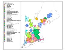
The metropolitan areas in New England became county-based, consistent with the rest of the U.S. Previously, these were referred to by the Census Bureau as New England county metropolitan areas (NECMA) and were separate from the normal census counts for the areas, based on cities and towns. They have essentially swapped places now, with the city and town areas (or NECTAs, for New England city and town areas) being the separate listings.
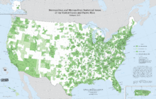
Not much changed in the basic definition, but 49 new metropolitan areas were formed.[when?] Over 550 other areas were classified as micropolitan. The rules have defined 935 CBSAs in the U.S. and Puerto Rico. Eleven of the CBSAs have metropolitan divisions, 29 in total. In comparison, the definition of metropolitan areas in 1999, the last year areas were formed based on the 1990 rules for them, has 284 metropolitan areas, with 19 of the areas providing 76 primary metropolitan areas (the equivalent of divisions). Almost three times the number of areas overall are recognized by the OMB.
See also
- Outline of the United States
- Index of United States-related articles
- Demographics of the United States
- United States Census Bureau
- United States Office of Management and Budget
- Statistical area (United States)
- Combined statistical area (list)
- Core-based statistical area (list)
- Statistical area (United States)
References
- ^ 2010 Standards for Delineating Metropolitan and Micropolitan Statistical Areas
- ^ "2010 Census Summary File 1 Technical Documentation" (PDF). September 2012. p. 619.
- ^ "GreatData.com". Retrieved March 22, 2013.
- ^ "OMB" (PDF). Office of Management and Budget. Archived (PDF) from the original on January 21, 2017. Retrieved November 12, 2015 – via National Archives.
External links
 Definitions from Wiktionary
 Media from Commons
 News from Wikinews
 Quotations from Wikiquote
 Texts from Wikisource
 Textbooks from Wikibooks
 Resources from Wikiversity