
Kongo Central
| |
|---|---|
 Zongo Falls on the Inkisi River | |
 Seal | |
 | |
| Coordinates: 05°49′S 13°29′E / 5.817°S 13.483°E | |
| Country | |
| Capital and largest city | Matadi |
| Government | |
| • Body | Provincial Assembly of Kongo Central |
| • Governor | Guy Bandu Ndungidi[1] |
| Area | |
| • Total | 53,920 km2 (20,820 sq mi) |
| Population (2020) | |
| • Total | 6,838,500 |
| • Density | 130/km2 (330/sq mi) |
| Time zone | UTC+1 (West Africa Time) |
| License Plate Code | |
| Official language | French |
| National languages | Kikongo ya Leta, lingala[2] |
| HDI (2017) | 0.432[3] low |
| Non-national language | Kikongo |
Kongo Central (Kongo: Kongo dia Kati[4][5]), formerly Bas-Congo, is one of the 26 provinces of the Democratic Republic of the Congo.[6] Its capital is Matadi.
YouTube Encyclopedic
-
1/2Views:1 15517 112
-
EP MAYEMBA KONGO CENTRAL
-
KONGO CENTRAL : Visite des chutes de Zongo et Street Food l 🇨🇩CONGO KINSHASA TRAVEL VLOG (3/4)
Transcription
History
At the time of independence, the area now encompassing Kongo Central was part of the greater province of Léopoldville, along with the capital city of Kinshasa and the districts of Kwango, Kwilu and Mai-Ndombe. Under Belgian colonial rule, the province was known as Bas-Congo (as in "Lower Congo River") and was renamed Kongo Central after independence.[7][8]
Under the regime of Mobutu Sese Seko from 1965 to 1997, the Congo river was renamed as Zaire. The province was named as Bas-Zaïre. The name was later reverted to Bas-Congo. It was subsequently renamed as Kongo Central in 2015.
Geography


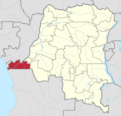
Kongo Central is the only province in the country with an ocean coastline; it has narrow frontage on the Atlantic Ocean. It borders the provinces of Kinshasa to the north-east, Kwango to the east, and the Republic of Angola to the south as well as the Republic of the Congo and Cabinda to the north.
Divisions
The provincial capital is Matadi. The only other official city is Boma. The remainder of the province is administratively divided into ten territories, the most of any province:[9]
Before 2015 these territories were divisions of the Bas-Fleuve, Cataractes and Lukaya districts; except for Moanda, which was attached to Boma (a city/district hybrid).[10]
Towns with their 2010 populations are:
Notable people from Kongo Central
- Afonso I of Kongo, the sixth ruler of the Kingdom of Kongo.
- Paul Panda Farnana, first Congolese with Belgian diploma of higher education.
- Joseph Kasa-Vubu, Democratic Republic of the Congo first president.
- Simon Kimbangu, founder of Christian new religious movement Kimbanguism.
- Writer Zamenga Batukezanga was born in Kongo Central.
- Thomas Kanza, Congolese diplomat. He was one of the first Congolese nationals to graduate from a university.
- Ne Muanda Nsemi, Bundu dia Kongo leader.
- Franco Luambo Makiadi, virtuoso Congolese Rumba guitarist and singer.
- Ray Lema, France-based pianist, guitarist, and songwriter.
- Sophie Kanza, first Congolese woman to obtain a university degree (politician and sociologist).
- Longo-Mbenza Benjamin, Professor of Medicine, Cardiologist.
References
- ^ "Guy Bandu promet de faire du Kongo-Central le poumon économique de la RDC". Radio Okapi (in French). 21 June 2022. Retrieved 21 June 2022.
- ^ "Kongo-central : le kikongo en voie de disparition, le lingala gagne progressivement du terrain [Enquête]". L'Opinion Info (in French).
Le lingala est fortement utilisé dans les milieux des enfants et des jeunes, tandis que le Kikongo est principalement utilisé chez les vieilles personnes.
[Lingala is used extensively among children and youth, while Kikongo is used primarily among older people.] - ^ "Sub-national HDI - Area Database - Global Data Lab". hdi.globaldatalab.org. Retrieved 2018-09-13.
- ^ M. J. Hambrey and W. B. Harland, Earth's Pre-Pleistocene Glacial Record, Cambridge University Press, 2011, p. 157
- ^ Godefroid Muzalia Kihangu, Bundu dia Kongo, une résurgence des messianismes et de l’alliance des Bakongo?, Universiteit Gent, België, 2011, p. 1
- ^ Central Intelligence Agency (2016). "Democratic Republic of the Congo". The World Factbook. Langley, Virginia: Central Intelligence Agency. Retrieved 10 May 2016.
- ^ "Constitution de la République Démocratique du Congo du 1er août 1964" [Constitution of the Democratic Republic of the Congo of 1 August 1964]. Global Legal Information Network (in French). 1964. Archived from the original on 2 August 2012. Retrieved 22 May 2012. (Article 4)
- ^ "Constitution de la République Démocratique du Congo du 24 juin 1967" [Constitution of the Democratic Republic of the Congo of 24 June 1967]. Global Legal Information Network (in French). 1967. Archived from the original on 2 August 2012. Retrieved 22 May 2012. (Article 1)
- ^ Institut National de la Statistique–RD Congo (March 2017). Annuaire statistique 2015 [2015 Statistical Yearbook] (PDF) (in French). pp. 8-9 Tableau 1.3. Archived (PDF) from the original on 13 October 2022. Retrieved 2 Jan 2023.
- ^ Institut National de la Statistique–RD Congo (July 2015). Annuaire statistique 2014 [2014 Statistical Yearbook] (PDF) (in French). pp. 36–38 Tableau 1.5. Archived from the original (PDF) on 12 Mar 2019. Retrieved 3 January 2023.
- ^ a b "Bas-Congo: largest cities and towns and statistics of their population". World Gazetteer. Archived from the original on 2012-12-16.
Bibliography
- Gillet, J. (1927) Catalogue des plantes du jardin d'essais de la mission de Kisantu. Bruxelles 166 pp.
- Pauwels, L. (1993) Nzayilu N'ti – guide des arbres et arbustes de la région de Kinshasa – Brazzaville. Meise ISBN 9072619102, 495 pp.
- Latham, P. (2003) Edible caterpillars and their food plants in Bas-Congo Mystole Publications. ISBN 0954301277, 60 pp.
- Kibungu Kembelo, A.O. (2004) Plantes medicinales du Bas-Congo et leurs usages DFID. 197 pp.
- Latham, P. (2004) Useful plants of Bas-Congo province DFID. ISBN 0954669835, 320 pp.
- Latham, P. (2008) Les chenilles comestibles et leurs plantes nourricières dans la province du Bas-Congo DFID. ISBN 9780955420863,44 pp.
- Latham, P. et Konda ku Mbuta, A. (2010) Plantes utiles du Bas-Congo. Mystole Publications. ISBN 9780955420818, 372 pp.
- Latham, P. et Konda ku Mbuta, A. (2011) Some honeybee plants of Bas-Congo province DFID. ISBN 9780955420894, 248 pp.
- Latham, P. & Konda ku Mbuta, A. (2014) Useful plants of Bas-Congo province ISBN 9780955420870, 553 pp.
| Cities | |
|---|---|
| Territories | |
| Populated places | |
| Other | |
| National | |
|---|---|
| Geographic | |