
Coatepec | |
|---|---|
City and municipality | |
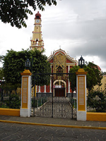
     Top: Aerial view of Coatepec Downtown; Middle: Coatepec Municipal Hall, Old houses at Coatepec downtown; Bottom: Coatepec main plaza, San Jerónimo Church | |
 Coat of arms | |
 Coatepec Location in Mexico  Coatepec Coatepec (Mexico) | |
| Coordinates: 19°27′08″N 96°57′41″W / 19.45222°N 96.96139°W | |
| Country | |
| State | Veracruz |
| Region | Capital Region |
| Municipal seat and largest town | Coatepec |
| Government | |
| • Mayor | Raymundo Andrade Rivera (MORENA) |
| Area | |
| • Municipality | 202.4 km2 (78.1 sq mi) |
| Elevation (of seat) | 1,192 m (3,911 ft) |
| Population (2020) | |
| • Municipality | 93,911 |
| • Density | 463.9/km2 (1,201/sq mi) |
| • Seat | 55,720 |
| Time zone | UTC-6 (Central (US Central)) |
| • Summer (DST) | UTC-5 (Central) |
| Postal code (of seat) | 30128 |
| Climate | ET |
| Website | (in Spanish) |
| Year | Pop. | ±% |
|---|---|---|
| 1995 | 70,430 | — |
| 2000 | 73,536 | +4.4% |
| 2005 | 79,787 | +8.5% |
| 2010 | 86,696 | +8.7% |
| 2015 | 92,127 | +6.3% |
| 2020 | 93,911 | +1.9% |
| [1] | ||


The municipality of Coatepec (Spanish: [koateˈpek] ⓘ) is located in the central region of the Mexican state of Veracruz. Its north latitude is 19° 27′, west longitude is 96° 58′, altitude of 1,200.00 m (3,937.01 ft), and surface of 202.4 km2 (78.1 sq mi). It represents the 0.338% of the current state. The municipal seat and largest community of the municipality is also called Coatepec. The Mexican census of 2020 reported a population of 55,720 in the city, while the municipality had 93,911 inhabitants.[1] The municipality also includes many smaller communities within its boundaries. The largest of these are Tuzamapan, (8,300 hab.), Pacho Viejo (4,829 hab.), and Mahuixtlán (3,946 hab.)[1].
Often called The Coffee Capital of Mexico, the name Coatepec comes from the Nahuatl coatl (serpent), and tepetl (hill), or "The Hill of the Snakes".
Coatepec was named a "Pueblo Mágico" in 2006.
YouTube Encyclopedic
-
1/3Views:56 92348 31547 992
-
Coatepec, que hacer en un fin de semana
-
Coatepec - AXM
-
Coatepec, Veracruz - Pueblo Mágico 2007
Transcription
Geography
Coatepec borders the municipalities of Xalapa and Tlalnelhuayocan (north); Teocelo and Jalcomulco (south); Emiliano Zapata (east); and Xico and Teocelo (west).
This municipality has four small rivers: the Pixquiac, the Pintores, the Sordo and the Hueyapan; all flow into the Pescados (La Antigua) River.
Climate
Coatepec's yearly median temperature is 19.5 °C (67 °F). Seasonal variations in temperature are moderate as elsewhere in central Mexico, whilst precipitation has more pronounced changes. The warmest month is May, when temperatures top 30 °C (86 °F) on average, although at night because of the high elevation the mercury drops to 15 °C (59 °F). The coolest month is January with temperatures varying from 9 °C (48 °F) to 22 °C (72 °F). Precipitation is at its lowest during the spring months (however still some rainfall falls from late cold fronts or early thunderstorm activity). Rainfall peaks at two times during the year, in June, at the beginning of the rainy season, and in September, towards the end of it. During these months precipitation exceeds on average 300 mm (11.8 in) and have been as high as over 25 in (640.7 mm in September 1974). The city's mild to warm temperatures have their extremes in 33 °C (92 °F) in May 1984 and -1 °C (28 °F) during February, 1976. There are 161 days with rain each year, while fog is common during the winter months.
| Coatepec | ||||||||||||||||||||||||||||||||||||||||||||||||||||||||||||
|---|---|---|---|---|---|---|---|---|---|---|---|---|---|---|---|---|---|---|---|---|---|---|---|---|---|---|---|---|---|---|---|---|---|---|---|---|---|---|---|---|---|---|---|---|---|---|---|---|---|---|---|---|---|---|---|---|---|---|---|---|
| Climate chart (explanation) | ||||||||||||||||||||||||||||||||||||||||||||||||||||||||||||
| ||||||||||||||||||||||||||||||||||||||||||||||||||||||||||||
| ||||||||||||||||||||||||||||||||||||||||||||||||||||||||||||
Culture
Coatepec has many traditions, with the most important being The Feast of Sán Jerónimo, which the people celebrate on September 30 each year.
The foods in Coatepec that are the most popular with the local population and tourists alike include: Tamales, Chilaquiles, Emmoladas, Gorditas, Lupitas, Enfrijoladas, and others.
Products
Coatepec is known for its coffee, which both tastes and looks appealing.
References
- Link to tables of population data from Census of 2005 INEGI: Instituto Nacional de Estadística, Geografía e Informática
- Veracruz Enciclopedia de los Municipios de México
External links
- Ayuntamiento de Coatepec Official website for the 2005-2007 administration
- Site with Tourist information about Coatepec
- Site of government Current administration
- (in Spanish) Municipal Official Information
- Cultural festival
- Geographical information in Tagzania
- El Retoño Ecolodge