
Nickname: The Emerald Isle of the Caribbean | |
|---|---|
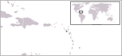
 Map of Montserrat | |
 | |
| Geography | |
| Location | Caribbean Sea |
| Coordinates | 16°45′N 62°12′W / 16.750°N 62.200°W |
| Archipelago | Leeward Islands |
| Area | 102 km2 (39 sq mi) |
| Coastline | 39.8 km (24.73 mi) |
| Highest elevation | 914.2 m (2999.3 ft) |
| Highest point | Chances Peak (in the Soufrière Hills) |
| Administration | |
United Kingdom | |
| British Overseas Territory | Montserrat |
| Largest settlement | Brades (pop. 1,000) |
| Demographics | |
| Population | 4,488 |
| Pop. density | 44.88/km2 (116.24/sq mi) |

Montserrat is an island in the Caribbean Sea, in the Leeward Islands. Its nearest neighbours in the island chain include Guadeloupe to the southeast, Antigua to the north-east and Nevis to the northwest. The island is 16 km (9.9 mi) long and 11 km (6.8 mi) wide, with a coastline of about 40 km.
The island is volcanic and largely mountainous. The Soufrière Hills volcano became active in 1995, causing widespread devastation, including the destruction of the capital and formerly largest settlement on the island, Plymouth. The southern part of the island is now uninhabitable and human settlement is constrained to the north.
Montserrat has two islets, Little Redonda and Virgin, as well as Statue Rock.
YouTube Encyclopedic
-
1/3Views:21 8061 058 603759 138
-
7 Facts about Montserrat
-
CARIBBEAN EXPLAINED! (Geography Now!)
-
Geography Now! Antigua and Barbuda
Transcription
Climate
Montserrat has a tropical climate, with little daily or seasonal temperature variation.
| Climate data for Plymouth | |||||||||||||
|---|---|---|---|---|---|---|---|---|---|---|---|---|---|
| Month | Jan | Feb | Mar | Apr | May | Jun | Jul | Aug | Sep | Oct | Nov | Dec | Year |
| Record high °C (°F) | 32 (90) |
33 (91) |
34 (93) |
34 (93) |
36 (97) |
37 (99) |
37 (99) |
37 (99) |
36 (97) |
34 (93) |
37 (99) |
33 (91) |
37 (99) |
| Mean daily maximum °C (°F) | 29 (84) |
30 (86) |
31 (88) |
31 (88) |
32 (90) |
32 (90) |
33 (91) |
33 (91) |
32 (90) |
31 (88) |
30 (86) |
29 (84) |
31 (88) |
| Mean daily minimum °C (°F) | 23 (73) |
23 (73) |
24 (75) |
24 (75) |
24 (75) |
25 (77) |
25 (77) |
25 (77) |
24 (75) |
24 (75) |
24 (75) |
23 (73) |
24 (75) |
| Record low °C (°F) | 17 (63) |
18 (64) |
18 (64) |
18 (64) |
19 (66) |
21 (70) |
22 (72) |
22 (72) |
21 (70) |
19 (66) |
19 (66) |
18 (64) |
17 (63) |
| Average precipitation mm (inches) | 122 (4.8) |
86 (3.4) |
112 (4.4) |
89 (3.5) |
97 (3.8) |
112 (4.4) |
155 (6.1) |
183 (7.2) |
168 (6.6) |
196 (7.7) |
180 (7.1) |
140 (5.5) |
1,640 (64.6) |
| Source: BBC Weather[1] | |||||||||||||
Statistics
Location: About 500 km southeast of Puerto Rico
Maritime claims:
Territorial sea:
3 nmi (5.556 km; 3.452 mi)
Exclusive fishing zone:
200 nmi (370.4 km; 230.2 mi)
Terrain: Volcanic islands, mostly mountainous, with small coastal lowland
Elevation extremes:
Lowest point:
Caribbean Sea 0 m
Highest point:
Prior to 1995, the highest point was Chances Peak (in the Soufrière Hills) at 915 m. Ongoing volcanic activity has created a lava dome estimated at 1,050 m in 2013.[2]
Natural resources: Negligible
Land use:
Arable land:
20%
Permanent crops:
0%
Other:
80% (2011)
Natural hazards: Severe hurricanes (June to November); volcanic eruptions
Environment - current issues: Land erosion occurs on slopes that have been cleared for cultivation.[3]
References
- ^ "Average Conditions Plymouth, Montserrat". BBC Weather. Archived from the original on 30 November 2010. Retrieved 14 July 2010.
- ^ "The CIA World Factbook - Montserrat". Retrieved 2015-07-11.
- ^ Hodder Education A-Level Textbook
Sources
| Sovereign states |  | |
|---|---|---|
Dependencies and other territories | ||
This Montserrat location article is a stub. You can help Wikipedia by expanding it. |