
The city walls of Paris (French: enceintes de Paris or murs de Paris) refers to the city walls that surrounded Paris, France, as it grew from ancient times until the 20th century, built primarily to defend the city but also for administrative reasons. Several successive city walls were built over the centuries, either adding to existing walls or replacing demolished ones, through 1846, when construction of the Thiers wall was completed.
YouTube Encyclopedic
-
1/3Views:1 077 47750 0971 387 427
-
The city of walls: Constantinople - Lars Brownworth
-
Why are Walled Cities Round?
-
Did ancient Troy really exist? - Einav Zamir Dembin
Transcription
The most important walls in western history aren't even in the West. They surround the modern city of Istanbul, Constantinople as the Romans called it. And for a thousand years, the fate of Europe depended on them. Constantinople was designed to be the center of the world. When the frontiers of the Roman Empire began to crumble in the 4th Century, the capital was moved to the cultured, wealthy, and still stable East. There, at the crossroads between Europe and Asia, the hub of the major trade routes of the ancient world, the Emperor Constantine built his city. This was the city of libraries and universities, 20 times the size of London or Paris at the time. It contained the priceless knowledge of the classical world which was fading in the West. To protect this masterpiece from its many enemies, Constantine's successors built the finest defensive fortifications ever made. The first line of protection was a moat 60 feet wide and 22 feet deep, stretching all four miles from coast to coast. Pipes from inside the city could fill it at the first sight of the enemy, and a short wall protected archers who could fire at the soaked soldiers trying to swim across. Those who were lucky enough to clear the moat had to contend with an unceasing barrage from the 27 foot outer wall above. Arrows, spears, or far worse, Greek fire -- an ancient form of napalm that would ignite on contact and couldn't be extinguished by water -- would rain down on them. Squads of Roman defenders would carry portable flame throwers, spraying anyone trying to climb out of the moat. The terrified victims would leap back, only to find that they still burned underwater. At times, the Romans would also mount siphons onto the ramparts, and launch clay pots full of Greek fire from catapults at an invading army. The front lines would turn into an inferno, making it appear as if the earth itself was on fire. If, by some miracle, the outer wall was compromised, attackers would be faced with the final defense: the great inner wall. These walls were wide enough to have four men ride side by side, allowing troops to be rushed wherever they were needed. Attilla the Hun, destroyer of civilizations, who named himself the Scourge of God, took one look at them and turned around. The Avars battled the walls uselessly til their catapults ran out of rocks. The Turks tried to tunnel under them, but found the foundations too solid. The Arabs tried to starve the city into submission, but ran out of food themselves and had to resort to cannibalism. It took the guns of the modern world to finally bring them down. In 1453, the Turks brought their super weapon: a monster cannon that could fire a 15 hundred pound stone ball over a mile. Together with more than a hundred smaller guns, they kept up a steady bombardment day and night. A section of the old walls collapsed, but even in their death throes they proved formidable. The rubble absorbed the shock of the cannonballs better than the solid wall. It took a month and a half of continuous blasting to finally open a breach. The last Roman Emperor, Constantine the 11th, drew his sword and jumped into the gap to stop the onrushing horde, disappearing into legend. The city was taken, and the Roman Empire finally disappeared. But those broken walls had one last gift. As the survivors fled the doomed city, they brought with them their precious books and their ancient traditions. They traveled west to Italy, reintroduced the Greek language and learning to western Europe, and ignited the Renaissance. Thanks to Constantinople's walls, that pile of brick and marble that guarded them for so long, we still have our classical past.
Overview
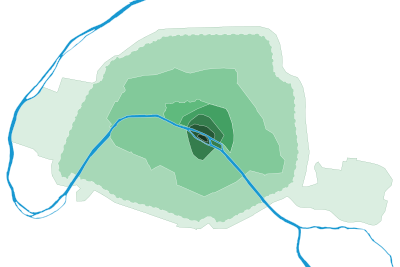
The city walls of Paris include:
- a Gaulish enclosure (precise location unknown)
- a Gallo-Roman wall
- two medieval walls, one of which was the Wall of Philip II Augustus
- the Wall of Charles V, extending on the right bank of the River Seine
- the Louis XIII Wall, extending on the western part of the right bank
- the Wall of the Farmers-General, for tax purposes
- the Thiers wall.
As Paris rapidly expanded to become one of the largest cities in Europe, new walls were built to consolidate the existing city with new houses, gardens, and vegetable fields. Many historical walls were eventually destroyed (as in 1670, when Louis XIV ordered the demolition of the Louis XIII Wall), and the paths formerly occupied by the walls were often repurposed into streets or boulevards. Only a few sections of the Wall of the Farmers-General (pavilions of Claude Nicolas Ledoux) and the Wall of Philippe Auguste survive to the present day. The walls' influence on modern Paris can still be seen on some of its major streets and boulevards, such as:
- the Grands boulevards (main streets), built by replacing the Charles V and Louis XIII Walls
- the parallel streets Rue de Cléry and Rue d'Aboukir (2nd Arrondissement), tracing the route of the Charles V Wall
- the outer boulevards, built in place of the Wall of the Farmers-General
- the Boulevards of the Marshals, a loop encircling the city consisting of boulevards named for the Marshals of France, built to replace the Thiers wall
- the Boulevard Périphérique (ring road or beltway), built beyond the loop of the Boulevards of the Marshals.
Gaulish enclosure
Prior to the Roman occupation of Gaul, the settlement that eventually became the city of Paris was known to the Romans as Lutetia and inhabited by the Parisii tribe. The town lacked proper defenses and was therefore partially demolished at the beginning of the Roman occupation. The first wall of Paris was probably built by the Gauls on the River Seine, although its exact location is unknown. In his Commentaries on the Gallic War, Julius Caesar wrote: "Id est oppidum Parisiorum, quod positum est in insula fluminis Sequanae" ("This is a town of the Parisii, situated on an island on the river of the Seine"), indicating that Lutetia was a fortified camp on an island. The relationship between this island and the Île de la Cité has not been demonstrated, and excavations have not uncovered anything predating the reign of Augustus, the first Roman Emperor.[citation needed] Adding to the uncertainty is the 2003 discovery of the remains of a city on a site now occupied by Nanterre.
Gallo-Roman wall
Lutetia developed on the left bank of the Seine during Roman times, and to a lesser extent on the Île de la Cité. The right bank was largely uninhabitable due to marshes. During the first barbarian invasions in AD 285, the people of Lutetia abandoned the left bank, taking refuge on the Île de la Cité and destroying the bridges. The eastern half of the island was protected by a wall, constructed of rocks collected from the Arènes de Lutèce.
First medieval wall
Traces of an enclosure at the corner of the rue de l'Arbre-Sec and the rue de Rivoli were discovered in 2009 during excavations made by Institut national de recherches archéologiques préventives (INRAP), the French National Institute for Preventive Archaeological Research.[1] This confirmed the probable existence of an enclosure around the centre of Paris on the right bank around the 10th century. This wall was most likely built as a result of a Viking siege in 885 and was constructed by either Odo of France or Robert I of France. The fortification wall consisted of a ditch 3-metre (9.8 ft) deep and 12-metre (39 ft) wide coupled with a raised bank likely topped by a timber pallisade.
Wall of Philip Augustus

Paris grew very quickly during the early Middle Ages and soon extended from the Montagne Sainte-Geneviève to the roads leading to the abbey of Saint-Denis. A new wall was begun in 1190 on the order and funding of King Philip II of France (also known as Philip Augustus) and was completed by 1213,[2] enclosing 253 hectares on both sides of the Seine. This new wall was 8 feet (2.4 m) thick in some places, protected by wide and deep ditches, and was fortified with as many as five hundred towers.
The Wall of Philippe Auguste ran from the current location of the Pont des Arts, approached the porte Saint-Honoré, opened at the porte Coquillière, reached the porte Saint-Denis, porte Mauconseil, porte Babette, came to rue Vielle-du-Temple, the rue des Francs-Bourgeois, to the porte Baudoyer and the quai des Célestins. On the south side, the wall picked up at the Palais de la Tournelle, opened at the porte Saint-Victor, porte Bordet, porte Saint-Jacques, Porte Saint-Michel, porte des Corderliers, near the cour de la Commerce, the porte de Buci, and ended at the Tour de Nesle. Many elements of the wall's structure were later incorporated into private buildings or into the subsequent Wall of Charles V.
Wall of Charles V
The Wall of Charles V was built from 1356 to 1383, during the reign of Charles V and his son and successor Charles VI. The area enclosed on the left bank remained the same as with the Wall of Philippe Auguste, but the area enclosed on the right bank increased to include the mansions of the Marais and the Templar enclosure. The new city limits totaled 439 hectares across the two banks. During the construction of the Wall of Louis XIII, the Wall of Charles V was partly incorporated into the new wall and partly destroyed.
Louis XIII Wall

The Louis XIII Wall, also known as the "yellow ditches wall", was designed by Jacques Lemercier and built between 1633 and 1636. It enlarged the Wall of Charles V over the western part of the right bank (now the First and Second Arrondissements).
From 1670 onward, Louis XIV believed that Paris had been made a secure city as a result of his conquests, and he therefore ordered the wall destroyed. Its route was later replaced with the grands boulevards.
Wall of the Farmers-General
The Wall of the Farmers-General was built in the years between 1784 and 1791 under the direction of Claude Nicolas Ledoux and at the request of the Ferme Générale. It enclosed 3,402 hectares, including the village of Austerlitz, which was incorporated into Paris in 1818. Unlike previous walls, the goal of this wall was not to defend Paris, but to collect taxes and fees on behalf of the government which caused much resentment from the public.[3] It was destroyed when the city limits were extended to the Thiers wall in 1860.
This wall was later replaced by a second belt of boulevards: Charonne, Ménilmontant, Belleville, La Villette, La Chapelle, Clichy, Batignolles, Courcelles, avenue de Wagram and Iena, streets Benjamin Franklin and Alboni, boulevard de Grenelle, Garibaldi, Pasteur, Montparnasse, Edgar Quinet, Raspail, Saint-Jacques, Auguste-Blanqui, Vincent Auriol, Bercy, and Picpus.
Thiers Wall
The Thiers wall was constructed from 1841 to 1846 after being proposed by prime minister and future President of France Adolphe Thiers. It enclosed 7,802 hectares along the present-day Boulevards des Maréchaux and a glacis extending to the location of today's Boulevard Périphérique. It was demolished between 1919 and 1929.
-
 The poterne des Peupliers, the only remaining trace of the Thiers wall
 -
 The porte de Pantin about 1908
 -
 The fortifs zone, in Saint-Ouen
See also
References
- ^ "Site archéologique : Sur les traces de la première enceinte médiévale de Paris | Inrap". Inrap (in French). 25 January 2011. Retrieved 17 January 2018.
- ^ Jones, Colin (6 April 2006). Paris: Biography of a City. Penguin Adult. pp. 53–54. ISBN 978-0-14-028292-4.
- ^ Bryson, Bill (2004). A Short History of Nearly Everything. Great Britain: Black Swan. p. 133.
Bibliography
- Renaud Gagneux et Denis Prouvost, Sur les traces des enceintes de Paris, Parigramme, 2004.
- Jacques Hillairet, Dictionnaire historique des rues de Paris.
- Guy le Hallé, Histoire des fortifications de Paris et leur extension en Île-de-France, Éditions Horvath, 1995.
- Guy le Hallé, in « Paris aux cent villages », mensuel (mai 1975–janvier 1982) :
External links
- (in French) Paris walls (with a map)
- (in French) Guy Le Hallé, The history of "fortifications" (Thiers wall) à Saint-Ouen Archived 15 November 2008 at the Wayback Machine