
Sântămăria-Orlea | |
|---|---|
 Sântămăria-Orlea | |
 Coat of arms | |
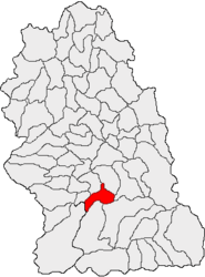 Location in Hunedoara County | |
 Sântămăria-Orlea Location in Romania | |
| Coordinates: 45°35′26″N 22°58′14″E / 45.5906°N 22.9706°E | |
| Country | Romania |
| County | Hunedoara |
| Government | |
| • Mayor (2020–2024) | Dumitru-Ioan Oprean[ (PSD) |
| Area | 67.80 km2 (26.18 sq mi) |
| Elevation | 310 m (1,020 ft) |
| Population (2021-12-01)[1] | 3,132 |
| • Density | 46/km2 (120/sq mi) |
| Time zone | EET/EEST (UTC+2/+3) |
| Postal code | 337440 |
| Area code | (+40) 02 54 |
| Vehicle reg. | HD |
| Website | www |
Sântămăria-Orlea (Hungarian: Őraljaboldogfalva, German: Liebfrauen) is a commune in Hunedoara County, Transylvania, Romania. It is composed of nine villages: Balomir (Balomir), Bărăștii Hațegului (Baresd), Bucium-Orlea (Bucsum), Ciopeia (Csopea), Săcel (Szacsal), Sânpetru (Szentpéterfalva), Sântămăria-Orlea, Subcetate (Hátszegváralja), and Vadu (Vád).
The commune lies in a hilly area, north of the Retezat Mountains, on the banks of the river Strei and its tributary, Râul Mare, as well as the latter's tributaries, Râul Galben and Sibișel.
Sântămăria-Orlea is located in the southern part of Hunedoara County, 40 km (25 mi) south of the county seat, Deva. It is situated in the historical and ethnographical area known as Țara Hațegului, 3 km (1.9 mi) southeast of its hub, the town of Hațeg. The commune is crossed by national road DN66, part of European route E79.
The Kendeffy Castle in Sântămăria-Orlea dates back to 1792; it has been transformed into a hotel in 1982.
Sânpetru Formation
Near Sânpetru, one of the villages comprising the commune, Sânpetru Formations (Sânpetru Beds) are located.
References
-
 Kendeffy Castle in Sântămăria-Orlea
 -
 Reformed church in Sântămăria-Orlea
| Authority control databases: Geographic |
|---|
This Hunedoara County location article is a stub. You can help Wikipedia by expanding it. |