
| Cerro de las Ánimas | |
|---|---|
 Cerro de las Ánimas viewed from a road (Ruta Interbalnearia) | |
| Highest point | |
| Elevation | 501 m (1,644 ft) |
| Coordinates | 34°45′07.38″S 55°19′10.54″W / 34.7520500°S 55.3195944°W |
| Naming | |
| English translation | Hill of the Souls |
| Language of name | Spanish |
| Pronunciation | Spanish: [ˈsero ðelaˈsanimas] |
| Geography | |
 Cerro de las Ánimas Location in Uruguay | |
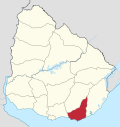
| Location | Piriápolis, Maldonado Department, Uruguay |
| Parent range | Sierra de las Ánimas (part of Cuchilla Grande) |
| Geology | |
| Age of rock | Precambrian |
| Mountain type | Hill |
| Climbing | |
| Easiest route | Hike |
Cerro de las Ánimas ("Hill of the Souls", formerly known as Mirador Nacional) is a peak and the second highest point of Uruguay, with an altitude of 501 metres (1,643.7 ft).
YouTube Encyclopedic
-
1/3Views:3 7696004 638
-
Die Pozos Azules in der Sierra de las Animas bei Piriápilis
-
Ascenso Cerro Las Animas, Iglesias Unidas de Tandil
-
La Gloria, Veracruz. Cerro de las Animas-Gruta de Coamila
Transcription
Location and features
It is located to the southwest of the Maldonado Department, in the municipality of Piriápolis, in a similarly named range of hills which is named Sierra de las Ánimas.
Changing height calculations
Until 1973, this hill was considered the highest point of Uruguay.
However, in that year, a group of scientists of the Servicio Geográfico Militar (Military Geographic Service) changed the measure of the Cerro Catedral, currently considered the highest point of the country, with an altitude of 513.66 metres (1,685.24 feet).
See also
External links
- (in Spanish) Paseo Sierra de las Ánimas.
Capital: | ||
| Municipalities |
|  |
| Towns and villages | ||
| Sights | ||
This article about a place in Maldonado Department is a stub. You can help Wikipedia by expanding it. |
This South America mountain, mountain range, or peak related article is a stub. You can help Wikipedia by expanding it. |