
Bunya Highway | |
|---|---|
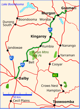 | |
| Bunya Highway (green and black) | |
| General information | |
| Type | Highway |
| Length | 173 km (107 mi) |
| Route number(s) | |
| Major junctions | |
| North end | |
| South end | |
| Location(s) | |
| Major settlements | Murgon, Wondai, Kingaroy, Kumbia, Bell |
| Highway system | |
The Bunya Highway is a state highway of Queensland, Australia. It is a relatively short road, running approximately 173 kilometres in a south-westerly direction from Goomeri to Dalby. The highway connects the Warrego and Burnett Highways.[1]
It is a state-controlled regional road (numbers 45A (Dalby to Kingaroy) and 45B (Kingaroy to Goomeri)).[2][3][4]
The Bunya Highway passes near the Bunya Mountains National Park, which is popular with tourists. The highway is named after the Bunya-bunya Araucaria bidwilli, which grows in the area and the seeds of which were (and still are) a favourite food of the Aborigines.
The road continues east of Goomeri as the Wide Bay Highway, connecting it to Gympie.[5]
In 2008, the intersection with Burnett Highway was reconstructed to favour Murgon-bound traffic.
List of towns along the Bunya Highway

Major intersections
| LGA | Location | km | mi | Destinations | Notes |
|---|---|---|---|---|---|
| Gympie | Goomeri | 0 | 0.0 | Northern end of Bunya Highway. Northern concurrency terminus with Burnett Highway | |
| 1.8 | 1.1 | Southern concurrency terminus with Burnett Highway | |||
| South Burnett | Kingaroy | 62.0 | 38.5 | ||
| Kumbia | 94.6 | 58.8 | Bunya Mountains Road – south – Bunya Mountains | ||
| Western Downs | Dalby | 170.3 | 105.8 | Dalby–Cooyar Road – east – Cooyar | |
| 172.2 | 107.0 | west – Chinchilla | Southern end of Bunya Highway. State Route 49 continues north–west for 450 metres, duplexed with the Warrego Highway, before turning south–west as the Moonie Highway. | ||
1.000 mi = 1.609 km; 1.000 km = 0.621 mi
| |||||
Intersecting state-controlled roads
The following state-controlled roads, from south to north, intersect with the Bunya Highway:
- Dalby–Cooyar Road
- Macalister–Bell Road
- Kingaroy–Jandowae Road
- Bunya Mountains Road
- Kingaroy–Burrandowan Road
- D'Aguilar Highway
- Memerambi–Gordonbrook Road
- Chinchilla–Wondai Road
- Wondai–Proston Road
- Murgon–Gayndah Road
- Kilcoy–Murgon Road
- Burnett Highway
Kingaroy–Burrandowan Road
Kingaroy–Burrandowan Road | |
|---|---|
| Location | Bunya Highway, Taabinga to Chinchilla–Wondai Road, Chahpingah |
| Length | 64.4 km (40.0 mi) |
Kingaroy–Burrandowan Road is a state-controlled district road (number 428), rated as a local road of regional significance (LRRS).[2][4] It runs from the Bunya Highway in Taabinga to Chinchilla–Wondai Road in Chahpingah, a distance of 64.4 kilometres (40.0 mi). It does not intersect with any state-controlled roads.[6]
Memerambi–Gordonbrook Road
Memerambi–Gordonbrook Road | |
|---|---|
| Location | Bunya Highway, Memerambi to Chinchilla–Wondai Road, Wilkesdale |
| Length | 25.1 km (15.6 mi) |
Memerambi–Gordonbrook Road is a state-controlled district road (number 4206), rated as a local road of regional significance (LRRS).[2][4] It runs from the Bunya Highway in Memerambi to Chinchilla–Wondai Road in Wilkesdale, a distance of 25.1 kilometres (15.6 mi). It does not intersect with any state-controlled roads.[7]
See also
References
- ^ Queensland Government - Department of Transport and Main Roads - Maps
- ^ a b c The State Road Network of Queensland (PDF) (Map). Queensland Government ©State of Queensland [CC BY 4.0]. 30 June 2022. Retrieved 4 August 2023.
- ^ "Darling Downs district map" (PDF). Department of Transport and Main Roads ©State of Queensland [CC BY 4.0]. 2019. Retrieved 21 February 2022.
- ^ a b c "Wide Bay / Burnett district map - Page 1" (PDF). Department of Transport and Main Roads ©State of Queensland [CC BY 4.0]. 5 August 2021. Retrieved 29 November 2021.
- ^ Hema, Maps (2007). Australia Road and 4WD Atlas (Map). Eight Mile Plains Queensland: Hema Maps. p. 9. ISBN 978-1-86500-456-3.
- ^ Google (8 November 2022). "Taabinga to Chahpingah" (Map). Google Maps. Google. Retrieved 8 November 2022.
- ^ Google (8 November 2022). "Memerambi to Wilkesdale" (Map). Google Maps. Google. Retrieved 8 November 2022.