Ben Lomond, West Virginia | |
|---|---|
| Coordinates: 38°42′28″N 82°10′40″W / 38.70778°N 82.17778°W | |
| Country | United States |
| State | West Virginia |
| County | Mason |
| District | Clendenin |
| Elevation | 561 ft (171 m) |
| Time zone | UTC-5 (Eastern (EST)) |
| • Summer (DST) | UTC-4 (EDT) |
| Area codes | 304 & 681 |
| GNIS feature ID | 1550259[1] |
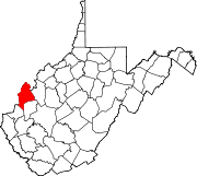
Ben Lomond is an unincorporated community in Mason County, West Virginia, United States. It is located on the eastern bank of the Ohio River at the junction of West Virginia Route 2 and County Route 56, (Mud Run Road), some 9.7 miles (15.6 km) south-southwest of Point Pleasant.[2]
Ben Lomond is in the watershed of Mud Run, one of the tributaries of Crab Creek. A CSX Transportation line — which was formerly part of the Baltimore & Ohio Railroad — runs through the community.[2][3] Ben Lomond once had a post office, which is now closed.[4] The community was named for Ben Lomond, a celebrated mountain in Scotland.[5][6]
YouTube Encyclopedic
-
1/3Views:1 1002 864 902577
-
The Buzz: Paranormal Investigation at Ben Lomond
-
Why There's a Straight Line Through Scotland
-
Good and Bad of Prince William Virginia
Transcription
History
Ben Lomond and adjacent settlements were in a region on the east bank of the Ohio River known as Mercer's Bottom since the 1790s. About a mile south of Ben Lomond is the settlement of Hogsett, near the mouth of Flatfoot Creek.[7][8] Hogsett received its post office in 1885 and Ben Lomond received its post office in 1886, and for a while the U.S. Post Office Department wavered between which village should keep one. Ben Lomond's post office closed permanently in 1919, while Hogsett's remained until 1967.[9]
References
- ^ "Ben Lomond". Geographic Names Information System. United States Geological Survey, United States Department of the Interior.
- ^ a b Mason County, West Virginia General Highway Map (PDF) (Map). West Virginia Department of Transportation. 2011. p. 2. Retrieved February 17, 2013.[permanent dead link]
- ^ Gannett, Henry (1904). A gazetteer of West Virginia. United States Government Printing Office. p. 164.
- ^ "Ben Lomond Post Office (historical)". Geographic Names Information System. United States Geological Survey, United States Department of the Interior.
- ^ Gannett, Henry (1973). The Origin of Certain Place Names in the United States. United States Government Printing Office. p. 334. ISBN 9780806305448.
- ^ Kenny, Hamill (1945). West Virginia Place Names: Their Origin and Meaning, Including the Nomenclature of the Streams and Mountains. Piedmont, WV: The Place Name Press. p. 106.
- ^ United States Geological Survey, Topographical Maps, Ohio-West Virginia, Gallipolis Quadrangle (ed. 1958, rev. 1975, 1983).
- ^ United States Geological Survey, Topographical Maps, West Virginia-Ohio, Apple Grove Quadrangle (eds. 1958, 2002).
- ^ United States Post Office Department, Record of Appointment of Postmasters, 1832–1971, NARA Microfilm Publication M841, West Virginia, Mason County.


