
Beit HaGadi
בֵּית הַגָּדִי بيت هجادي | |
|---|---|
 | |
 Beit HaGadi  Beit HaGadi | |
| Coordinates: 31°25′28″N 34°36′22″E / 31.42444°N 34.60611°E | |
| Country | |
| District | Southern |
| Council | Sdot Negev |
| Affiliation | Hapoel HaMizrachi |
| Founded | 1951 |
| Founded by | Hungarian and Romanian Jews |
| Population (2022)[1] | 867 |
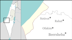
Beit HaGadi (Hebrew: בֵּית הַגָּדִי, lit. House of the Gad) is a religious moshav in southern Israel. Located near Netivot and the Gaza Strip, it falls under the jurisdiction of Sdot Negev Regional Council. In 2022 it had a population of 867.[1]
YouTube Encyclopedic
-
1/2Views:4 2597 161
-
Netivot - Yad Mordechai Western Negev Israel Highway 34 4K כביש 34 הנגב המערבי נתיבות יד מרדכי
-
Highway 25 Be'er Sheva - Netivot 4K כביש 25 באר שבע - נתיבות
Transcription
History
The village was established in 1951, and was initially named Beit HaGide'a. The founders were demobilised IDF soldiers who were members of Netiv BeMoledet organisation and Hapoel HaMizrachi. They were immigrants from Hungary and Romania, and had previously worked in Rishon LeZion.
Its name is taken from the Tribe of Gad, which lived in the area in biblical times, and the Bedouin village of Bit Hajadaa that appears on the Madaba Map.
References
- ^ a b "Regional Statistics". Israel Central Bureau of Statistics. Retrieved 21 March 2024.
External links
- Beit HaGadi Negev Information Centre
| Authority control databases: National |
|---|