
Ada, Alabama | |
|---|---|
 Ada  Ada | |
| Coordinates: 32°06′20″N 86°16′35″W / 32.10556°N 86.27639°W | |
| Country | United States |
| State | Alabama |
| County | Montgomery |
| Elevation | 322 ft (98 m) |
| Time zone | UTC-6 (Central (CST)) |
| • Summer (DST) | UTC-5 (CDT) |
| Area code | 334 |
| GNIS feature ID | 112911[1] |
Ada is an unincorporated community in Montgomery County, Alabama, United States. Ada is located at the intersection of U.S. Route 331 and Alabama State Route 94, 20 miles (32 km) south of Montgomery.
History
A post office operated under the name Ada from 1881 to 1922.[2] Ada was the name of the first postmaster's wife.[3]
Demographics
According to the census returns from 1850[4]–2010[5] for Alabama, it has never reported a population figure separately on the U.S. Census.[6]
References
- ^ "Ada". Geographic Names Information System. United States Geological Survey, United States Department of the Interior.
- ^ "Montgomery County". Jim Forte Postal History. Retrieved January 19, 2015.
- ^ Foscue, Virginia (1989). Place Names in Alabama. Tuscaloosa: The University of Alabama Press. p. 6. ISBN 0-8173-0410-X.
- ^ http://www2.census.gov/prod2/decennial/documents/1850c-11.pdf, 1850 Census (places)
- ^ http://www.census.gov/prod/cen2010/cph-1-2.pdf, 2010 AL Census
- ^ "US Census Bureau Publications - Census of Population and Housing".
Municipalities and communities of Montgomery County, Alabama, United States | ||
|---|---|---|
| Cities | 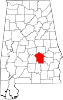 | |
| Towns | ||
| Unincorporated communities | ||
| Indian reservation | ||
| Footnotes | ‡This populated place also has portions in an adjacent county or counties | |
This Montgomery County, Alabama state location article is a stub. You can help Wikipedia by expanding it. |