

Şemdinli District is a district in the Hakkâri Province of Turkey.[1] The district had a population of 44,742 in 2023 with the town of Şemdinli as its seat.[2] Its area is 1,209 km2.[3]
The district was established in 1936.[4] Part of the district was separated to form Derecik District in 2018.[5] The current district governor (kaymakam) is Batuhan Taşgın.[6]
Settlements
There is one municipality in Şemdinli District:[1]
The district has twenty-two villages of which three are unpopulated:[1]
- Alan (Hālānā, Helane)
- Altınsu (Şepatan)
- Ayranlı (Bêdaw)
- Bağlar (Nehrî)
- Beyyurdu (Bêdevê)
- Boğazköy (Bêgoza, Mezrê)
- Bozyamaç (Bêmbo)
- Çalışkanlar (Kadana)
- Çatalca (Dîman)
- Çevre (Bay)
- Çubuklu (Bêntûr)
- Günyazı (Qelaşk)
- Kayalar (Katûne)
- Konur (Nixayila, Nuxaylan)
- Korgan (Gulenk)
- Meşelik (Herkî)
- Öveç (Sûrûnis)
- Tekeli (Gare)
- Tütünlü (Awliyan)
- Uğuraçan (Betkar)
- Yaylapınar (Salaran)
- Yufkalı (Nerdoşe)
The district has forty-two hamlets:[1]
- Aktütün (Bêzelê)
- Aşağıkayalar
- Aşağıtuğlu (Tûyê jêrî)
- Balıklı (Masîro)
- Binahare (Bîyaholê)
- Çamlıca (Bêşems)
- Çiçekli
- Deravi (Derawê)
- Dereyanı (Gûlkan)
- Elmalı (Sêvê)
- Erik (Ballê)
- Güleç (Rûyan)
- Güzekaya (Bêgirdê)
- Güzelkonak (Haruna)
- Harbanlı
- İncesu (Seraro)
- Karakuş
- Kayacık (of Beyyurdu)
- Kayacık (of Boğazköy)
- Kepenek (Kepenekyan)
- Koçbaşı (Geyman)
- Mağaraönü (Şkeftan)
- Meşeli (Bêmlate)
- Oğlaklı (Meleyan)
- Olgunlar (Bêbap)
- Öncü (Reşîdan)
- Rüzgarlı (Rubunus)
- Samanlı (Mezre)
- Sarıca (Zerîk)
- Seçkin (Zêvkan)
- Tanyolu (Gelêşim)
- Tuğlu (Tûyê)
- Üçgöze (Girik)
- Üstünağaç (Şawûtê)
- Üzümkıran (of Ayranlı, Dêhî)
- Üzümkıran (of Meşelik)
- Veliköy (Çemê Sofîvelî)
- Yaman (Zîzan)
- Yeniceli (Şeyhan)
- Yeşilbayır (Bêzeno)
- Yeşilköy (Feqyan)
- Zorgeçit (Kerketî)
Population
Population history from 1997 to 2023 (includes Derecik District until 2018):[7][2]
| Year | Pop. | ±% |
|---|---|---|
| 1997 | 38,816 | — |
| 2007 | 51,034 | +31.5% |
| 2012 | 67,173 | +31.6% |
| 2017 | 65,941 | −1.8% |
| 2022 | 42,471 | −35.6% |
| 2023 | 44,742 | +5.3% |
References
- ^ a b c d "Türkiye Mülki İdare Bölümleri Envanteri". T.C. İçişleri Bakanlığı (in Turkish). Retrieved 19 December 2022.
- ^ a b "Population Of SRE-1, SRE-2, Provinces and Districts". TÜİK. Retrieved 10 May 2024.
- ^ "İl ve İlçe Yüz ölçümleri". General Directorate of Mapping. Retrieved 1 March 2023.
- ^ "İl İdaresi ve Mülki Bölümler Şube Müdürlüğü İstatistikleri - İl ve İlçe Kuruluş Tarihleri" (PDF) (in Turkish). p. 38. Retrieved 27 December 2022.
- ^ "Hakkari Valisi Akbıyık, yeni ilçe olan Derecik'i ziyaret etti". T24 (in Turkish). 29 November 2018. Retrieved 1 October 2022.
- ^ "Kaymakamımız". www.semdinli.gov.tr. Retrieved 30 March 2023.
- ^ "1997 Population Count" (PDF) (in Turkish). Turkish Statistical Institute. 1999. Archived (PDF) from the original on 30 October 2022.
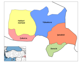
Şemdinli District in Hakkâri Province of Turkey | |||||||||||||||||||||||||||
|---|---|---|---|---|---|---|---|---|---|---|---|---|---|---|---|---|---|---|---|---|---|---|---|---|---|---|---|
| Districts |   | ||||||||||||||||||||||||||
|
Metropolitan municipalities are bolded. | |||||||||||||||||||||||||||