
Zwickau | |
|---|---|
 Flag  Coat of arms | |
 | |
| Country | Germany |
| State | Saxony |
| Capital | Zwickau |
| Government | |
| • District admin. | Carsten Michaelis (CDU) |
| Area | |
| • Total | 949 km2 (366 sq mi) |
| Population (31 December 2021)[1] | |
| • Total | 309,621 |
| • Density | 330/km2 (850/sq mi) |
| Time zone | UTC+01:00 (CET) |
| • Summer (DST) | UTC+02:00 (CEST) |
| Vehicle registration | Z, GC, HOT, WDA |
| Website | landkreis-zwickau |
Zwickau (German: Landkreis Zwickau) is a district (Kreis) in the Free State of Saxony, Germany.
YouTube Encyclopedic
-
1/1Views:6 429
-
GCSE Germany 19: Persecution of Minority Groups
Transcription
History
The district was established by merging the former districts Zwickauer Land, Chemnitzer Land and the urban district Zwickau as part of the district reform of August 2008.
Geography
The district is located in the northern foothills of the Ore Mountains, west of Chemnitz. The main rivers of the district are the Zwickauer Mulde and the Pleiße. It borders (from the west and clockwise) the state Thuringia, the district Mittelsachsen, the urban district Chemnitz, and the districts Erzgebirgskreis and Vogtlandkreis.
Towns and municipalities
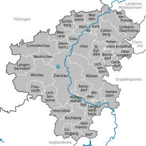
Towns
Municipalities
Notes
References
- Miller, Michael (2017). Gauleiter Volume 2. California: R James Bender Publishing. ISBN 978-1-932970-32-6.
External links
 Media related to Landkreis Zwickau at Wikimedia Commons
- Official website (in German)
50°45′N 12°30′E / 50.75°N 12.5°E
| Urban districts | |
|---|---|
| Rural districts | |
| Former urban districts | |
| Former rural districts | |
| International | |
|---|---|
| National | |