To install click the Add extension button. That's it.

The source code for the WIKI 2 extension is being checked by specialists of the Mozilla Foundation, Google, and Apple. You could also do it yourself at any point in time.

4,5
Kelly Slayton
Congratulations on this excellent venture… what a great idea!
Alexander Grigorievskiy
I use WIKI 2 every day and almost forgot how the original Wikipedia looks like.
What we do. Every page goes through several hundred of perfecting techniques; in live mode. Quite the same Wikipedia. Just better.
.
Leo
Newton
Brights
Milds

Sächsische Schweiz-Osterzgebirge

From Wikipedia, the free encyclopedia

Sächsische Schweiz-Osterzgebirge
Coat of arms of Sächsische Schweiz-Osterzgebirge
Map
CountryGermany
StateSaxony
CapitalPirna
Government
 • District admin.Michael Geisler (CDU)
Area
 • Total1,654 km2 (639 sq mi)
Population
 (31 December 2021)[1]
 • Total244,009
 • Density150/km2 (380/sq mi)
Time zoneUTC+01:00 (CET)
 • Summer (DST)UTC+02:00 (CEST)
Vehicle registrationPIR, DW, FTL, SEB
Websitewww.landratsamt-pirna.de

Saxon Switzerland-Eastern Ore Mountains (German: Sächsische Schweiz-Osterzgebirge) is a district (Kreis) in Saxony, Germany. It is named after the mountain ranges Saxon Switzerland and Eastern Ore Mountains.

YouTube Encyclopedic

  • 1/3
    Views:
    4 974
    11 580
    342
  • Schönheiten von Pirna in Sachsen Sächsische Schweiz Osterzgebirge
  • Wirtschaftstag 2010 in Freital Sächsische Schweiz Osterzgebirge - Mit Vorsprung in die Zukunft
  • Liebstadt Kreis Sächsische Schweiz Osterzgebirge 9.8.2013

Transcription

History

The district was established by merging the former districts of Sächsische Schweiz and Weißeritzkreis as part of the district reform of August 2008.

Geography

View from the viewpoint on the top of the Papststein. The three large mountains are Gohrisch (left), the Königstein Fortress (in exact centre) and the Lilienstein (right). The village on the right is Kurort Gohrisch.

The district is located between Dresden and the Czech Republic. In the southwestern part of the district the easternmost part of the Ore Mountains (″Erzgebirge") is found, the southeastern part of the district is named Saxon Switzerland, which is part of the Elbe Sandstone Mountains. The main river of the district is the Elbe. The district borders (from the west and clockwise) the districts of Mittelsachsen and Meißen, the urban district Dresden, the district of Bautzen, and the Czech Republic.

Towns and municipalities
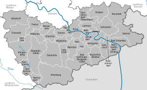
AltenbergBad Gottleuba-BerggießhübelBad SchandauBahretalBannewitzDippoldiswaldeDohmaDohnaDorfhainDürrröhrsdorf-DittersbachFreitalGlashütteGohrischHartmannsdorf-ReichenauHeidenauHermsdorfHohnsteinSebnitzKlingenbergKönigsteinKreischaLiebstadtLohmenMüglitztalNeustadt in SachsenPirnaRabenauRathenRathmannsdorfReinhardtsdorf-SchönaRosenthal-BielatalDippoldiswaldeSebnitzSebnitzStadt WehlenStruppenStolpenTharandtWilsdruffSaxonyCzech RepublicBautzen (district)DresdenMeißen (district)Mittelsachsen
Clickable map of towns and municipalities in the district
Towns Municipalities
  1. Altenberg
  2. Bad Gottleuba-Berggießhübel
  3. Bad Schandau
  4. Dippoldiswalde
  5. Dohna
  6. Freital
  7. Glashütte
  8. Heidenau
  9. Hohnstein
  10. Königstein
  1. Liebstadt
  2. Neustadt in Sachsen
  3. Pirna
  4. Rabenau
  5. Sebnitz
  6. Stadt Wehlen
  7. Stolpen
  8. Tharandt
  9. Wilsdruff
  1. Bahretal
  2. Bannewitz
  3. Dohma
  4. Dorfhain
  5. Dürrröhrsdorf-Dittersbach
  6. Gohrisch
  7. Hartmannsdorf-Reichenau
  8. Hermsdorf
  9. Klingenberg
  1. Kreischa
  2. Lohmen
  3. Müglitztal
  4. Rathen
  5. Rathmannsdorf
  6. Reinhardtsdorf-Schöna
  7. Rosenthal-Bielatal
  8. Struppen

Transport

The district owns the Regionalverkehr Sächsische Schweiz-Osterzgebirge, a transport company that provides bus, ferry and tram services to the district.

See also

References

  1. ^ "Bevölkerung des Freistaates Sachsen nach Gemeinden am 31. Dezember 2021" (XLS) (in German). Statistisches Landesamt des Freistaates Sachsen. 2022.

External links

Media related to Landkreis Sächsische Schweiz-Osterzgebirge at Wikimedia Commons

50°54′N 13°50′E / 50.900°N 13.833°E / 50.900; 13.833

This page was last edited on 9 April 2024, at 20:55
Basis of this page is in Wikipedia. Text is available under the CC BY-SA 3.0 Unported License. Non-text media are available under their specified licenses. Wikipedia® is a registered trademark of the Wikimedia Foundation, Inc. WIKI 2 is an independent company and has no affiliation with Wikimedia Foundation.