
Trammels, Missouri City, Texas | |
|---|---|
 Trammels Location within the state of Texas  Trammels Trammels (the United States) | |
| Coordinates: 29°32′05″N 95°32′15″W / 29.53472°N 95.53750°W | |
| Country | United States |
| State | Texas |
| County | Fort Bend |
| Elevation | 66 ft (20 m) |
| Time zone | UTC-6 (Central (CST)) |
| • Summer (DST) | UTC-5 (CDT) |
| ZIP code | 77459 |
| Area code(s) | 281, 713, 832 |
| GNIS feature ID | 1379172[1] |
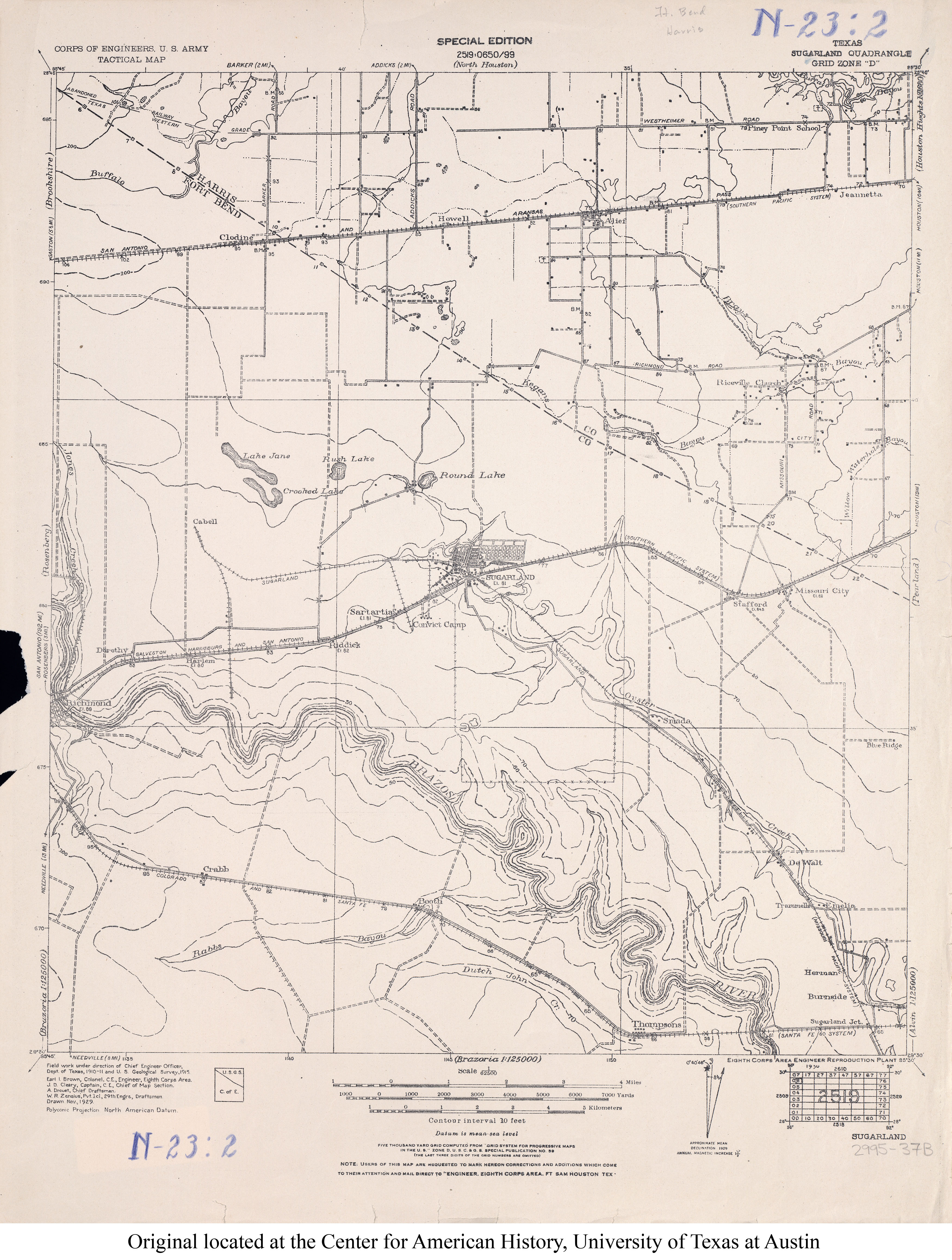
Trammels (sometimes spelled Trammells) was an unincorporated area near State Highway 6 in eastern Fort Bend County, Texas, United States.[2]
YouTube Encyclopedic
-
1/2Views:1 1714 974
-
The Huntington Active Senior Living Apartments - Missouri City Apartments For Rent
-
Life on the Mississippi By Mark Twain [Part 1/5] VideoBook
Transcription
Location
Trammels was located on the southwestern side of Oyster Creek, twenty miles east of Richmond, at the junction of a graded and drained road and what later was designated as McKeever Road (which paralleled the railroad tracks in this vicinity).[3] It was about one mile west of the present-day junction of Texas State Highway 6 and Trammel-Fresno (sic) Road. This is near what later became the south terminus of the Fort Bend Tollway, approximately halfway between U.S. Highway 59 and State Highway 288. The remnants of Trammels are within the city limits of Missouri City, a Houston suburb, after having been annexed in October 1981.[4]
History
Little is known regarding the early history of the town, though there are some records of the development of the neighboring town of DeWalt, of which community Trammels became a part. In 1936, Trammels had a row of dwellings, one business, and five farm units. Although it appeared on county maps, population statistics were never recorded.
Transportation
Trammels was a station stop on the Gulf Coast Lines' Sugar Land Railway, with one mixed train scheduled daily except Sunday between Sugar Land and Anchor in 1925.
See also
- Official Guide of the Railways, February 1926, page 743
References
- ^ U.S. Geological Survey Geographic Names Information System: Trammels, Missouri City, Texas
- ^ USGS (1915). Sugarland (sic) Quadrangle (JPEG) (Map). Perry-Castañeda Library Map Collection. Retrieved April 24, 2021.
- ^ Trammels, Texas from the Handbook of Texas Online
- ^ Annexation Map (JPEG) (Map). Missouri City. 2017. Retrieved May 2, 2021.
External links
- Trammels, Texas from the Handbook of Texas Online
Municipalities and communities of Fort Bend County, Texas, United States | ||
|---|---|---|
| Cities |  | |
| Town | ||
| Villages | ||
| CDPs | ||
| Other communities | ||
| Former communities | ||
| Ghost towns |
| |
| Footnotes | ‡This populated place also has portions in an adjacent county or counties ±Former community annexed by Missouri City ^Former community annexed by Sugar Land #Still active as a community, but is no longer listed as a census-designated place | |