
 | |
 | |
| Geography | |
|---|---|
| Location | Australia |
| Coordinates | 9°16′01″S 142°13′01″E / 9.267°S 142.217°E |
| Administration | |
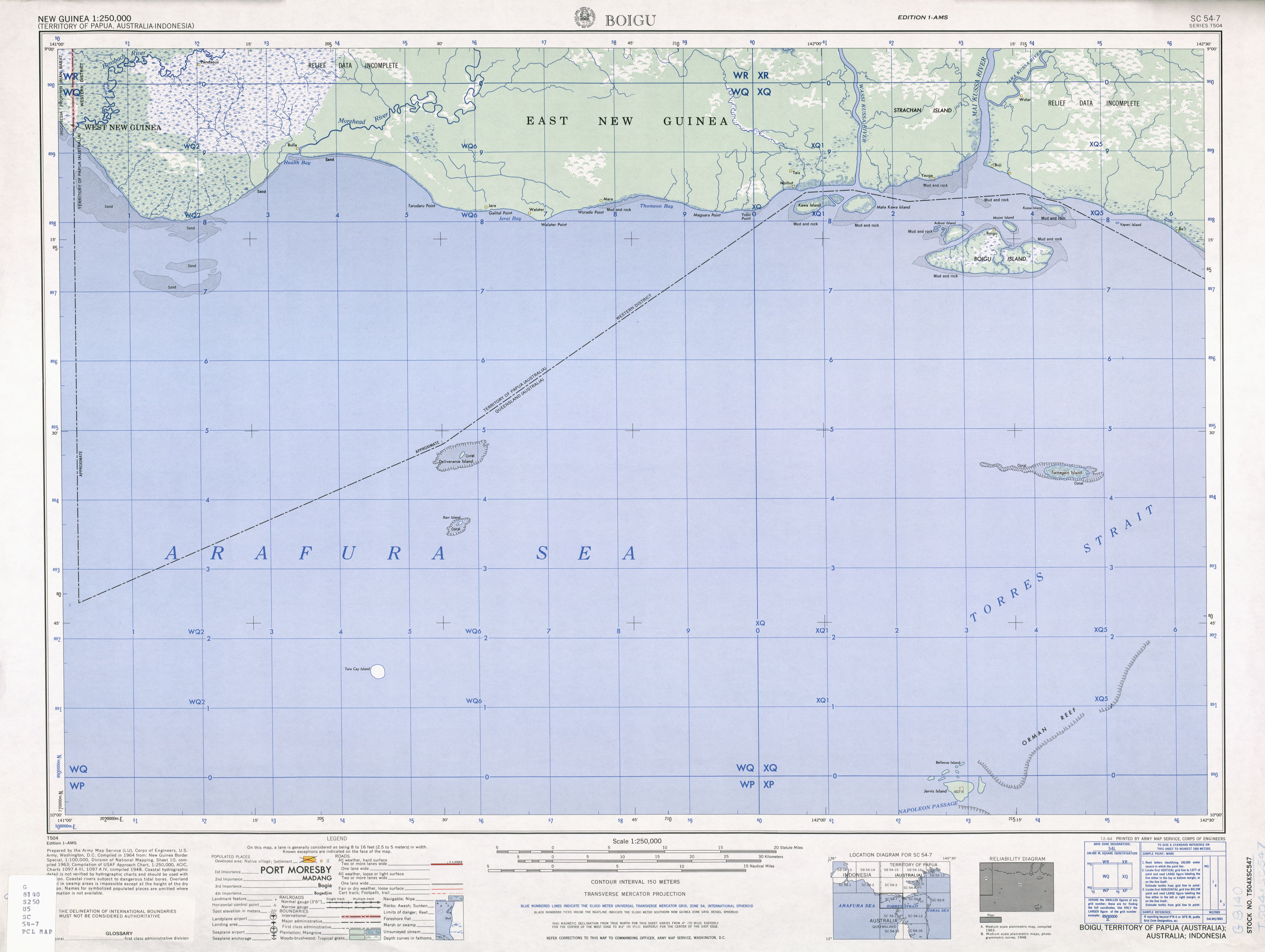
Talbot Islands are a group of Torres Strait Islands in Queensland, Australia.[1] They lie between the Australian mainland and the island of New Guinea and a few kilometres west of Saibai Island, Torres Strait, only 4 km from the Papua New Guinea mainland at the mouth of the Mai Kussa River.
The Talbot Islands contain five named and about six smaller islands:
- Boigu Island
- Moimi Island
- Aubussi Island
- Moegina Kawa
- Aymermud
Only Boigu Island is inhabited. The town of Boigu is the northernmost settlement of Australia. Moimi Island, the northernmost island, is only four kilometres away from Kussa Island, which has been recognised part of New Guinea in the 1978 Torres Strait Treaty,[2] but delineated as part of Australia on older maps.[3] Kussa Island and tiny nearby Athian Maza and Yaperi (Vapere) islands, also at the mouth of the Mai Kussa River, are geographically part of the island group, as are the Kawai Islands (Kawa Island, Karobailo Kawa Island, Adabadana Kawa Island and Mata Kawa Island) nine kilometres further west/west-northwest close to the mouth of Wassi Kussa River, which have also been part of Papua New Guinea since the treaty of 1978.[4]
Strachan Island is a large river island between the Wassi Kussa River and Mai Kussa River and borders the Torres Strait with its southern shore, but is not part of the Talbot or Torres Strait Islands. It is inhabited.
The Talbot Islands, along with Saibai and Dauan, are known as the Top Western islands of the Torres Strait Islands
YouTube Encyclopedic
-
1/3Views:2 8701 0138 723
-
Island Property For Sale - Talbot Islands, Cognashene, Georgian Bay
-
Little Talbot Island State Park - Sept 2019 - Secluded Florida Beaches in Jacksonville
-
Charming Cottage on Private Island in Sans Souci, Georgian Bay, Ontario
Transcription
References
- ^ "Talbot Islands – island group (entry 33165)". Queensland Place Names. Queensland Government. Retrieved 1 August 2021.
- ^ "Treaty between Australia and the Independent State of Papua New Guinea concerning Sovereignty and Maritime Boundaries in the area between the two Countries, including the area known as Torres Strait, and Related Matters [1985] ATS 4". www.austlii.edu.au. Retrieved 3 November 2019.
- ^ "Boigu" (Map). US Army. 1948. Retrieved 30 March 2022.
- ^ "SOUTH COAST OF PAPUA NEW GUINEA—BENSBACH RIVER TO SOUTH CAPE" (PDF). PUB. 164. SAILING DIRECTIONS (ENROUTE). National Imagery and Mapping Agency, United States Government. 2003.
List of Torres Strait topics | |||||||||||||||||||
|---|---|---|---|---|---|---|---|---|---|---|---|---|---|---|---|---|---|---|---|
| Torres Strait Islands, islets, and cays |
| ||||||||||||||||||
| People, culture, communities and languages |
| ||||||||||||||||||
| Governance and legal matters |
| ||||||||||||||||||
| Buildings and structures | |||||||||||||||||||
| Other | |||||||||||||||||||
This Queensland location article is a stub. You can help Wikipedia by expanding it. |